 Written by: Bob Metcalfe
The posts on this weather blog remind me of all the conversations we had in the weather lab in college. We'd all talk about the 364 hour GFS runs like they were gospel and drool, even though deep down we knew it wasn't going to happen. I love it!
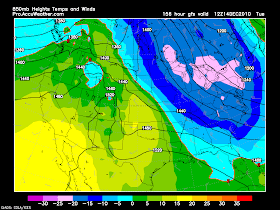
Well once in a while, things actually come to fruition, and in this case the long range models have now consistently indicated a coming storm this weekend (as if that was a big surprise!) Track location will probably give us a sloppy mix for at least several hours Sunday, but all of us will get the cold and lake effect snow behind it. Above I have posted the 850 mb temps for early next Tuesday morning and yeah, they're cold. The pink shading over western NY indicates 850 mb temperatures dropping to the -4 to -13 degree Fahrenheit range... which can very well yield single digit lows in our area provided the right conditions. Not to mention that at the surface at this time, it'll be windy with some decent lake effect snow likely.
So button down the hatches. This recent snow got a lot of people "ready" for winter, so this next little guy should be "nothing" for us. Right? Okay maybe not, but I'm a lot more prepared... I finally got a snowblower. Bring on the feet and feet of snow!
NWS is forecasting 10-14 inches of snow tonight in ontario and northern Wayne county
ReplyDeleteWhat's up with this foot plus of new snow for Wayne county tonight? (NWS prediction.)
ReplyDeletenews 8: 2-4 inches
ReplyDeletenws: 12-16 inches
something does not add up
NWS said 3-5 for Geneva last night, and 2-4 today. so far, we have a slight dusting.
ReplyDeleteWhat sucks the most is that I believe that I am way under my snow prediction for December. We are up over a foot of the stuff right now and still counting.
ReplyDeleteHow much is actually on the ground in Geneva? Just a dusting?
ReplyDeleteI've tweaked... 6-12 is very possible in that focus point in Wayne CO.
ReplyDeleteSnowing heavily in Sodus... roads are rough in N. Wayne Cty.
ReplyDeleteIt's amazing how pencil-thin the band is through Wayne county right now. I'd say its at most 5-8 miles wide.
ReplyDeleteWhat do the latest models say about the storm this Sunday?
ReplyDeleteWe have got about an inch and a half if not 2 inches in Ontario so far this morning
ReplyDeleteGFS 12z takes about the same track GFS 00z took! That probably means: first snow, than rain/mix,than snow! Its going to be really interesting.
ReplyDeleteWe could have a significant icing by looking at the models during the middle of the day on Sunday with it changing over to snow later in the day... I do not think we will see all rain up in Rochester it just will be too cold at the surface I think it will be either sleet or freezing rain
ReplyDeleteThe trends are definitely for a colder track. Aside from the GFS, the Euro (ECMWF) has shifted to a colder track in its 0z run last night. It is more in line with the GFS now. Given that we are under 100 hrs out, I think this colder track looks much more likely than it did a couple days ago.
ReplyDeleteI don't see freezing rain with temps aloft being too chilly based on the latest GFS. If that were to verify, expect mostly snow with perhaps a period of snow and sleet mixed. But no rain.
Scott, what is your take on the latest trends in the models?
so we at least agree no rain... we will have to see about freezing rain... even sleet can cause major icing problems just not as bad as freezing rain can
ReplyDeleteThe latest GFS (12z) does not even have the 0C 850 mb level line cross us at all during the storm... also with the winds that it shows we will be borderline if not a blizzard... Accuweather has been talking about a blizzard for interior portions of NY
ReplyDeleteIf it does change over to sleet or freezing rain, it should be brief before the colder air rockets in. I wouldn't be surprised to see all out blizzard conditions Sunday evening into early Monday.
ReplyDeleteHere is my blog update on the storm sunday and the weather tonight... http://rochesternyweather.blogspot.com/
ReplyDeleteI wouldn't jump on the GFS just yet. The latest run of the euro has a very different solution, with a low cutting up right over us. It's solution would mean warmer temps and a much higher chance of mixed precip or even rain for a period of time. That model cannot be ruled out because it is superior in terms of its grasp of the physics of the atmosphere. Until we start to see a consensus between the GFS and Euro for at least a couple runs, I would consider this forecast to be low confidence.
ReplyDeleteDamn...this is interesting stuff!
ReplyDeleteDoug
I think that we may finally have some confidence on Wednesday next week about the storm on Sun - Tues
ReplyDeleteDK is right. EURO is MUCH more trustworthy as well as the rarely mentioned and looked at Canadian ensembles. You need to look at a collection of data, climo to make a responsible forecast. Sunday will start snow, wintry mix then over to bitter cold and lake snows Monday-Wednesday.
ReplyDeleteTemps Monday will hover around 10 and lows near zero or low single digits Tuesday. This setup will always produce locally heavy lake snows and whiteouts.
Scott
Scott,
ReplyDeleteBased on this setup any reason to believe that we are looking at a heavier lake snow event in Monroe County Mon-Wed next week compared to what we experienced this week?
Scott
ReplyDeleteAre you saying that we will not get a significant area wide snowfall from the storm itself?
I'm saying that in the first few hours of the storm we will see area wide snowfall. Perhaps a few inches before a wintry mix. I expect that Monroe county could see similar snow amounts given the depth of cold air coming as well as the high snow to liquid ratios we'll see (30:1) means it will pile up.
ReplyDeleteBlizzard conditions likely if this storms deepens like I expect.
Scott
What about tonight, will these lake effect bands affect northern monroe at all? Brockport, greece, iroq..
ReplyDeleteis the lake effect snow over in Brighton? and is there a good chance of getting a blizzard on Sunday though monday?
ReplyDelete