
WAYNE COUNTY CONTINUES TO GET THE MOST
Written By: Scott Hetsko
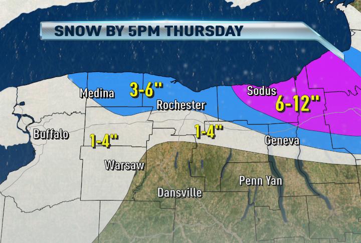
Here's the new snowmap for the area through noon tomorrow. You can clearly see the Central and Eastern Wayne County runs the highest risk of up to a new foot of snowfall in some towns. Monroe and Orleans County will see several inches in total as snow showers spray that area along with two upper air disturbance which will briefly enhance snow. If you are near or South of the thruway, don't expect a whole lot from the remainder of the lake effect. Weak ridging of high pressure will squash the snow for many except NE Wayne, Oswego Thursday night and Friday.
Glad it is over you guys must be also way to hard to predict LES. Unfortunately may be another round next Mon-Tues. Wish that band would have developed to dump 6-12 last night or tonight on the metro.
ReplyDeleteNot really over yet though, more accumulations of 3-6" in the city possible.
ReplyDeleteScott
Look like radar is getting more active now out over the lake and monroe county Scott.
ReplyDeleteIt's funny, just like clock work...once the sun begins to get low in the sky, the snow starts to fly.
ReplyDeleteOnce the sun goes down, less turbulence in the boundary layer and VIOLA sn
ReplyDeleteScott
I like Scott's term "snow guns"...and how they come out to play at night. LES is better than no S at all, although I am in the disappointed camp with regards to that band last night. So sad. Let's hope things kick on a little bit more tonight for good measure.
ReplyDeleteI live in Newark and will be waiting for the snow to start. Lets get it going
ReplyDeleteI need reports from Wayne County tonight. Radar is awful in your area. I'm talking to you Sodus, Newark, Palmyra, Macedon ETC
ReplyDeleteScott Hetsko
All do respect about being over but the 6-10 predictions last night were a little more exciting than the 3-6.
ReplyDeleteOntario, NY: Heavy snow... white out conditions right now
ReplyDeleteLyons: heavy lake snows, and whiteout conditions. snow at as of 4 pm measured at 2 1/2 feet since it started on monday.
ReplyDeleteThanks, Lyons! I've been wondering about you. 6-12" more coming your way...
ReplyDeleteScott
1/2 mile SE of Bear Creek Harbor, Ontario. Not a flake to be seen at 5:36 PM! JB
ReplyDeleteLet me add to the Lyons comment...that 2 1/2 feet since Monday is in addition to the 3+ feet here last week.
ReplyDeleteJust drove from Lyons to Sodus. Heavy snow north of Lyons, south of Sodus. Up at the Point, it is mostly cloudy. Lyons easily is the winner in the Wayne Co. snow derby, with 2.5 feet. Clyde, 7 miles to the east has about 1.5-2 feet. In Sodus Point, this pattern continues to disappoint, with only another 2" today and a total of about 8-9".
ReplyDeletein Brighton didn't get that much snow from this storm got more last time then now... weird
ReplyDeleteHang in there Sodus Point, you've gotta get a good period of snow at some point
ReplyDeleteScott,
ReplyDeleteIs that odd looking "rope" of lake effect crossing in from Ontario Canada the band that may setup across Rochester overnight?
LES just does not hit the city and monroe county with big snows unless you are right next to the lake. The opposite can be said for Syracuse. The city always get a great deal of LES snow and thus we will always be the loser in the thruway snow derby.
ReplyDeleteRochester has won the thruway derby multiple times before.
ReplyDeleteHow many times in the last 15 years?
ReplyDeleteHey Scott,
ReplyDeleteWhat did happen with that snow not hitting the city last night and tonight as you originally thought? Just interested what happen weather lingo wise. Thanks
Twice in the last 15 years. And Buffalo has also only won twice in the last 15 years. Yes, Syracuse has the majority of wins, but it's all relative. Rochester's annual snowfall is second only to Syracuse. Believe it or not, we average more snow annually than even Buffalo. And we have totaled more snow each year than Buffalo the vast majority of the last 30 years. We get our fair share - and those who complain only prove just how spoiled we are when we're complaining after picking up 42" of snow in the last two weeks!
ReplyDeleteSometimes even when your right on the lake, you don't get the lake snows either, anonymous! Hilton got a whopping 5 or 6 inches this time and about the same last time. I don't get it, but it's true! I'm waiting for a big snow for our area next time...
ReplyDeleteI'm seeing some definite signs of veering at the upper end of the Georgian Bay band. If that continues to ripple down the band, we may have it settle right across Rochester later this evening.
ReplyDeleteAs for the snow derby, something to consider: Official measurements are taken at a city's airport. Rochester's airport is located to the southwest of the city, several miles out of prime Lake Ontario snow, typically. Syracuse's airport is north of their city, where more snow piles up every mile further that you go. Syracuse's airport is only a few miles south of the Oswego County line, a big snowfall location. The southern end of the city backs up against the hills of the Alleghany Plateau, and there is humongous drop-off in snowfall totals from the north to the south end of the city.
ReplyDeleteScott,
ReplyDeleteWhy is the snow coming off lake Ontario into Monroe county so cellular in nature on the radar? It doesn't have that organized banding look to it. Is it undergoing shear or something?
That band is really building up and about set to crash onshore in Monroe county.
ReplyDeleteHere we go....Heavy snow beginning to settle into the northern suburbs of Rochester. Any reports from Greece, Irondequoit or Webster?
ReplyDeleteLight snow, north greece/charlotte
ReplyDeleteVery HEAVY snow on Manitou Rd near the Parkway
ReplyDeleteAlot of questions tonight where is Scott?
ReplyDeleteI'm here everyone! Just busy, thanks. I'll be adding some thoughts here shortly. Enjoying the discussion.
ReplyDeleteScott
It is strange if you look at 13wham.com weather site and the radar it looks like everyone is getting snow particularly heavy west of us and it looks like it is heading east.I do not think that radar is accurate?
ReplyDeleteBand becoming much better organized now. Cellular before because of wind changing direction with height (vertical shear) that is ending now.
ReplyDeleteScott
There sure is a strong band southwest of the city and it seems to be lifting north and strengthening... it may combine with the band that is over Rochester right now... maybe another good lake band tonight :)
ReplyDeleteHey who knows maybe Scott will have to adjust his forecast and bring that bigger overnight snow back to the metro!
ReplyDeleteScott,
ReplyDeleteThis is some talk on other blogs that th eeast coast storm will move more west and go up the coast. The talk is the storm will get up north and retrograde like the one last week? If so does that mean big LES again?
Dry air killed us last night! Just not enough moisture in the low levels. Sensible and latent heat flux can only do so much without humidity. I've seen many perfect multiband setups get squashed by dry air!
ReplyDeleteScott
Man that ultimate doppler on the 13wham.com weather site has a huge swath of green out west and looking like it is going east and north. The greemn is dark I assume that means heavier snow?
ReplyDeleteModerate snow in Gananda.
ReplyDeleteSCott, why have there been no synoptic storms in the past few weeks. We have the cold air, but there are no storms.
ReplyDeleteLooks like perfect multi bands set up now?
ReplyDeleteIt will probaly stay like this or similar most of the overnight hours. There have been storms just not favorable for a widespread snowfall.
ReplyDeleteScott
The NWS states that there will be a limited lake response with next weeks storm because ti will pull in warmer air?????????????????What are they talking about.
ReplyDeleteScott do you think that band between Rochester and Buffalo will come into the metro area tonight. It seems to be moving slowly eastward
ReplyDeleteI live in Perinton and it seems colder out tonight and the winds seem stronger tonight as compared to last night.
ReplyDeleteThe band is forecast to combine with the Georgian Bay band. Together they will be intense overnight in Wayne County. I expect Rochester to see a period of moderate snow before morning as well. A few inches just within that band.
ReplyDeleteScott
Here in Ontario we have gotten periods of heavy snow with an inch in the last hour and a half or so
ReplyDeleteCouple things working again next week. First the storm will be well off the East Coast. Second is the warm air wrapping around the system. You still need cold air even for Lake Enhancement.
ReplyDeleteScott
Thanks Scott for clarifying bc it looks worse on the radar for the city than it will be.
ReplyDeleteWhy would it wrap warm air if it moves to our East?
ReplyDeleteThe storm will stall over the ocean where warmer air is located and it'll throw it back over us. It won't mean a huge rise in temperatures but not good for lake snow production.
ReplyDeleteScott
moderate snow coming down in Scottsville from this band
ReplyDeleteIt looks the band over Eastern Monroe into Wayne County is also getting stronger.
ReplyDeleteIt is and will overnight. Portions of Wayne County will get heavy snow overnight.
ReplyDeleteScott Hetsko
Moderate snowfall in Newark right now...looking forward to some huge totals for the night.
ReplyDeleteWhere's my bloggers?
ReplyDeleteWe're still here...at least I am. Radar is lookin nice and healthy. Still seeing 3-6" for the metro or are we looking at maybe a bit more?
ReplyDeleteYeah I don't expect the steady/heavy band to stay over Rochester for long. Wayne cty does best. Good night.
ReplyDeleteTHE SNOW DID NOT MATERIALIZE LAST NIGHT. ONLY AN INCH IN GANANDA IN WAYNE COUNTY. WHAT HAPPENDED???????///??
ReplyDeleteSorry, I was outside throwing my snow shovel and kicking my snow plow. Maybe we'll get lake snow from the next round. I was hoping to atleast have 3" with all of this, wasn't expecting 2" over 4 days. oh well, the joys of living 5mi south of the TW
ReplyDeleteTo those asking, "What Happened?" Winds shifted more west and southwest so there wasn't much time for any bands to get set up over our area.
ReplyDeleteSuch is the nature of lake effect. It is very sensitive to small subtle changes. -Brian