THAT UNSETTLED FEELING

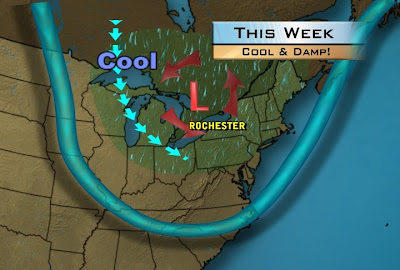
There are a couple of unsettling things going on this week. One is the weather. An upper level storm system will sit over the Great Lakes causing skies to be cloudy, bringing with it, cooler temperatures and also spark scattered showers and thunderstorms. This system is cut off from the main flow of the jet stream which is also farther south than it should be this time of year. This will keep this storm meander over the lakes until Friday when it finally gets a push and lifts out of the region by the end of the week. With its exit we should see a drier and warmer Fourth of July weekend.
The other unsettling thing is the lack of summer weather. As we close out the month of June and using the last 29 days, Rochester's temperature has been 2.3 degree below the average for the month and whatever rain deficit we were experiencing was erased this month. We are 2.22" over the average value of 3.26". That places us almost 2 inches over for the year with precipitation. If this continues it looks like 2009 could be a cool and wet summer.
No comments:
Post a Comment