Mild to Start Week; Warm End!
Written by John DiPasquale:
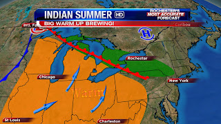
After a great day today with sun & unseasonably mild temperatures to begin the week, later this week a true Indian Summer appears to be in store! Tuesday & Wednesday will serve as transition days, with some rain likely Tuesday ahead of a warm front, & a few lingering showers/sprinkles here Wednesday. Highs Tuesday will struggle to get out of the 50s, while we should be up between 60 & 65 here Wednesday.
The warm front in the above pic should make it's way through late Wednesday night/Thursday morning, as a storm system hooks to the north & west. This will unleash almost summery warmth with highs reaching well into the 70s both Thursday & Friday with warming southerly breeze!! To go along with the incredible warmth will be a good amount of sunshine! Have those golf clubs& shorts ready, they'll be needed once again to round out the week!
Come the weekend, though, colder changes will ooze in, especially come Sunday when temperatures will likely tumble back into the 40s with some rain showers possible. Stay tuned to News 8 for updates throughout the week.

No one even mentioning the possibility of a storm in a week? Surprised. It is early but if all the ingrediants come together it could be a doozy. Just saying worth a watch.
ReplyDeleteThe Weather channel came out with their 3 month forecast through January and it does not look good for snow lovers in Western, Ny. They are saying much above normal temps right through January. Could this be a 2011-2012 winter repeat?????
ReplyDeleteForget the the next 3 months I think our news 8 team has to focus on the next week. There are many ingrediants out there for a historic storm on the coast early next week. It is a matter of if the ingrediants come together. There is 50/50 chance of big precipitation totals early next week. What does Scott and his team think.
ReplyDelete