CRUEL COLD CONFOUNDS ROCHESTER

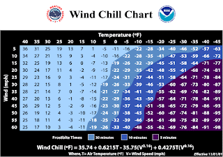
Chart Courtesy: National weather service
Written by: Scott Hetsko
We've been advertising a brutal shot of cold air since the start of the new year...now it's here! Temperatures will likely remain below 10 degrees right through Saturday morning. This airmass was born in Siberia and has slowly migrated East and South over time.
Another quick moving storm will pass just South of N.Y. on Thursday but we'll be close enough to get at least a few inches of snow and blowing snow. Wind chills will range from -10 to -20 during the day Thursday! Friday morning will likely be the peak of the cold snap with morning lows around -5 in Rochester but easily -10 to -15 in the valleys South and East. As a matter of fact, Watertown and others up the Saint Lawrence river valley could reach -30 degrees!!!
No comments:
Post a Comment