
DREAMING OF A WHITE CHRISTMAS?
The way this month has been going, it seems like it'd be impossible to NOT have a white Christmas! I've been watching the day approach in the longer range models and it looks like a late week storm will hit the east coast pretty hard, leaving us with just the minor amounts of the white stuff. I call this the ideal snow because it won't make local travel problematic but still give everyone the warm-and-fuzzies for the holiday.
Update: current December snowfall stands now at 45.6"... still in 3rd place, but just a smidge more and we're there. It's pretty much inevitable. A few lake snow showers on Monday could do the trick if they make it far enough inland from the lakes and happen to land at the airport measuring station. If not, then by Christmas it'll get done!
How much accumulation for monday?
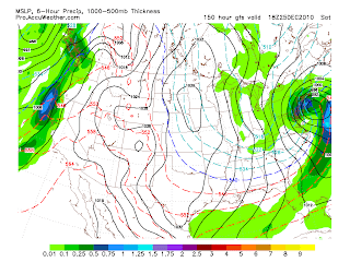
ReplyDeleteHave you seen the latest GFS. It has the storm much further West giving Western, NY a nice snowstorm. The GFS has it bombing over South Western, NY.
ReplyDeleteThe trend looks to be further West with this storm.
ReplyDeleteI meant South Eastern, Ny. We will see what the models do. The Euro has it much further South and a lot weaker.
ReplyDeleteScott said it was going south he is the best!
ReplyDeleteHow can people say GFS has us getting storm yet the news 8 team said minor accumulations? I trust the experts when they read the models.
ReplyDeleteGFS changes all the time so this is possibly, but the chance that you still see it in the next run again is pretty low!
ReplyDeleteThe chances that 18z takes the right track for the storm are pretty low, too, but if not... :D wow
Look at the latest GFS that just came out. It moves the storm much further West. Scott and the rest of channel are most likely correct. I am just looking at the latest GFS. It is just something to look at. I know we should not go on model to model runs, but some of the talk out of the NWS in different location is a further west track. We can only hope!!!!!
ReplyDeleteThe Oz will be one look at to see if it similar to the 18z and now a trend may develop if not then the 18z was just an aboration.
ReplyDeleteOK. No more looking at model to model runs. The new 0z run of the GFS takes a much weaker system way to the South and out to sea like the Euro. Not even the big cities see a lot.
ReplyDeleteSeriously. Is it just me, or has the GFS gotten absolutely terrible with its flip-flopping this year? It's all over the place from run to run up until about hour 72 for every storm. It seems to have a terrible read of the atmosphere. No wonder the EURO is considered superior.
ReplyDeleteThis is such a terrible waste of cold air. We have had cold air for the past 3 weeks. How many synoptic storms? A big 0. This has been the patter for several years. Cold air= no storms. Just nickle and dime lake effect. All those rain storms we had in the fall. Where are they now.
ReplyDeleteRemember Scott told you going south he is the best! You can not look at one run and think that is the answer.
ReplyDeleteGo pound synoptic snow in your butt. Sick of hearing it. I am going to make a LES angel.
ReplyDeleteThat one run was wishful thinking. To the commentor about sick of hearing about synoptic snow: You have to remember that many areas away from the lake did not receive snowful and still show grass. I am thinking of them. The snow lovers South of Rochester are dreaming for snow and the only way they get it is through synoptic systems that we never receive.
ReplyDeleteI agree, News 8 is the most accurate. No doubt. The other channels have been very inaccurate time and time again.
ReplyDeleteWell, the GFS no longer shows a major storm for us. But ironically enough, now the Euro shows a major storm hitting us the day after christmas with a low positioned right where the GFS's dream run had its big storm. Something's cooking.
ReplyDeleteIt is still 5 to 6 days away things could change. If not mistaken the accuracy will not come until model consensus two days before?
ReplyDeleteOk all you knowledgable model readers what is the 10:30 GFS saying?
ReplyDeleteI am no expert but it looks like the latest GFS run aligns itself with the Euro. These if they play out accurately I believe gives us a snow storm on Sunday?
ReplyDelete12z GFS keeps the storm to our south and east. No direct impact. We'll miss the storm, as we usually do.
ReplyDeleteYep south just as the most accurate forecaster in Rochester has said from the beginning. Forget the models just listen to Scott he has been wrong in once in two years. He corrected that last week.
ReplyDeleteI am not sure what models your are talking about. The new GFS still shows the storm well to our South and very weak at that.
ReplyDeleteProbably a few flurries and thats about it. Even TWC says fluries and nothing much :) I dont have to go anywhere so it doesnt matter to me. It could snow waist high to a 10 foot circus clown but the days of those type storms have long past.
ReplyDeleteSorry to disappoint but we won't get a DIRECT hit from that storm diving into the Mid Atlantic on Christmas Day. I do expect increased snow off of Lake Ontario on Sunday as colder air gets drawn South as that storm deepens.
ReplyDeleteSeveral inches possible Sunday into Monday for lake favored areas but yet again the region as a whole will miss out of a significant snowfall.
Scott
Scott, the lake effect for sunday, monday. will that be east of lake ontario or the south, 104 region as the last few were?
ReplyDeleteWhy are the models having such a hard time with the storm for Sunday, Monday. I looked at all the conversation out of the NWS offices in New Yro, Boston, Albany, Philadelphia, Erie, Syracuse and no-one has any idea what this storm will do. Scott, Brian, Bob. What are you guys looking at that make you sure this storm will not affect us at all? Thanks
ReplyDeleteThis storm is either huging the coast or going OTS. It will not impact us directly a little with LES. All the model runs show this not sure why there is confusion on your part. Maybe the confusion is with will it hit NE area.
ReplyDeleteIf it hugs the coast we will get snow...
ReplyDeleteALl the talk out of NWS offices is confusion. No-one knows where this storm is going to go, how strong, etc. If it hugs the coast we will get snow, especially with a NE wind we could get some lake enhancement. Of course, as always, the heavy snow will miss us unless it comes further inland.
ReplyDeleteSome of our biggest snows come on NE winds with lake enhancement. Lets face it, its difficult to get storms that target western NY in the bulls-eye. Just the way it is with our location. But a coastal huger with NE winds we always get 15"-20"+ not to mention the residual lake enhancement and lake effect...
ReplyDeleteThat is not happening David so I just wish people would stop making up stuff that is not coming. As the guru Scott said this storm is well south of us! Light stuff sorry strom starved people.
ReplyDeletewhere do you guys find the GFS models...just wondering because I would love to see them and learn how to read them.
ReplyDeleteIm not talking about this storm Mr. Anonymous. Im talking about later next week....
ReplyDeleteDavid so now you are predicting a coastal hugger that will give 15-20 later next week. Way to predict 10 days out. Most have a hard time predicitng two days out!
ReplyDeleteNo, I am saying, Storms that head up the coast and spin in moist Air from the NE give us a lot of snow...... Who knows if this one will do that, all I was explaining was the scenario...
ReplyDeleteOh Ok because you later next week in an earlier post.
ReplyDeleteIt is to bad we are west beacuse if the Euro plays out it could be a BIG storm from Virginia to Maine
ReplyDelete