Written by: Brian Neudorff
This has been a very popular question in our inbox the last twenty-four hours. It's really snowing in Wayne County, why doesn't the radar show it?
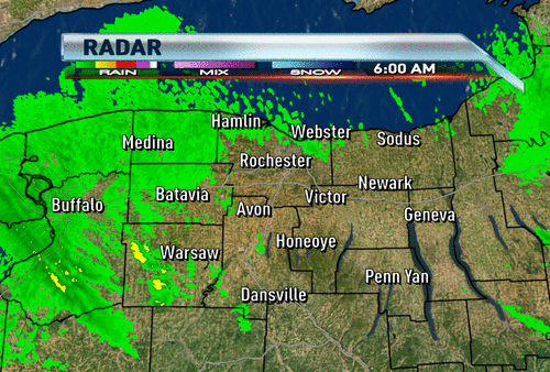
A couple of things are happening here. First thing you have to understand that the beam being transmitted by the radar in Buffalo (and surrounding locations) goes out in a straight line. Unfortunately, the earth is curved so as the earth curves away from the beam the beam goes higher in elevation. In situations like this lake effect snow event the beam will go over a lot of the snow that is falling closer to the surface of the earth. The snow also plays a role in not getting an accurate measurement on intensity. The snow is so small and so fine that if the radar beam reaches the snow it doesn't bounce back the energy as well.
When I worked in Erie we had a very similar problem. Neither the radars in Cleveland or Buffalo could detect highway closing lake effect snow because of the beam over shooting the top of the snow. If you went to any weather site that had a composite radar you would see snow near Cleveland and Buffalo and absolutely nothing in northwest Pennsylvania. Same thing applies here to Wayne county.
You'd think in the 2010, our government would have improved radar by now.
ReplyDeleteGreat info! Thanks :)
ReplyDeleteSunny in Victor.
ReplyDeleteBrian or Scott,
ReplyDeleteAccording to the latest NWS discussions, there's not going to be any Georgian Bay connection making it into Rochester metro tonight. They expect it to be near Buffalo. I thought tonight was going to be the more intense portion of this event for Rochester. Is that no longer the case?
HOW CAN THERE BE A GEORGIAN BAY CONNECTION IN BUFFALO? THE WINDS ARE NW. THAT DOES NOT MAKE SENSE.
ReplyDeleteTo the last comment, if you check the radar, that band is already about to shift past Buffalo moving toward the east. And looking upstream, the west to east shift of that Georgian Bay band continues even up into Canada. You could extrapolate that and conclude that it will slowly shift near our area later tonight. Also, since you're referencing the NWS, they also note that instablity will hold steady or even INCREASE across lake ontario tonight. That could mean more of what we just experienced, or maybe even worse, in my opinion.
ReplyDeleteYes, it does make sense. Georgian Bay is NW of Buffalo and a band of snow is orientating itself down in a line from NW to SE. The winds need to be somewhat more westerly for it to pivot into the Rochester metro.
ReplyDeleteIT STILL LOOKS LIKE THE NOREASTER WILL MISS US. SINCE IT IS A LA NINO YEAR HOW COME THE MODELS ARE NOT MOVING THIS STORM WEST LIKE EVERY OTHER STORM?
ReplyDeleteI'm also wondering about tonight/tomorrow morning...if the commute is any worse in the AM on Wednesday and RSCD doesn't cancel school I'll be fairly upset. I'm a teacher and if I were a parent I wouldn't send my child out on roads the way they were this morning. Having a snow day would be very inconvenient for me but come on now, when the meteorologist says, "If I didn't have to go anywhere, I wouldn't", I think we should pay attention.
ReplyDeleteWhere I live in gananda the schools were closed today.
ReplyDeleteWell said on the schools. I couldn't believe the city schools remained open. Roads were terrible, visibility was terrible. Wind chills were near zero. And the snow was expected to continue to pile up through the day. Have we set a new standard for how bad it needs to be to close schools? We're not Oswego, here.
ReplyDeleteI should also add that it's irresponsible to keep schools open with such bad road conditions. When even the main expressways are completely snow covered, you know the side roads are even worse. Calls have come in all day long for cars off the road, multiple vehicle accidents, cars disabled and blocking. Yes, let's put hundreds of school buses in the mix as well! Makes sense to me. (sarcasm). Let's just hope conditions don't deteriorate this afternoon so the buses can get the kids home safe.
ReplyDeleteThe only reason why they do not close the schools is because money is more important than the safety of our children. When a snow day is declared, the state backs off on school aid (funding) for that day.
ReplyDeleteI remember when I was going to school in the 70's, snow days were very common.
Snow has definitely picked up in the last 30 minutes in Irondequiot. getting kind of nasty out there again. Is the visibility and overall conditions starting to go downhill anywhere else?
ReplyDeleteI do not think this type of snow warrants a day off from school if you ask my opinion. Sorry!!!
ReplyDeleteThe snow will pick up tonight after sunset North of I-90 with many getting 6-12" again by morning. By the way, Rochester airport is fast approaching the all time record for snow in December. Keep in mind that we've NEVER recorded 50" of snow in December, that's about to end. I will show the numbers tonight.
ReplyDeleteScott Hetsko
such a tease you are Mr Hetsko! lol
ReplyDeleteAbout 8 or 9 inches of snow in the south part of Perinton, but places in town just north have around a foot of new snow if not more.
ReplyDeleteRoute 390 has been shut down from Ridge Rd all the way to 490. Numerous accidents and terrible roads. If you must drive, be very careful.
ReplyDeleteIt's not about the type of snow or the amounts, it's about the overall conditions (wind,visibility,temp,snowfall), and the conditions of the roads. Keep in mind a large percentage of students in the RCSD walk to school. Many others take RTS buses and have to wait for long periods of time on the sides of roads with cars slipping around. It's not about a day off school, it's about assessing the risk and making an educated decision. I think it's probably safe to say these decisions are made with money in mind, not safety...if safety was the sole factor, we'd assess that there are in fact life-threatening conditions, especially for ill-prepared teens, and realize that one day of school isn't worth risking just one kid...my humble opinion :)
ReplyDeleteScott,
ReplyDeleteDo you still feel as you did last night that the georgian bay connection will hit the metro, Brighton,Penfield,ER and Fairport villages from about 1am until 10am?
*one day OFF school isn't worth risking EVEN one kid. lol...maybe I could use an extra day of school.
ReplyDeleteJust got the latest number from the airport today. 11.2" since midnight bringing the monthly total to 44.2" which is number 3 on the all time list! We've NEVER seen 50" in 130 years of record keeping in Rochester. I expect at least 60" by the end of the month!
ReplyDeleteScott
Wow, that's incredible. And all this snow is really starting to add up. Police have shut down route 104 now too....in addition to 390. It's getting really bad out there.
ReplyDeleteCorrection from the airport. 6.2" since midnight which has us at 39.2" for the month. Still on our way to a record.
ReplyDeleteScott
Why dont they issue travel advisories and get people off the roads!
ReplyDelete104 is open right now
ReplyDeleteScott- is the doppler in Montague in the Tug Hill part of the composite that doesn't reflect Wayne County?
ReplyDeleteI agree with Charles. But then again, that might mean they have to close schools tomorrow...certainly don't want to do that. There's dollar signs at stake here!
ReplyDeleteyeah the roads are bad! stay off the roads!
ReplyDeleteScott
ReplyDeleteI know you busy looking at those impressive numbers for tonight and tom. and possible Noreaster next week but thoughts about what you felt last night. Georgian Bay connection lighting up metro, brighton, penfield,er and fairport?
Still expecting that band to drift Eastward later this evening. Not positive it will stay over us long but regardless 6-12" more tonight for many along and North of I-90.
ReplyDeleteScott
The lake effect band over near Buffalo is now on the east side of Buffalo and is now officially a lake ontario now band and no longer any of it crosses lake erie. Also it appears that the band along the shoreline is strengthening.
ReplyDeleteNoreaster will either go OTS or be far east to impact us we have to be thankful for lake O!
ReplyDeleteHave to believe if the forecast comes true there has be many school closings in monroe county tomorrow and the city district.
ReplyDeleteis the band coming from buffalo going to be stationary or going to be moving fast or stay in the Monroe county area over night?
ReplyDeleteQuick comment on the schools: Yes, it is true that state aid gets cut if kids aren't in school for at least 180 days. However, each school WILL get to 180 days, I assure you of that. It's a matter of what days...most districts around here schedule in three days...when those are used, pre-scheduled vacation time has to be used such as Memorial Day, April break. That often causes disruptions to families' vacation plans, etc. so the dists. try to avoid that if possible. The state funding dropoff for each day under 180 is steep.
ReplyDeleteWith or without radar, I can assure you it has been snowing hard in Wayne Co. all day north of Rt. 31. Several more inches in Sodus.
Scott - is Dec. going to turn out to be the one especially cold, snowy month that you predicted this winter?
I expect that band to strengthen from Georgian Bay for Rochester and the snow will transition to more "flakey" snow as the thermal profile becomes a bit milder which will increase dentritic snow growth in the cloud layer.
ReplyDeleteScott
...Monroe County...
ReplyDeleteCharlotte 10.0 440 PM 12/14 4 inches since 7 am
i don't know who or where they measured 10" in Charlotte? I live across the bridge in W. Irondequoit about 1/4 mi. south of L.Ontario and weve only seen about 4-5 inches. Just like the last storm. Very unusual for us. I hope the westward turn to the wind increases the intensity along the near south shore! As for the noreaster, 5 days out anything could happen, prob move westward or simply fall apart like the last one.
ReplyDeleteThe snow has stopped in the metro and surrounding suburbs! Not sure what happened and Scott is the LES done for these areas?
ReplyDeleteI'm so you posted your totals in W. Irondequoit Dave! I was starting to think I lived in a bubble here in Hilton. I keep seeing and hearing about the snow totals being so high all along the shore (even this way, according to the news maps), but we only have about 5 or 6 inches (and I think that may be a generous estimate.) I'm with you in hoping one of these storms will give US some snow!!
ReplyDeleteIt looks like there is now 2 defined lake bands one is halfway between Rochester and Buffalo and the other one is right over Buffalo
ReplyDeleteThe band is really coming closer! Also it seems to build up!
ReplyDeleteOne question:isn't it just moving over us eastward?!
Scott, do you think more schools are going to be closed tomorrow for example Brighton?
ReplyDeleteThat was supposed to read, "so glad you posted..." to Dave.
ReplyDeleteSNOW has stopped falling in N Greece, a very ominous feeling
ReplyDeleteJust wait till the band moves east and sits over monroe county in a couple of hours from now! HUGE SNOW
ReplyDeletei don't see any parameters that would allow that band to move further n.e. than the s.w. portion of Monroe county tonite. Scottsville and Churchville may get in on the action but I don't see the georgian bay connection affecting the south shore of monroe county or the metro until later tomorrow evening. The NWS mesoscales have drastically pulled back on snow totals for monroe county. Of course there will be that pure ontari band moveing on shore in mid and eastern wayne county. Why we never get that pure band I'll never understand. Why is marion different from Irondequoit??? I don't get it. DAVE dvdmw@aol.com
ReplyDeleteOh that band is coming east my friend...
ReplyDeleteFrom NWS
ReplyDeleteA MORE IMPRESSIVE BAND EXTENDED ACROSS WESTERN ORLEANS COUNTY NEAR
MEDINA TO BATAVIA AND EASTERN GENESEE COUNTY. THIS BAND HAD
SNOWFALL RATES OF ONE TO TWO INCHES PER HOUR WITHIN IT. BOTH BANDS
WILL SLOWLY MOVE EAST DURING THE 7:30 TO 9 PM TIME PERIOD.
I cant wait to see what the airport reports as it gets over the band. I am thinking that we will see 12 inch snow totals for the day from KROC (as of 4 PM it was already at 6 inches so only 6 more inches from 4 PM on)
ReplyDeleteIt looks like that even if the storm misses us next weekend then after that we may see some more heavy lake snows
ReplyDeleteWhere's the snow this evening????
ReplyDeleteAs winds are slowly veering, shear has disturbed the LES for now. That 1-2" per hour band will be worth watching the next couple of hours.
ReplyDeleteScott
NWS has increased snow forecasts for west Rochester to 6-10 inches overnight... that lake band sure is strong... I would love to get that over me just for a short time tonight
ReplyDeleteRandom question. Everytime a snowstorm hits we talk of snow days. Correct me if I wrong, but I believe school districts keep in contact with local meteorologists. What are the policies for calling a snow day? It just seemed ridiculous that a snow day was not called today. Granted, we didn't have the snow totals or windchill to 'qualify' but the roads were just plain ole dangerous. What do school offcials inquire to you guys regarding the weather?
ReplyDeleteCharles what do you think that the chances are for Newark getting another big dumping of LES tonight?
ReplyDeleteI'm noticing some "back building" of the lake band as it pushes slowly east. This tells me it may be trying to reconnect with the Georgian Bay band. Also looks like some slow intensification. Perhaps shear is becoming less of a factor at the moment.
ReplyDeleteAGAIN....This is SCOTT HETSKO'S BLOG. NOT Charles'. Please be respectful and ask the professional, experts about weather. Otherwise, communicate with Charles somewhere other than this blog. It's very rude and obnoxious.
ReplyDeleteThank you,
Dave
it would be best if you asked news 8 that question
ReplyDeleteI also agree with Dave that the biggest threat for heavy metro snow will probably be delayed until a WNW flow gets going tomorrow evening into early Thursday. It's coming I think but appears less likely that it will occur tonight.
ReplyDeleteScott
Great the metro will get very little again tonight. Doubt if it will even come tomorrow as Scott said it's coming I think. Do not understand your computer models had that band dipping in the metro area around 1am and hanging until 10am very confusing!
ReplyDeleteMade a new snowfall map to reflect what should occur through tomorrow morning. It will be on FOX at 10 p.m.
ReplyDeleteScott
How about us in Batavia Mr. Hetsko?? I can look out my window and see it snowing, but for how long?? I am wishing to get a whopper! I LOVE THIS WEATHER! :):)
ReplyDeleteGreat update the metro and suburbs around it get the shaft again! Tha same thing will happen tomorrow be happy with our 6 inches over 3 days and think we are getting a storm. So much for a snow day in the city. Not sure how things change that fast when the snow models showed that band going into the metro last night and today. But, Scott you were hot and do to miss a forecast.
ReplyDeleteWhat happened to the lake effect we were supposed to get tonight. SNow has completely stopped in Gananda. I thought wer were on our way to huge snow totals through Thursday. About 18 inches so far in Gananda.
ReplyDeleteWhere is the general LES in the metro?
ReplyDeleteBatavia looking good for additional snow overnight. Not so much for Rochester and Eastern burbs tonight. Better shot for them tomorrow evening and early Thursday.
ReplyDeleteScott
Oh well. Se la vee.
ReplyDeleteScott, what are the chances for a white christmas this year. Any terible chance it will wamr up next week?
ReplyDeleteThanks for your answer! I watched at ten too! :) Fingers crossed in Batavia for a snow day! Ready for hot chocolate with the kiddos! :)
ReplyDeleteWhite Christmas looks strong. No real big warm ups in the next 10 days. Bing Crosby may not have to dream.
ReplyDeleteGood night all
Scott
Once again for the majority this whole storm and LES event was a bust! The whole winter will be disappointing but oh well in the scheme of things who really cares
ReplyDeletewow we just got about 1-2 inches total tonight! :o instead of 6-12"! But acctually scott posted it yesterday so the forcast was allright...
ReplyDeleteScott how much would you expect for the next night? (Penfield)
Monroe county is out of the lake effect snow warning. What happened to the big lake snows we are supposed to get later tonight?????The NWS has 1-3 inches for us. What the heck happend???
ReplyDeleteKW at news 10 has really went down hill at becoming an accurate weather guy. Even last night when Scott had the knowledge and future vision to see that the big snows were not going to hit the metro KW still said it was coming in the morning and it would be a rough commute. Scott changed his forecast and KW just kept his inaccurate one! You would think with his experience and knowledge about the dynamics of Rochester weather he would be more accurate. He has become poor maybe he should spend less time disproving the global warming theory and focus on getting back to being Rochester's most accurate forecaster like he used to be!
ReplyDeleteI agree. He and all of channel 10 has gone down hill as far as accuracy. Although where I live in Gananda it was snowing hard this morning and the road were terrible in that area, but overall he was wrong and has been lately.
ReplyDeleteTo the one person who asked what happened to the big snows we are going to get tonight? I don't know what you are talking about. From all the forecasts I have seen from Scott, and those that I have done I do not recall any of us calling for big snow tonight. The original Lake Effect Warning was only for 4pm today anyway. -Brian
ReplyDeletehE SAID LAST NIGHT THE THE BIG SNOWS WOULD NOT HIT LAST NIGHT AND THAT THEY WILL STILL HIT BUT DELAYED. HE SAID THAT ON THE 10PM NEWS LAST NIGHT.
ReplyDeleteFor those who are not aware... YOU ONLY TYPE IN CAPS WHEN YOU WANT TO COME ACROSS AS SHOUTING! And this is only weather we're talking about... so is shouting really necessary? Food for thought :)
ReplyDeleteSorry, not yelling, but Scott did say last night at 10 and 11 that the heavier lake effect for Monroe County would be delayed until tonight. He was referring to the Georgian Bay connection. He said another 6-12 could fall by Thursday morning.
ReplyDeleteI still think we will see some kind of connection with the Georgian Bay tonight. I agree with that. I am not going 1-3 as you said the NWS was. We will have to watch that. Given what is going on now and the temperatures not as cold I went with 2-4 with around 3-6+ in Wayne county.
ReplyDeleteAlso I have done a new blog update. -Brian
The CAPS person is right, I did say the potential is there for bigger snow tonight and early Thursday and I still do think it's possible. Not for everyone but city North and East along Route 104 and Wayne County. Locally significant snow will fall in these areas tonight. 500 mb vort will spin in overnight which has a history of enhancing snow for a time.
ReplyDeleteI'm glad I pulled back last night though. Let's see some new data and assess tonight's weather this afternoon.
Scott Hetsko
I'm very worried that Wayne county will beat our record on Saturday for the longest with out snow (we tie with the record Friday) and the county got that record in the early 1930's.
ReplyDeleteYou actually make it seem so easy along with your presentation however I find this topic to be actually
ReplyDeletesomething that I think I might by no means understand.
It sort of feels too complex and extremely wide for me.
I am having a look forward for your next post,
I will attempt to get the cling of it!
Here is my blog post :: automotive internet marketing
I every time emailed this webpage post page to all my friends, because
ReplyDeleteif like to read it next my friends will too.
Feel free to visit my weblog :: work at home data entry
you are really a good webmaster. The website
ReplyDeleteloading speed is incredible. It sort of feels that you're doing any unique trick. Also, The contents are masterpiece. you have done a magnificent activity on this matter!
My blog - yellow pages ad for appliance repair Dunedin FL