Written By: Scott Hetsko
(9:00 PM update)
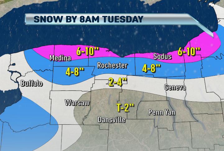
You know me, I think it makes most sense to break up these lake snow forecasts in 12-24 hours chunks. Here's the first of what will be many map this week as lake snows are already increasing as Arctic air pours South.
Light to moderate snow continues to fall from 1/2 to 1" per hour near and along the Route 104 corridor. Many towns here could wake up to 10" of powdery snow!
:)
ReplyDeleteTemperatures have really fallen today ... some areas already in the single digits with wind chills below zero. Do you think they may need to issue a wind chill advisory for tonight and tomorrow?
ReplyDeleteNWS has dropped the heavy snow out of the Wayne county forecast for overnight
ReplyDeleteThey also dropped snow accumulations from 5-9 inches overnight to 3-7 inches
ReplyDeleteYou're better off not going by their "point and click" forecasts on the NWS website. They tend to change more frequently. The NWS forecast discussion and their Warnings will be unchanged.
ReplyDeleteYea but see everywhere in Wayne county and Monroe county at that has been lowered in snowfall forecasts.
ReplyDelete12 degrees on car thermometer in Gates.
ReplyDeleteMy forecast is overnight through noon Tuesday. Please keep that in your mind and 4-8" doesn't mean everyone get 8"!
ReplyDeleteScott
It's going to be another long lake effect week with some areas not getting theirs under tomorrow night and Wednesday. As for wind chill advisories, the numbers are close to their criteria.
ReplyDeleteScott,
ReplyDeleteWith 850 mb temps as cold as they are, is there a risk of the dendritic growth region reducing to the point where it lowers snow totals from where they are current forecasted, or do you feel that we are safe in that area for good dendritic growth throughout?
Nope actually I published the wrong image draft from earlier this afternoon. BUFKIT profiles suggest pretty good dentritic growth so I'm not too worried. I do think that short fetch tonight may hurt and could hurt my forecast for areas South of the city. However once Georgian Bay gets connnected tomorrow night and Wednesday, then the flakes may really fly!
ReplyDeleteScott
Heavy snow in Ontario NY
ReplyDeleteKeep those reports coming about your town, radar has a hard time seeing snow especially in temperatures this cold.
ReplyDeleteScott
Location: Browncroft and Merchants (extreme eastern city of Rochester):
ReplyDeleteBeen in a lull for the last hour or so, but the snow is just now beginning to fall again. Mostly light, but wind really whipping around. I can see dark clouds growing directly north.
Gates has been exactly like what East Sider said!
ReplyDeleteTown of Sodus, moderate to heavy snow falling for the past 3-4 hours. Plows are out, roads look slick. Be careful in Northern Wayne tonight.
ReplyDeleteNWS was talking about how the heaviest snows will not be north of 104 tonight do you agree Scott?
ReplyDeletenorth greece/charlotte, Heavy snow
ReplyDeleteIncreasing winds will indeed push bands further South for awhile overnight which means the city and points South may see an increase in rates overnight. You snow may fall heavy at times this evening Charles which would give you 4"+
ReplyDeleteScott
I already have almost an inch so I think that 4+ is a definite.. also I am south of 104 in your 6+ area I just was wondering about the lake snows being heaviest south tonight and not north
ReplyDeleteI placed those higher amounts there in anticipation of increasing wind speeds aloft tonight.
ReplyDeleteScott what do you think Fairport and East Rochester will get heavy snow?
ReplyDeleteIf winds do not increase as much as possible (just a question to increase my understanding of lake effect snow) then would the lakeshore areas get more like 8-12 inches?
ReplyDeleteI meant as forecasted not as possible
ReplyDeleteIs that a connection forming across lake Ontario on radar?
ReplyDeleteAny word on the storm for Sunday/Monday? Looks like its too far east, but as weve seen over the last year, storms end up moving west as the models and days get closer.... Any opinions on that storm?
ReplyDeleteMy opinion is: Wait. No one will know where that storm will go. I think that news 8 will agree with me here
ReplyDeleteModerate to heavy snow in the last hour 1/2 in NE Webster.
ReplyDeleteSo far, Sodus Point is not missing out like last week. Already 4" on the ground and still snowing fairly hard.
ReplyDeleteSend me some pics!
ReplyDeleteshetsko@wroctv.com
Thanks,
Scott
Light to moderat snowfall in Penfield! 10 min. ago it nearly stopped!? Before that we already had pretty heavy snowfall! The next days look interesting! Scott do you thing there might be some school closings tommorrow? I am more thinking about the windchill then about snow. ;)
ReplyDeleteThanks. (and if you answer what windchills are you expecting?)
Probably not for cold but maybe in your area for snow Wednesday a.m. Last week we had very few delays or cancellations.
ReplyDeleteScott
here in Ontario we already have 2 inches of snow here
ReplyDeleteScott i sent you a pic from Charlotte
ReplyDeleteNobody's radar is showing much going on out here in Wayne county (not sure why that happens sometimes) but I'm here to tell ya, It's really coming down hard right now in the Sodus Marion area. A solid 3 inches in the last hour.
ReplyDeleteIn South Greece we've gotten 2 inches so far. Moderate to heavy snow at this time depending on when you look out the window :)
ReplyDeleteAll the experts seem to target tomorrow night into Weds. morning for a strong band connected with georgian bay that will hit the city,fairport,er and penfield for a good 8 hours. Is that correct Scott?
ReplyDeleteI can confirm what Chris is stating in the Sodus area as I live in Sodus as well. Since the snow started around 1 pm, there is a solid 4-5 inches of light fluffy snow. Still snowing here.
ReplyDeleteScott,
ReplyDeleteYou may need to up your totals through tomorrow morning. It is REALLY coming down across the city. I picked up over 2" just in the last hour and a half. I live on the east side.
I am in canandaigua and only a trace here. Hoping for more though. :)
ReplyDeleteThey really need to put a Radar in ROC. The buffalo beam is shooting right over the Lake effect tops
ReplyDeleteIn Gananda. Snowing on and off Light to Moderate. About 2 inches so far.
ReplyDeleteMore off than on in Gananda. Nothing too impressive so far.
ReplyDeleteI agree with Richie, what would have to happen to make radar in Rochester a reality?
ReplyDeleteBuffalo, Montague and Binghamton are showing nothing for Wayne county. Not the case though, her in Marion. Snowing at a pretty good rate right now. 4 to 5 inches I would say so far. That's what's in the driveway anyway's.
ReplyDeleteEven a TDWR radar at Roc airport would do the trick
ReplyDeleteAt one point, there was discussion about putting the radar in Batavia (which would be directly between Rochester and Buffalo). For whatever reason, they didn't end up putting it there. It remains just off the thruway at the Buffalo airport.
ReplyDeleteScott,
ReplyDeleteWe're up to 3.5" on the east side of the city. I'm seeing a half foot by midnight easily. Snowfall rates are intense right now.
my last check was it coming down at about 1/2 inch per hour in Newark
ReplyDeleteJust came from Newark to Ontario via 31, 21, 104. 31 was wet, 21 got slick 3 miles N of Palmyra. Patches of diminished visibility due to blowing/drifting. 3"+ in NE Ontario. Steady light LES with intermittent bursts. 14 degrees F.
ReplyDeleteJohn, Thats a good report. I might be driving from Newark to RGH later tonight.
ReplyDeleteScott
ReplyDeleteAre you around or are you buried in data looking at the latest impressive amounts that will come from this LES event. And am I right that all the forecasters have targeted a time from about 1am Wednesday morning until about 10am where a strong georgian bay connection will pound the City,Brighton,ER and Penfield?
This is going to be quite impressive late tomorrow night into Wed. Cant really wait...I love this stuff. Still learning how to read the models though
ReplyDeleteYep you're right about tomorrow night for the city and East side burbs. 12"+ just between 9p and 9a Tuesday night into early Wednesday for the metro area. I will tweak that forecast tomorrow evening but I do suspect a WNW flow with slower winds and 850mb temps perfect for heavy LES
ReplyDeleteScott
As for radar, I agree. We could use a radar here in the Rochester area or even Western Wayne CTY. This type of LES is so fine, you have to be within 50-70 miles of the radar or else the LES lives to low for the beam.
ReplyDeleteUpgrades to all NWS radars are coming in the next few years. Dual Polarization Radar!
Scott
I live in Orleans county between Holley and Kendall and we have about 8"+ since noon today and its not letting up.
ReplyDeleteGilbert watch the "dark spots" on 21 S of Marion and between Marion and Williamson. Prevailing wind is in your face (windshield)- 31 to 490 may be safer if LES bands set up along the 104 corridor. Plows are out, but the North and Central Wayne County roadways are snow covered, and the shoulders through there aren't easy to distinguish with the snow/wind. I am estimating 1/2"/hour at present here. (1/4 mile S, 1/2 mile East of Bear Creek Harbor.
ReplyDeleteYep based on what I'm hearing from all of you, I'll post a new snow forecast through tomorrow morning. Hang in there, it will be up soon!
ReplyDeleteScott
What is the fluff factor (snow ratio) being its like 10 Degrees out???
ReplyDeleteim very disapointed that livonia will not be getting any of the snow that everyone else is getting :o( scott your my favorite weatherman and have been since you started! keep up the good work of the snow forecasts !
ReplyDeleteWow this lake effect is really pretty bad! Its snowing heavy in Penfield! The street conditions are bad! New snow about 2 1/2 inches.
ReplyDeleteThanks for the update Scott!:)
ReplyDeleteRatio at 10F is about 30 to 35" per 1" liquid equivalent. Sorry to my Livonia friend but I do appreciate your compliment! Drive North and hang out with us in the snow.
ReplyDeleteScott
The snow here in Fairport is beautiful powdery snow. We have at least 3 inches already and its been coming down hard for hours now.
ReplyDeleteIt is good see there are so many fellow weather geeks out there. :) Love this blog!
ReplyDeleteI love weather! Thats all I ever do is keep tabs on it! =]
ReplyDeleteI love the weather also...not real fond of driving in the mess...but I love to see it happen....
ReplyDeleteGlad so many of you have discovered our blog! We are really excited to get all these reports. Looks like snow is dropping further South now as steering winds are slowly increasing.
ReplyDeleteScott
Whoops, that's me Scott Not Brian.
ReplyDelete4 maybe 5 inches of snow in Perinton.
ReplyDeleteScott,
ReplyDeleteDo you know how much KROC has officially picked up yet?
They won't report until morning so I don't know what the airport has yet. I do think we'll be in record territory for the month by Friday.
ReplyDeleteScott
4-5 inches of snow in Ontario right now and still snowing pretty good
ReplyDeleteKROC just came out with a new update on current conditions and they are still getting heavy snow.. if they got a whole hour+ of heavy snow we could get a good snow total at the airport come morning
ReplyDeleteSnow still coming down like crazy. Wind picking up as well. Visibility is terrible. I'd be surprised if Rochester City Schools are open Tuesday morning.
ReplyDelete12" in Gananda. Schools are closed. Victor has about 1 inch. Amazing stuff.
ReplyDelete...MONROE COUNTY...
ReplyDeleteROCHESTER AIRPORT 10.1 655 AM 12/14 ROCHESTER AIRPORT
CHARLOTTE 6.0 700 AM 12/14 COOP
Surprised city schools are open today. Especially since forecasters are not predicting things will be better during the day.
ReplyDeleteStill snowing in Ontario, NY. Look at that band south of Buffalo, NY
ReplyDeleteWho cares about Buffalo.
ReplyDeleteWoke up to about 6-7" here in the Point. Sustained winds of 25-30 mph at the lighthouse, so more snow may have fallen than the above measurement but is being blown around. Two foot drifts on lee side of buildings.
ReplyDeleteProps to my boys in the weather office. Spot-on forecasting again! We got about 6 inches of snow in Penfield. In my humble opinion, schools should have been shutdown here, but what do I know--I am a sports guy...three days and counting before I trek south to Miami for Bills game---ahhhh! Way to go Scottie, Brian and Bob....like the old Oakland Raiders motto: Commitment to Excellence! P.S.--kudos to those who post here using their names...
ReplyDeleteThis comment has been removed by the author.
ReplyDeleteWe're on the shore of Lake Ontario north of Hilton and can still see the grass. The sustained high winds must be blowing the snow right past us! YAY.
ReplyDeleteYour weather forecast on TV tonight said it will be 113 next Thurs. Guess we'll have to turn on the AC. Ha Ha
ReplyDelete