
FOCUSING ON TUESDAY
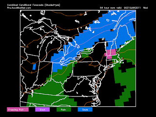
Bringing back the attention to Tuesday. I want to start by saying that this is NOT going to be a major storm... yet again. Our forecasting headache will be due to the possibility for the mix of precipitation. At left is the NAM forecast for late Tuesday and you can see that we fall right on the line between rain/snow. I've been watching this all week, and there has been very little support for freezing rain or sleet, but I can't rule it out at this point. If you look very closely, you can see the overlayed orange lines showing the 850mb zero just south of our area. With a slight southwest wind in the upper levels, it could be enough warm air advection to allow for the freezing rain possibility during the day/night Tuesday. By the overnight hours and into Wednesday, it'll drop cold enough to the point where snow is the only type of precip, with a few new inches on the ground for the middle of the week. An additional 1-2" of snow will likely follow on Wednesday as well. Although the details are still pretty fuzzy right now, I'd put 6-8" on the upper end of estimates at this point, but would lower those quite a bit once I see support for a more extended period of non-snow. Remember that when you're that warm (near or even above freezing) that the snow becomes much more dense and slushy, and thus the numbers aren't as high.
Okay Bob and fellow readers, I was definitely WRONG on the call for significant snow in Rochester this weekend. Gotta man up and admit it. Looks like a nice shot of LES in Wayne county though. I'm sure all those snow mobilers are enjoying it out that way.
ReplyDeleteDk, that band did touch Northern Monroe this morning for about an hour. I was out plowing and we get 2-3 inches on snow in 45min in Greece, Iroq. Webster.
ReplyDeleteBob.. 6-8" inches for this storm Tuesday? Am I reading that right?
Bob, do you see any chance of just plain rain? Or will everything fall in some sort of a winter precip?
ReplyDeleteI missed that shot of snow early today, but I drove along the lake this afternoon. Very dark clouds hovered over the lake all day. It looked similar to thunderstorm clouds. Very neat stuff. Regardless of whether you like cold and snow, you've got to just sit back and be in awe by the science of our weather in the Great Lakes. It's humbling.
ReplyDeleteBack to the mid week event, it looks like with the "thaw" being so brief, and then more snow and cold to follow, our snow pack is going to get very deep. As is, the snow is a good 6 to 10 inches deep for most place. Probably a heck of a lot more than that in eastern Wayne county. It's been awhile since we've hung on to our snowpack for such a long time. I'm enjoying it. The slightly milder temps on Tuesday will only help ripen the snow rather than actually truly melt it.
DK, whats your take on this storm Tuesday? As far as accumulations if any?
ReplyDeleteAlso, did you look at the GFS today for next weekend. Pretty impressive, I know its 2 weeks away but wow.
I like Bob's totals. Not really impressed by Tuesday itself. Just a lot of slop falling from the sky. Looks like a decent amount of snow will put us right back where we were before the mini thaw snowpack-wise.
ReplyDeleteI'd like to believe the GFS for two weeks out, but that model always gives WNY a blizzard between hour 324 and 384. If it EVER came to reality i'd maybe put more stock into it. But, unfortunately, it never does. I've learned not to get too excited about things two weeks out. Too many disappointments.
I know, I was just looking at it..... 6"- 8" inches? Starting when and ending when?
ReplyDeleteThat would be a nice amount to add! I know it is colder than a well diggers ass outside right now! I am interested to know at what time this snow is going to start. I didnt think we were going to get anything but flurries out of it...
ReplyDeleteI forgot to ask this question on my last post, on the above map, i see the large area of just black. Does that represent no precip for that area or is this just a map for the temps? Stupid, I know, but I am still learning the maps and such.
ReplyDeleteI know Chris, that is why im kinda shocked by the 6-8inch number.
ReplyDeleteYeah kind of wierd. I have been bouncing around on TWC and Accuweather (or InAccurate Weather). TWC says no big deal and AC.W says Ice for us and snow. As always, I trust the Fox/8 team!
ReplyDeleteThere is no way 6-8 on the event mid week not sure what Bob is talking about.
ReplyDeleteAndrew, your way too negative man and clearly not completely reading what Bob said. He said 6-8 inches on the upper end if the majority of the precip is snow. And that he would lower them quite a bit if he sees better model agreement for a prolonged period of warm air... Come on man!
ReplyDeleteWell the great forecaster never even came close to mentioning 6-8 on his weather cast. So not being negative just keeping it real. The weather here will be realitively quiet the next several weeks.
ReplyDeleteI think Bob's snowfall amounts (6-8) are reasonable. What's going to happen is, as the cold air returns later Tuesday night into Wednesday, a surge of moisture will be overrunning the cold air as it deepens over our area. This will likely lead to a widespread snowfall lasting late Tue or Early Wed, through the day Wed, followed by some lake enhancement / effect later Wednesday and Thursday as the cold air deepens further. 6-8 inches can happen easily in this setup, if it were to pan out. And the models suggest it will. That's why I think that despite our brief, 1 day thaw on Tuesday, we may end up with an even deeper snow depth by a day or two after the thaw than we do now.
ReplyDeleteWhere would the 6-8 come from? Albany looks to get 8-12 from this. Other channels are calling for basically nothing with precip and minimal snow through the week.
ReplyDeleteI think lake snow is what he means. The usual north of 90 and the 104 stretch.
ReplyDelete