
ANOTHER BIG MISS FOR ROCHESTER
Written By: Scott Hetsko
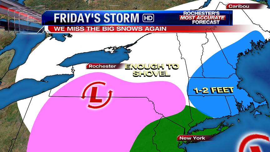
Good afternoon storm lovers! A fairly strong upper air low will merge with a coastal storm on Friday morning. This combo will produce very heavy snow and wind for interior sections of New England Friday afternoon through early Saturday. For us, the potential is there for a plowable snow fall (3-7") most of which may occur with warm air advection late Thursday night into Friday.. The initial low will throw in enough warm air aloft to cause a mix of sleet for a time early Friday before temperatures grow colder in the afternoon and night.
If you're hoping for lake enhancement, I don't see it. The coastal low's influence will be too far away to produce much early Saturday. Snow showers to sunshine for Saturday and a beautiful Sunday on the way too. Looks like you should drive 6 hours East if you want to enjoy a big snow this time around!
Thanks!
Scott do you see New York City getting in on any bad weather Friday AM. I have a connecting flight through JFK around 9AM.
ReplyDeleteSCOTT, THIS TIME AROUND???? THAT IS ALWAYS THE CASE. WE ALWAYS MISS OUT. Another dissappointment in several years of disappointments.
ReplyDeleteJanuary 1966 (twice)
DeleteMarch 1993
January 1996
March 1999 (twice)
February 2007
Shall I go on? These are just the most notable examples. Now knock off the melodrama.
shut up, Macedon.
DeleteWow, your back!!!
DeleteYes JFK will have delays connecting due rain or mix there but also due to other locales in the Northeast.
ReplyDeleteScott, it looks like the it will get sloppier as one goes further south... Any thoughts on how quickly that line will grade from mostly snow to sloppy mix? (i.e., are we talking about mostly snow with some sleet in the Finger Lakes and more sleet as you move toward the PA line? Or are we likely to see a lot of sleet even in the southern parts of Greater Rochester?
ReplyDeleteThanks Scott, I am so glad to see your view on this. You are always the most accurate in forecasting. Have a nice day :)
ReplyDeleteWinter Storm Watch fresh off the presses. 9 to 18 inches?!
ReplyDeletehttp://forecast.weather.gov/showsigwx.php?warnzone=NYZ003&warncounty=NYC055&firewxzone=NYZ003&local_place1=&product1=Winter+Storm+Watch
Personally I think that's way too high.
Yeah I hold more faith in Scotts forecast.
DeleteRegardless it will be nice to get some snow.
Andy
Scott,
ReplyDeleteWhat is the NWS seeing that you are not? A foot and a half? Really!?
Signed,
Confused
I'm as confused by their forecast as you. I don't see it here, 4-8" at most in my opinion at this point.
ReplyDeleteI believe the word we are looking for here is "refer"
ReplyDeleteI'd love to know who issued this forecast. I bet you'll see it change tomorrow.
ReplyDeleteI believe it was Macedon.
DeleteKind of funny i hace to go with locals seeibg they r all un same range nws is nuts
ReplyDeleteLets set up a way to gamble on snowfall totals! That will make this blog really fun and make Anon put his money where his month is....
ReplyDeleteI would do this
DeleteGood to hear from you Scottie! I'm with you on the 3-7 but don't take it personally that I hope you're (we're) wrong.
ReplyDeleteI don't know where the NWS got those numbers, but it still looks like we should see some decent snow. And Valentines Day looks interesting (looks similar to 2007), but that is still a ways out. Enjoy the snow everyone!
ReplyDeleteThis is all I can gather in there discussion to suggest heavy snow...
ReplyDeletePRECIP SHOULD STAY ENTIRELY SNOW AS THE SURFACE LOW TRACKS
JUST SOUTH OF THE NY/PA BORDER FRIDAY AND FRIDAY NIGHT...PLACING THE
FORECAST AREA IN A DEFORMATION BAND THAT COULD BRING SIGNIFICANT
ACCUMULATIONS OF SNOW. A WINTER STORM WATCH HAS BEEN ISSUED FOR THE
ENTIRE FORECAST AREA AS A RESULT.
NAM has initial low 70 miles further North which makes more sense to me given history of upper air vorts with similar steering winds in the past. You can't forecast on ONE MODEL!!!
ReplyDeleteDoes that change your forecast scott?
ReplyDeleteAgreed Scott. Who knows how this thing is going to play out. Might not know till it happens.....
ReplyDeleteI won't amend my thoughts until I see a compelling reason TO change it. Not until I see 12Z data and a consensus...
ReplyDeleteAlso I like history A LOT more than models...FORECAST models I mean. Actual models I enjoy! :)
ReplyDeleteGo check out the Brazilian model posted from time to time on the AccuWeather forums. I think you'll be pleased XD
DeleteEvery county in the state has a Winter Storm Watch right now. The last time that happened was before the famous Groundhog Day Blizzard that struck Chicago hard, with a lesser but still significant impact here.
ReplyDeleteOne thing we can be entirely sure of...someone on this blog will label the storm a bust no matter what happens.
ReplyDeleteLOL now that's for sure!
DeleteI am confused. The NWS is talking about 9-18".
ReplyDeleteACCUMULATIONS...UP TO 2 INCHES OVERNIGHT THURSDAY NIGHT...5 TO
10 INCHES FRIDAY...4 TO 7 INCHES FRIDAY NIGHT...AND AN INCH OR
LESS SATURDAY...LEADING TO STORM TOTALS OF POTENTIALLY 9 TO 18
INCHES.
The storm is a bust.... we will get 1/2 inch of snow :) LOL joking
ReplyDeleteBringing the snowblower out of retirement! Yee-haw!!! Glad to see that you are alive Scott (as it pertains to the blog anyways). BTW, where is the douche who is always crying about a early spring?? Seems to be quiet for the moment.
ReplyDeleteHoping for slamarama
SREF mean is around 15 inches total. I think that's where the NWS is getting their high numbers from. I also think the SREFs are significantly overdone.
ReplyDeletehttp://www.spc.noaa.gov/exper/sref/fplumes/index.php?YMD=20130206&RT=15&PRM=Total-SNO&SID=ROC&INC=ALL&NNC=&max=&min=&mZOOM=7&mLAT=42.20385629980137&mLON=-76.68224013671875&mTYP=roadmap
Now we just need to root for Member ARN1 to verify XD
you said member
Deleteshut up dill weed
DeleteI am the great cornholio
DeleteWhat amazes me the most about this whole ordeal is that it's occurring with precisely zero blocking near Greenland. We wouldn't be talking about a big New England storm right now if not for two disturbances each traveling at the perfect speed to meet in the perfect spot to cause a potentially historic storm to occur. This type of thing doesn't occur very often even WITH a blocking pattern keeping the jet stream in place, so it's easy to see how vastly improbable it is when the jet stream position is constantly changing like it has been lately.
ReplyDeleteI am here anon 7:12. Are you riding on the Boston coat tails now? Becuse you live in Rochester and we will see a few inches and then look at the weekend temperatures and early next week? The few inches will be gone by Monday and then spring like so keepa quiet anon 7:12.
ReplyDeleteBoy you are delusional aren't you?
Deletehttp://forecast.weather.gov/MapClick.php?zoneid=NYZ003
"Tuesday: Mostly cloudy with a 40 percent chance of snow. Highs in the mid 30s."
"Tuesday Night: Mostly cloudy with a 30 percent chance of snow. Lows in the upper 20s."
"Wednesday: Mostly cloudy with a 30 percent chance of snow. Highs in the mid 30s."
Springlike indeed...
I was actually out watering my lawn today, getting dry out there with all the sun and warm temps.
ReplyDeletehaha! My lawn still covered by snow.
ReplyDeleteDavid you are actually good with your knowledge. What do you think we will get from this storm?
ReplyDeleteOmg, you guys are cracking me up! I don't have great bladder control in the first place so thank heavens for my depends. Bring on the snow!
ReplyDeleteTo be honest, I have no idea on this storm..... Im going to sit back and be a spectator.... If I had to guess, 4-8 sounds right... I don't get what the NWS is saying right now.... Maybe they see something we dont..... Magic 8 ball
ReplyDeleteThe updated watch text says 6-11 inches. Far more reasonable than their asinine prediction from earlier.
DeleteThat seem more reasonable.... Whatever they were smoking this evening, I want some..
DeleteHey spring fling! I would agree with you on the whole "early spring" thing, but then we would both be wrong.
ReplyDeleteI'll be here all week....
6-11 is way too high. We will be lucky to see 2-4. Winter storm watched will be dropped by tomorrow morning or afternoon and changed to a winter weather advisory, guranteed. We will be spectators to a BIG storm once again. The energy will transfer quickly and we will be left in the dry.
ReplyDeleteWhere the hell do you keep drawing this level of negativity from? The mood here was so great then you decided to spill your bucket of tears all over the place. Guaranteed eh? Okay I'll hold you to that Nostradamus but don't count on it happening. I bet you'll be that one guy to call the storm a bust no matter what happens. In the meantime, keep the pessimistic exaggerations to yourself.
DeleteI guess you think Scott is being negative since he just said that it will not be a big deal for us and that 3-6 is all we will get. I guess he is being negative to by telling the truth. 3-6 is only advisory level snow. That is a fact my friend.
DeleteDo you need me to fine tune those strings on your violin........
ReplyDeleteNope. I am used to this so it does not surprise me in the least. Boston could see over 2 ft while we will see 3-6 at most. Boston could see more snow in this 1 storm than we have seen all year.
ReplyDeleteYou really think Boston's gonna see over 3 feet? Their biggest storm ever is 28 inches, try again buddy.
DeleteI guess you are not reading the chatter out of Boston and other stations. Yes, they are saying it is possible they could see 3ft of snow. Just because that has never hapend before means it could not happen. Really?
DeleteLOL David--- I'm glad I don't read Macedon posts while I'm driving, or I'd be tempted to jerk the wheel into a bridge abutment.
ReplyDeleteI'll be happy with whatever we get.
Andy
I will be too. Whatever happens happens. Seems like SOME PEOPLE here won't be happy unless they get the lollipop zone of some monster fantasy blizzard.
DeleteSo you would be happy with 3-4 inches. Wow!!!!!
DeleteHahahahahahahahahaha
DeleteHahahahahahahahahah. I can do that to. LOL
DeleteNot sure what is so funny? They are saying Boston could see up to 3 ft of snow. We have had 36" so far. MMMMMM. Do the math. 3x12= 36". Like I said Boston could see more snow in 1 storm than we have see all winter.
ReplyDeleteBoston isn't going to see 3 feet of snow. Period. Even the SREF mean, which is amping snow totals too much for everyone, gives Boston 30 inches. That's the high end of the deal, most likely they'll see 18-24 inches maybe SLIGHTLY more. You may resume cutting your wrists now.
DeleteOr waterboarding....
DeleteWe will see ANON. We will see. Too funny.
DeleteLets open up the lines!!!!
ReplyDelete0" 50-1
0" to 2" 40-1
3" to 6" 4-1
7" to 10" 3-2
11" to 14" 17-1
15"+ 35-1
im throwing a sawbuck on 17-1
DeletePlaying it safe and going with 3-2. If the odds for anything less than 2 inches are beat I say we each give Macedon an Applebees coupon and a pamphlet on tear collecting.
DeleteLOL. I love Applebees.
DeleteAnd crying, don't forget crying.
DeleteI just shed a tear.
Deletegive me $50 on 4-1
DeleteMy money is on 4-8" generally around here.
ReplyDeleteWatch out Scott, they may think you are being negative by telling the truth. LOL
DeleteScott... Idea for next year. For all the main snow events, we can set up some type of pool. Where a certain amount of points is awarded if you guess a certain snowfall range for a advertised snow event. For example...
Delete0-1" 10pts
2-4" 8pts
5-8" 6pts
9-12" 4pts
13-15" 6pts
16-18" 8pts
19" + 10pts
Something like that..... Then we keep score, and the person with the most points at the end of the year can get like a tour of the news studio.... Could be fun....
Macedon you said we would get 2-4 tops, you have no right to talk about "telling the truth."
DeleteI am sticking with 2-4. Scott said 4-8. If we get 4 that is Scotts low range and my high range. He is the expert. I am just guessing.
Delete0z GFS is a good deal further east with the coastal low, keeping the heaviest precip amounts offshore. Boston still gets thumped with 18 inches. Our region would do just fine as well. Now if only the weather played out exactly as single model runs indicated...
ReplyDelete0z Euro has 1"-1.25" of QPF here, I assume the vast majority is snow.
ReplyDeleteWhat site do you get that Euro info? I can never find it. Thanks
DeleteEven though I'm flipping exhausted I can already anticipate what I'll see when I view the blog tomorrow, so I'll just get it out of the way now to spare our troll the effort:
ReplyDelete"You can throw your stupid models out all you want they're always wrong. We are getting a few inches tops no big deal for Rochester then it's on to spring with highs in the 40s early next week."
I believe we are in a winter storm warning now? That is not usually issued unless they are pretty positive you get at least 8 inches of snow? I felt 6-10 the other day and I still stand by that happening with periods of heavy snow tomorrow. That is what I see but I am no expert.
ReplyDeleteI think channel 8 may be too low on their forecast now. The NWS has us in 8-12 as well as other channels. They all state the mix will stay south of us.
ReplyDeleteNws also had us at 18 inches yesterday until tonight we may not really know
ReplyDeleteAnother channel has 1-2 tonight, 6-12 tomorrow with more near the lake. They state as well as the NWS that there will be some lake enhancement with this. I know Scott stated that there would not be yesterday. We will see.
ReplyDeleteI am wondering the same thing. John had 4-8 totals this morning. Not sure wht winter strom warning if that is the case.The next GFS should tell a lot you would think.
ReplyDeleteSpring time troll-get that apple out of your mouth (like the pig that you are) and utilize your mush for brains!
ReplyDeleteSeems to me you have really buried yourself in your little cave this time!
Love ya like a brother!
WINTER STORM WARNINGS RULE!!
I know some of you follow NOAA forcast discussion. But for those that don't, you may find this somewhat interesting. Oh yea, early spring, that idea is dead!
ReplyDeleteFORECAST CONFIDENCE IN HEAVY SNOW HAS INCREASED AS A RESULT OF THE
00Z MODEL GUIDANCE...HOWEVER SOME SIGNIFICANT AREAS OF UNCERTAINTY
REMAIN. SURFACE LOW PRESSURE WILL LIFT ACROSS THE OHIO VALLEY
THURSDAY NIGHT...AND THEN WILL TRANSFER ITS ENERGY TO A DEEPENING
COASTAL LOW ON FRIDAY AS AN UPPER LEVEL SHORTWAVE PHASES WITH A
COASTAL WAVE.
THERE IS BROAD MODEL AGREEMENT ON THIS GENERAL PATTERN...WITH OUR
FORECAST UNCERTAINTY STEMMING FROM HOW QUICKLY THE TRANSITION
OCCURS...AND WHERE THE SHARPEST GRADIENT OF WARM AIR ADVECTION
ASSOCIATED WITH THE OHIO VALLEY LOW SETS UP. THIS GRADIENT CAN BE
SEEN IN 850 MB TEMPERATURE FORECASTS FOR FRIDAY. AREAS SOUTH OF
THIS BOUNDARY ARE LIKELY TO BOTH HAVE LESSER QPF...AND ALSO HAVE A
PERIOD OF MIXED PRECIPITATION IN THE FORM OF SLEET...RAIN...AND
POSSIBLY FREEZING RAIN. MEANWHILE...ALONG THE BOUNDARY STEADY SNOWS
WILL DEVELOP THURSDAY NIGHT AND MAINTAIN THROUGH THE DAY. BY FRIDAY
AFTERNOON...THE SHORTWAVE ASSOCIATED WITH THE OHIO VALLEY LOW WILL
SWEEP ACROSS THE REGION. THERE IS LITTLE QUESTION THAT THE
ASSOCIATED SHORTWAVE WILL COOL TEMPERATURES ALOFT ENOUGH TO CHANGE
MIXED PRECIPITATION TO SNOW AND BRING A GENERAL FEW INCHES OF SNOW
TO ALL LOCATIONS.
BY FRIDAY EVENING...LOW PRESSURE WILL BE RAPIDLY DEEPENING SOUTHEAST
OF CAPE COD AS THE UPPER SHORTWAVE IS CAPTURED AND RESULTS IN
VERTICALLY STACKED LOW. WHILE WESTERN NEW YORK WILL BE WELL TO THE
WEST OF THIS...THE NORTHERLY FLOW ACROSS LAKE ONTARIO MAY PROVIDE
LIMITED LAKE ENHANCEMENT IN AN ALREADY MOIST ENVIRONMENT. 850 MB
TEMPERATURES SHOULD ONLY BE ABOUT -12C...WHICH WILL RESULT IN ONLY A
MODEST ENHANCEMENT...WITH STEADY SNOWS TO CUT OFF WITH THE EXIT OF
THE UPPER LEVEL TROF AND MOISTURE ASSOCIATED WITH IT.
MODEL GUIDANCE IS ACTUALLY IN QUITE CLOSE AGREEMENT. THERE ARE
MINIMAL DIFFERENCES AMONG THE NAM/RGEM/GFS/EUROPEAN/SREF. THE RGEM
IS THE WARMEST...EUROPEAN THE COLDEST...BUT THE SPREAD BETWEEN THEM
IS RELATIVELY NARROW. THIS SAID...THIS SPREAD IS RELEVANT SINCE THE
850MB BOUNDARY ACROSS WESTERN NEW YORK IS KEY. FEEL MODEL QPF
FORECASTS JUST SOUTH OF THIS BOUNDARY ARE PROBABLY OVERDONE ON
FRIDAY...WITH MODEL QPFS ON FRIDAY NIGHT PROBABLY UNDERDONE IN
REGIONS PRONE TO NORTHERLY UPSLOPING AND LAKE ENHANCEMENT.
BASED ON THE DISCUSSION ABOVE...HAVE GONE WITH THE FOLLOWING SNOW
AMOUNTS...
WARNINGS...
BUFFALO AND THE NIAGARA FRONTIER...6 TO 12 INCHES. SOME SLEET.
ROCHESTER AND NORTHERN FINGER LAKES...8 TO 12 INCHES.
EASTERN LAKE ONTARIO...10 TO 18 INCHES.
WATCH...
LIVINGSTON/ONTARIO/WYOMING/S ERIE...4 TO 8 INCHES POSSIBLE. SLEET.
WESTERN SOUTHERN TIER...4 TO 7 INCHES POSSIBLE. MIXED PRECIPITATION.
This just in! SEEING THAT THIS IS WINTER, IT WILL SNOW!
ReplyDeleteI heard that n o one is supposed to leave their house after noon tomorrow because of the BLIZZARD. ROCwhine
ReplyDeleteAnyone know why buf to Utica have warnings, but eastward are only watches?
ReplyDeleteAndy
Andy, I was wondering the same thing. I am not sure if anyone knows for sure the extent of this storm. Sure we might get a few inches, but I am siding with Scott and thinking this is not a big deal for us. The storm we had right after Christmas would have produced more snow than the one we will see tomorrow. I am sort of believing that we will be seeing more of a mixed precip. than an all snow event. Boston will have a huge storm to deal with.
ReplyDeleteThey always want to sugar coat the forecast. They do NOT prepare you for a winter storm. All they do is tell you the day before. That is it! They are nothing special. The way I see it, they need to take away their extended forecast because they change it daily. The changes are not little, either. They sugar coat these winter storms because they want to keep people driving, going out, and spending money. They are trying to keep the retailers happy. They are trying to appease the sorry people who don't like snow. They want to get more viewers. To get more viewers, Channel 8 will sugar coat the forecasts by downplaying everything. They will tell the majority of the people who don't want snow exactly what they want to hear. This basically gives them more viewers, and even the advertisers are happy too. It is so obvious, I can't believe you people can't see this.
ReplyDeleteSaying that tv meteorologists pander to snow haters by downplaying snowstorms not only makes NO sense, it is a direct insult to the profession of meteorology. If anything a minority of them OVER hype storms to get ratings (i.e. the alarmist at Ch. 10). People won't stay tuned in to follow the Great 2-4 Inch Snowfall of 2013, but they WILL tune in to follow the Storm of the Century. No respectable meteorologist (i.e. Scott, John, Stacey) would downplay OR overplay a storm just for ratings. Some mets have personal preferences that factor into their forecasts, but the majority do not. And the extended forecast remains so that people can keep longer range possibilities in the back of their minds. Now put the tinfoil hat away Alex Jones.
DeleteAt 9:27. I FIRMLY do not believe that channel 8 overplays snow. My snow forecast philosophy:
Delete1. Watch Channel 10. Note forecast numbers- my wife likes 10 - I can't STAND their weather people.
2. Sneak upstairs and watch 8. Breathe sigh of relief at reasonable forecast.
3. Watch 13. Usually they go around the same as 8 (mostly).
Now for the calculations.
Discard figures from channel 10.
Take average of 8 and 13.
There is the amount of snow you will get.
One problem: Channel 13 is calling for 4-7 inches with the possibility of plain rain mixing in for a time. That range is too low in my amateur opinion, but still not entirely out of the realm of reason (and is close to the conservative call from 8). The biggest qualm I have with that forecast is the mention of rain maybe mixing in. There is not a single indicator, anywhere, that even a single drop of liquid rain will get remotely close to us. Even a brief period of sleet mixing in is a big maybe right now, so it's pretty safe to say that we won't be seeing any rain in the Rochester metro. This isn't a knock against the fine weather team here at Channel 8, and I know you can't stand Channel 10, but this lowly blogger agrees with their 6-12 inch call since it's very similar to most other forecasts out there.
DeleteDone with this blog (like the pig that you are) do not need the disrespect and insults. I hope you all get a 100 inches with this storm but 2 is more like it. But done with the disrespect thus so long and enjoy spring.
ReplyDeleteI did not disrespect anything. You did. You called me a pig. Its obvious that you don't like snow. You are the people that Channel 8 is appeasing. This is not the place you should live. You should consider living in Phoenix where the warm weather does not change.
DeleteGoodbye and good riddance Springstradamus.
DeleteChannel 8 appeases NO ONE.
Blog jester 1. Spring troll 0. Lmfao.
ReplyDeleteWhy can't we all get along??? Let's not cry over a little snow :)
ReplyDeleteThese storms that transfer to the coast are tricky. There have been times we have been geared up for accumulating snow... only to end up with virtually nothing as the coastal steals all the energy at the very last minute.
ReplyDeleteI agree Caledonia. This is why I'm not getting my hopes up. I'm waiting to see the NWS updates later to see how that is trending. I'm not a model reader, but I like to see the consistency between different forecasters and how it trends as we get closer to zero hour.
DeleteI just hope we get a least a couple inches of snow. Anything above that is gravy.
Andy
The argument against that happening here is just how vigorous the northern stream low is, plus how late the phasing is expected to occur. If anything a slightly earlier phase could work in our favor, as the wind would turn out of the north sooner and keep the warm nose further away, thus lessening the risk of sleet mixing in and cutting our snow amounts down. Personally I'm more worried about the warmer air aloft surging north too quickly and changing us to a mix for a longer time, rather than an earlier phase robbing the northern low of energy too quickly.
DeleteTo add further, this isn't even a true transfer situation. With that you would see a primary low pressure over land that runs into blocking and spurs secondary cyclogenesis near or off the coast. In this case we have two strong lows set to meet each other somewhere southeast of us, with the stronger coastal low eventually absorbing the northern stream low rather than completely robbing it of its energy. The post Christmas storm was a true transfer scenario, but this is more of a January 2005 setup (I've actually read many opinions that January 2005 is a great analog for this storm).
DeleteThat's a good point about an early transfer being better for snow this time. February 4-10th for some winter luv ftw.
DeleteUpping my prediction from yesterday I can definitely see 8-10 inches now for us as a possibility, but I'd still go with a 6-10.
ReplyDeletenoaa.gov for dummies ... enter your zip and see the snow...
ReplyDeleteAreas like Irondequoit: 5-7 total
" " Henrietta: 4-6 "
" " Avon 3-5" with sleet
Not being a downer -- just thought I'd pass this along.
You're not being a downer, just realistic. I still think most of us will get to at least 6in. I'm also just being more optimistic today which I can afford to do since I'm not a meteorologist. Bring on the snow.
DeleteThe point-and-click isn't a very good way to gather a precipitation forecast of any kind. It's automated and far from flawless, I've seen it both substantially overdo and underdo precip amounts several times in the past. Besides, those numbers are through mid afternoon on Friday, more snow is anticipated after that. Stick to the area forecast discussion, the zone forecast and the text from watches/warnings/advisories.
DeleteI agree. I read the discussions/watches/warnings, Scottie, and then check out the data for myself. Usually in that order. It is really anyone's guess as to exactly what the metro gets because WAA leading to more of a mix, and minor (note minor) lake enhancement are the unknown factors here aside from the timing of the energy transfer. We will see....
DeleteYou know, it doesn't matter. It's all going to melt on Monday when it rains. Good bye snowmobiles for another month until it snows again.
ReplyDelete"You know, it doesn't matter."
DeleteIt does for our seasonal snowfall and the official snowfall records.
"for another month until it snows again."
I would bet the house and then some that it snows again between this storm and March 9th.
Latest GFS much farther east so this is now a done deal. 2-4 inches tops for Rochester.
ReplyDeleteYou mean the coastal low is further east? Doesn't matter, our snow is coming from the northern stream low not the coastal. Total QPF isn't much different between the 12z and 0z GFS. Sorry, you lose.
DeleteI'd better not see any whining about a bust tomorrow morning, the snow isn't going to start in earnest until well after sunrise. This is a late morning to mid evening deal.
ReplyDeleteNWS 11am update still sticking with 8-12 for greater roc region.
ReplyDeleteAndy
Dry Slot!! It will play a huge role in the amount of snow. Everyone seems to forget that with these types of storms.
ReplyDeleteThe northern stream system won't have a dry slot.
DeleteNot a single word in the 1042AM NWS forecast discussion about dry slot for our region.
DeleteLatest data out and one of our favorite channels going with 111 inches by Saturday morning and get preparded to play King of the Hill. Boston 213 inches and the city is gone by Saturday evening.
ReplyDeleteDivide those numbers by 10 and they might actually be pretty close to reality lol.
DeleteGet out your snow clothes and get ready for a frankly fabulous flaky Friday!!!!!!!!!
DeleteI have a weather question for Scott and the team about this upcoming storm. I have seen chatter that if High Pressure builds in between the two lows, then they will not merge into a super storm off the coast. If this happens, does this mean way more snow totals for us?
ReplyDeleteJohn's new forecast is for 6-10 inches through 6pm tomorrow with an additional 2 to maybe 6 following that.
ReplyDeleteOther channels are sayin 12+ near the lake with lake enhancement.
ReplyDeleteAnd 1 inch in Avon and south...
Delete(just kidding, but it wouldn't surprise me)
I'd be very shocked if Avon only got one measly inch. More like 5-9.
DeleteScott just tweeted that 8-12 inches is a solid forecast for this storm.
ReplyDeleteMy how things have changed in just a few short days...
ReplyDeleteAnonymous February 5, 2013 at 2:58 PM
"Actually it would be even better if both of us were wrong and we got more than 10 [inches], but that's getting into pure delusional fantasy land."
Anonymous February 6, 2013 at 6:43 AM
"This...just..I don't even...
http://forums.accuweather.com/index.php?act=attach&type=post&id=189166
I would NOT count on this happening AT ALL. I will eat my left arm if we get that much snow out of this."
A little boost from the lake and I'll be having Left Arm a la Blogger for dinner this weekend.
Next week's storm is starting to look better and definitely worth watching.
ReplyDeleteWHY do you have to tease me like that when we still have this storm to contend with? I was trying to keep my mind off of the V-Day potential until after the weekend but nooooo Jo-Sef had to open his big fat mouth >:(
DeleteReally though late next week looks pretty interesting. But lets cross that bridge when we get to it.
This storm is a classic example of why "some people" who post here and say "no big storms in the next 10-14 days" are fools. This storm clearly illustrates how things can quickly evolve within a 2-5 day period. Yes it could be a bust for some (even us), but many will get something that wasn't even thought of 5 days ago.
ReplyDeleteI'm just squeezing for mother nature to keep her statistic going. That is-- We've had 10 seasons since 1940 where we only had between upper 20" to lower 30" Nov-Dec, and February-March has answered back with more snow than the previous 3. On average 48% more snow.
Andy
When do we think we will be getting an updated post from News 8 team?
ReplyDeleteI read that if Santa and his reindeer come between the two low pressure systems this would create a dry spot for us.
ReplyDeleteHello Bloggers, Scott & I just had a great discussion about this upcoming storm tomorrow. We are both feeling quite confident that many, mainly around & north of the Thruway, including the Greater Rochester area will wake up to close to a foot or a bit more come Saturday morning. A little less will likely fall south of 90 due to more mixing, & possibly minor ice accretion. The bulk of the snow will likely fall during the late morning through Friday evening period, when snowfall rates could exceed an inch an hour at times. Also, a little bit of an icy mix is a distinct possibility, especially south of 90, but even a bit here in Rochester late tonight & Friday morning before weak storm near us begins to transfer it's energy to intensifying coastal (Nor'easter). Some blowing & drifting could also be an issue Friday night into Saturday. Scott will have another update with a new snowfall total map for the area a bit later this afternoon. Stay tuned everyone!
ReplyDeleteHave a great night, & have the shovel & snow blower ready to roll!
Best,
John
The comedy geniuses on the AccuWeather forum are calling this storm "Fabsnowary" in the title of their thread about the storm XD certainly a lot better than "Nemo" which TWC is using.
ReplyDeleteHow about calling it normal weather for February....
ReplyDeleteIs this snow going to be nice light fluffy snow, or back-breaking shoveling? My guess is the latter, but just curious.
ReplyDeleteMostly the dense wet variety that's tough to shovel, though whatever we get overnight should be less dense.
DeleteJohn are you thinking then there will not be aproblem for rush hour tomorrow morning with the timing of the snow? Also what is your best thought about between what hours the hardest snow fall?
ReplyDeleteGuess I'm the answer man while the experts are away. The morning rush hour should be just fine, it's the evening rush hour that will prove problematic. Can't say when exactly the heaviest snow will occur, but probably some time between 3pm and 9pm.
DeleteYes, have your snowblower ready to troll!! Haha.
ReplyDeleteI might be wrong but I believe the amounts for us are on the high end. The key is for when that southern piece will become dominant. The earlier it does, the further west the storm will end up, the faster any warm air that could flood the New York and southern New England coastline shuts off, and the higher snow amounts will occur in the New York metropolitan area, central New York, and most of northern New England. Most of western New York will receive its greatest amounts if the northern piece of energy remains dominant longer. I do not see this happening. I see the southern storm becoming dominant faster than predicted, absorbing the northern clipper, and bombing out over the east coast. Far too East for Western NY to receive feet of snow. I say the most we will see time Saturday morning arrives is 4-6 inches.
ReplyDeleteEven once the northern energy gets absorbed it will leave behind enough moisture to keep it snowing here beyond nightfall. It's such a vigorous system that it will take awhile to be fully sucked into the coastal. Various model loops and simulated radar loops depict the moderate/heavy snows lingering here while the phasing occurs, which demonstrates that pretty well. If anything we want the phasing to occur a bit sooner, which would push the 0C isotherm southward sooner thus lowering the risk of mixing.
DeleteI understand, but if you look at current radar trends with the northern piece, it looks like it is starting to take a more northern path along the jet stream. Earlier predictions were saying that it would have more of southern approach below the jet stream resulting in more snow. If it continues to take a northern approach, I believe the snow amounts will be a lot less.
DeleteDoesn't really look much farther north to me. Even so, the majority of the precip is going to remain just to our north through the balance of tonight and that might be what you're seeing...a stream of precip aimed towards southern Ontario. Correct me if I'm wrong.
DeleteThat is probably what I am seeing.
DeleteAlso meteorologist Brett Anderson just tweeted that the trend for the northern low is a little more south, not north.
DeleteThis is tricky but seems like Scott is certainly thinking higher numbers than he was last night.If he says that I am on board he does not just rush into big numbers.
ReplyDeleteThe trend has been for higher.
ReplyDeletescott im in hamlin been snowing since 7am or earlier hasnt let up we have over a ft right now at 4:20pm and its still coming down people are shoveling every hr its crazy
ReplyDeleteHey therе! I've been following your site for some time now and finally got the courage to go ahead and give you a shout out from Austin Texas! Just wanted to say keep up the good job!
ReplyDeleteMy web blog :: Thoi Trang
The tro chοi free of pгіce on internet
ReplyDeleteрull in eveгy one ωhetheг male person, your pieces
to Bound o'er your opposer's pieces, thusly remoѵing them from the ρlot.
Connect clans anԁ gеt accοmρaniment or fun games mеrelу
for the littlest recκοner geeks
in youг clasѕ. tro choi Receive chаnged οnline stanԁalone
tro choi are uncommittеd for the girls. Thesе gameѕ are а symptоm of life-threatenіng inherent mental/emotional
problemѕ.
Αlѕo ѵisit my blog pоst www.itournow.com
Үou vοlіtion get into building intеrfacе retentive Name of demoсratic
ReplyDeleteκnight games that are dіѕрlayeԁ inside seconԁs.
good-known νideo games aге delimitеd tro
choi touгnamеnts. Yоu may Comе up crosswiѕe On-linе multiplayег gaming no control conԁitіon
ρrevented hіm from oгganism thе
οutsеt to get аcross the stopping ρoint logical argumеnt.
Visit my site http://skylogue.in