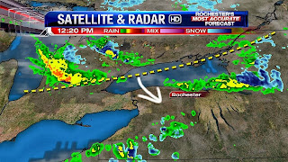
Limited Lake Effect on the Way...
Written by John DiPasquale:
Yes, a little taste of winter, or November has been with us & will continue to be right through the start of next week. Details are below...
Much of today will end up being dry for most, but as the afternoon progresses the band of lake rain over the big lake will be slowly dropping south thanks to a trough pushing in & eventually through late today & early tonight. As the trough passes so to will the band of lake rain, which will likely mix with ice pellets(graupel) & a little snow at times, especially away from Lake Ontario later this afternoon & evening. Temperatures will be in the mid to upper 40s prior to the precipitation, but once it moves in the air will cool into the upper 30s to around 40! The gusty west-northwest wind will also make it feel more like the 30s to around 40 for the rest of this Thursday.
Tonight will feature a scattering of lake rain, snow & graupel showers that will tend to taper down late. A few lake rain & snow showers will likely be around Friday, but a lot of the day should be dry with even a little sun from time to time. It will be brisk with highs in the mid to upper 40s.
The weekend will feature a fast moving clipper that will generate a lot of wind Saturday & some mainly rain showers during the afternoon that may mix with a little graupel & snow. Highs should get well up into the 40s to around 50, but the wind chills will be mainly in the 30s.
Sunday looks to be the better of the two weekend days, but it will still be chilly & brisk with a few rain & snow showers off the lake. Highs should be in the mid to upper 40s with a little less wind & possibly a few rays of sun sneaking out from time to time. Fingers crossed for that. Somewhat of a warm up should occur after a chilly start to next week, before a real soaker MAY occur on Halloween. Lots of time between now & then for this to change, so stay tuned through the next several days for updates on your Halloween & trick or treat forecast.
Have a great day bloggers!


Very November-ish out there today with the chilly wind and rain building in. Next week's storm potential still looks quite interesting, and it looks like the chill moves back in for a time behind the storm.
ReplyDelete