
A Little More Snow on Tap...
Written by John DiPasquale:
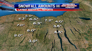
The latest snowfall totals are above & clearly show the least snow fell across the Finger Lakes region where we had some mixing & even plain rain in the Central, Southern & Eastern Finger Lakes late last night, as expected. The eastern half of Wayne County also received about 2 to 4" of concrete snow. The jackpot was in Wyoming County over the higher terrain where about 8 to 9" fell, while much of Monroe County, including Rochester picked up around a half a foot give or take an inch. Another 1 to 3 or 4" should add up from late today through tonight compliments of lake snow for many areas around & north of Routes 5 & 20. Also be careful if you will be traveling late today & tonight, as untreated surfaces will ice up with temperatures dropping into the 20s, plus there will be some blowing & drifting of the fluffier lake snow. So when all is said & done, I believe about 5 to 10", with a few spots upwards of a foot, will be on the ground for most waking up on T-day morning. Thanksgiving itself will feature a little lake snow shower activity to start, but by enlarge it should be a dry, brisk & cold with highs in the mid 20s!
A little, weak clipper will deliver a little general light snow Thursday night into Friday morning with maybe a coating to an inch or so from it, but that's it. Friday afternoon through most, if not all, the weekend looks good with slowly moderating temperatures to boot. Highs Saturday should make the low to mid 30s & mid to upper 30s Sunday, but it will be brisk.
Have a great day & Thanksgiving bloggers!
Weather will be back to quiet for next 7-10 days. See nothing on the models. Enjoy Thanksgiving!
ReplyDeleteNext arctic outbreak and potential NE snowstorm…Dec. 9. Waaaayy off though.
ReplyDeleteNot sure why you say it will be quiet. Lake effect snow tonight and Thursday and Thursday night. Potential East coast storm mid-next week per the EURO.
ReplyDeleteSnowdog with all due respect not sure where you are seeing any model show a potential east coast threat next week? I think you are miss reading the EURO.
ReplyDeleteYes. Sorry. My bad. It does look quite for awhile.
ReplyDeleteArctic outbreak late next week, which likely means another round of LE at least.
ReplyDeleteNothing showing for the next 10-14 days. Pretty quiet for a while. Hope we do not pay for getting an early storm this year. You get your hopes up for a few storms and you get just that one.
ReplyDeleteI just want temps that will cut back on the snow cover.
ReplyDeleteSomeone last week said to watch out for the first week in December and that it could be active. Not gonna happen. Very quiet for awhile now. Boring!!!!!
ReplyDeleteLots of little impulses on tap, but nothing of significance until we get to December 10th or so. And yeah, I specifically remember someone saying that the midweek storm would miss wide right for sure and that the real fun would happen during the first week of December. Well the first part of that thought has already busted and the second part looks to do the same. At least it's not nearly as boring as last year though, and at least we aren't sitting here waiting for the first inch. Plus from what I've read the balance of the upcoming month has a high probability of being colder than normal, so we have that going for us too.
ReplyDeleteI think it was the same person that said the last storm would not be a big deal and saying it would move East because of climatology. That person was wrong then and was wrong about the first week in December. That is ok. None of us are perfect. This is a blog to discuss what we think will happen. Looks like we will get near 50 by Thursday and then cool down, but no storms in sight.
ReplyDeleteThe models are showing a west, possibly WSW, wind after the next arctic front moves through. That's good for lake effect off the east end of the lake, and south of Rochester, but not here.
ReplyDeleteJust pay attention to the next 2 weeks for a major storm to pop up. Btw do not think that I was wrong on the last "Storm". I had 4-8 with for more likely for most. I believe 6 was the general average for most. Much closer to my 4-8 than the 10-15 or 6-10 forecast by our expert? It is just my unprofessional opinions. People do not always have to comment that I am wrong when especially in fact I was more right than wrong.
ReplyDeleteNo one likes a backtracker. You said at first that it would be a sure miss and now you're backtracking, just accept it, learn what you can from it and move on. We're all gonna make it brah.
DeleteIt's going to become really active after this Thursday/Friday...
ReplyDeleteWell let's hope "active" doesn't end up being "lots of cold rain."
ReplyDeleteWhat do you mean by "really active" Weatherguy?
ReplyDeleteIt looks to get active storm wise, but where will these storms go? To our West and warm us up and then cold with LE after the front passes. Will they go to far South and East and miss us completely or will they be a direct hit? These are the BIG questions we always ask. We will have to wait and see what happens. It will be interesting to watch.
ReplyDeleteSee post December 1 at 9:30 Anon. Thanks
ReplyDeleteAny updates Weatherguy based on latest data?
ReplyDeleteLooks as though the jet is going to stall in a favorable position to give us storm potential. Way too early but I would start paying attention to the Saturday-Tuesday time frame... I'm sure News 8 will mention it in a couple days time.
ReplyDeleteCould get interesting next weekend and early next week. I think Weatherguy may be on to something. Waiting to hear what News 8 thinks.
ReplyDeleteWhat do you guys see? What models are you looking at? Thanks
ReplyDeleteBIG snow in the Upper Midwest- 18-24 inches they are calling for. I am jealous. We just have not seen that type of snowstorm in a long time.
ReplyDeleteI am not sure the position of the northern jet is favorable for us. Looks like that arctic high is going to right over us. That will shove any storm off the mid-Atlantic coast (I believe they are looking at snow & ice in TN, VA, MD next week) and stifle any lake effect. On the flip side of that, the eastern front of that cold high is not far away from us, so if a Low sneaks past it on the eastern fridge, it will give us a snowstorm. Perhaps I am full of crap too.
ReplyDeleteThe NWS offices around NY state are starting to talk about a potential significant storm Sunday night into Monday. Where will it track is the BIG question??? There also looks to be a few waves moving along the stalled cold front midweek through Friday with snow and ice. Not sure if that will affect us or be South of us. It is getting interesting again.
ReplyDeleteI agree with Chris and see nothing that shows a snowstorm for us the next 10 days. Not sure what people are seeing on models other than hoping a storm is coming.
ReplyDeleteThe models did not look good overnight for snow in any areas along the east coast. The trends are going towards rain, rain, and more rain.
ReplyDeleteDid you look at the GFS model????
ReplyDeleteYes did you? Did you look at the GFS that just came out? Not good.
ReplyDeleteThat will flip flop back and forth as the GFS always does. I think it will redevelop along the coast locking in the cold air. Probably a snow to a mix back to snow.
ReplyDeleteYes you may be correct wondering what the News 8 team thinks about Sunday/Monday time frame?
ReplyDeleteYes, I would be great to get an fresh opinion from one of them seeing how we are blogging on a November 27th post....
ReplyDeleteIce might be a concern for Sunday night Monday time frame. Cold high pressure to our northeast might keep a cold northeast flow across the area with a storm passing just west or over head, could lead to an ice problem. The current 850mb-1000mb thickness shows favorable conditions for freezing rain. Very early!! The NAO is forecasted to go very negative middle of Dec. this might bring down some VERY COLD AIR. It does look like an active period coming up. We will see.
ReplyDeleteI just bought some new tires, I'm hoping to be able to test them on the snow soon!
ReplyDeleteHamlin Power you are mentioning something that is a real possibility at the current time. We all know how nervous we get about an ice storm. Really interested in what the News 8 team thinks. I know the weather people yesterday on all of the channels really mentioned nothing about this weekend and a possible storm.
ReplyDeleteI am sorry I see us on more of the rain side than anything else.
ReplyDeleteI would NOT be surprised either if it where a rain event. The latest EURO has it mostly, if not all rain for the same event. It also holds the cold air north throughout the forecast period. The GFS has the possibly icy event and the cold air rushing in throughout the forecast period. Way to early to know, I was just tossing the idea out there for thought. Both models showing MUCH different solution. I would tend to favor the EURO on the storm track, and the GFS on next weeks cold rush. Either way there is lots to watch in the weather early this winter.
ReplyDeleteIt is not looking good for snow that is for sure. Snow to mix to rain and then a little bit of snow on the back end. The snow we now will be gone by Friday and not sure when we will get it back. Maybe some LEs next week for some.
ReplyDeleteIt looks like we are back on that all too familiar pattern with storms moving West of us and we are on the warm side. It looks like the winds will align out of the west next week so most will not even see lake effect.
ReplyDeleteWay early to figure out exact track. Be patient you never know.
ReplyDeleteExactly. Look what happened last week. Most thought the storm was going out to see and we ended up with a nice white thanksgiving.
ReplyDeleteMaybe I'm alone in this but looking at the models for this one has been making my brain hurt. It's way too early to tell what is going to happen to Rochester with this storm as far as I can tell.
ReplyDeleteI think for next week's storm we'll be looking at a decent front end thump of snow before a changeover to mixed precip, then rain, then back to light snow. Too much cold air at the onset to not see at least a short period of wintry precip, how long it lasts depends on where the primary surface low tracks/how quickly any secondary coastal redevelopment occurs. Jo-Sef is right, models are all over the place with this one. Given the depth of the trough out west though I think it's wise to hedge away from all snow at this point. If this ends up being the type of pattern that takes storms to our west then I'm pretty confident it won't last beyond the middle of next week.
ReplyDeleteRochester's Most Accurate did not seem to concerned about any storms the next week or so. Think we see nothing to worry about.
ReplyDeleteThat very same Rochester's Most Accurate also predicted that last week's storm would move out to sea, even as recently as four days before it happened. Never trust a forecast beyond Day 4, not even from the best of the best.
ReplyDeleteNothing happening even the alarmist at the other station said no storms to worry about last night.
ReplyDeleteLatest AFD mentions the possibility of light snow accums on Friday, 1-4 inches with the highest amounts in the southern tier. It doesn't look like they've updated the long term section, but I can tell you that the model trend on next week's storm is east. On the GFS it looks like a solid 3-6 inch thump before a changeover to a light mix, with the low center tracking over the eastern end of Lake Erie. So no major storms for the near term, but definitely not clear sailing either.
ReplyDeleteI love how we now get blog updates every 2 weeks at best from News 8. That shows you how quiet the weather has been the last 2 weeks.
ReplyDeleteOkay you must be trollin' son. We just had the snowiest late November period since 2002, measurable snow 7 days in a row, got down to the single digits at one point and even before all of that we had some combination of rain/wind every 5 days at least. That is literally the opposite of quiet. Maybe you're just being sarcastic and I'm not catching it, I dunno...
Delete