
SIGNIFICANT SNOW FALL STILL EXPECTED
TUESDAY 4 P.M. UPDATE
Written By: Scott Hetsko
Snow has begun to fall across Western New York this afternoon. Travel will become difficult this evening and overnight as snow becomes heavy at times. Snow will mix with sleet and rain just East of Rochester overnight. The crucial hours of changeover will be from about 1am to 6am Wednesday morning which will knock snow tallies down in the Finger Lakes. The latest data has been trending colder aloft for Rochester which lends more confidence in our area getting up to a foot of snow. Below see the totals through 6am Wednesday.
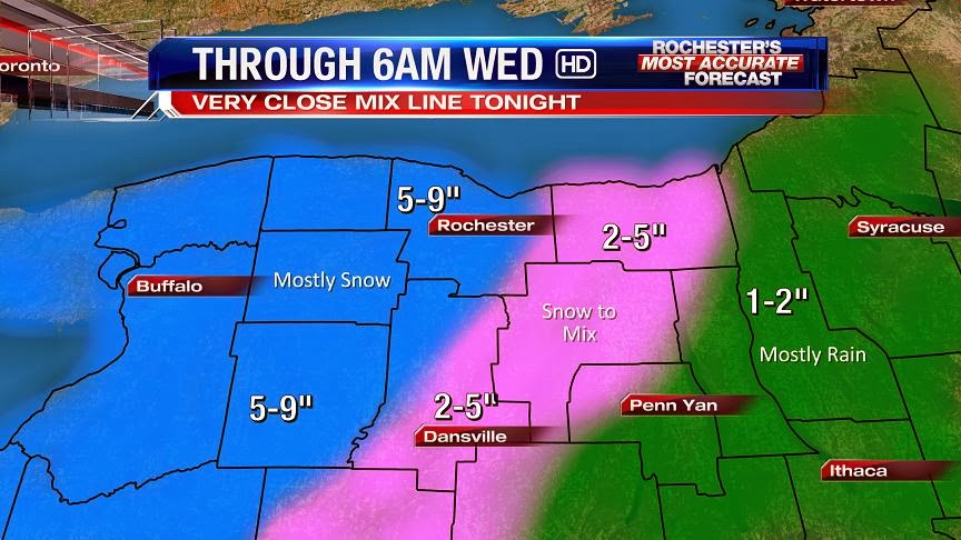
Lighter snow will fall in the morning hours on Wednesday. As the storm track Northeast, it's forecast to deepen to about 976 mb by Wednesday evening. Some additional snow will fall Wednesday evening into Thanksgiving morning off of Lake Ontario. I think another 2-4" are possible at that time. Much colder air and strong winds will blow and drift the snow around. I'd give it a 10-20% chance that some in Monroe county may see up to 14" but I'm not including it in my official forecast. Enjoy the Winter Storm!

Sounds good!
ReplyDeleteThanks Scott! Always appreciate hearing how you lean, and the caveats to your official forecast.
ReplyDeleteBtw. You can still click my name if anyone wants to throw their prediction in the ring.
https://docs.google.com/forms/d/1u6c4BH8oGIztrGC3LhctFX2yEiEV5RPZacwF510sMQY/viewform
Radar starting to darken up over western NY
ReplyDeleteThis storm is wimpy and again 6 inches total for most areas will be on the high side.
ReplyDeleteYou said 4 inches would be the max earlier.. if we get 8 inches, are you going to claim victory?
DeleteYawn anon 702,unsigned predictions are worthless.
DeleteWhere did everyone go?
ReplyDeleteGood packing snow out there right now. Few more inches and then I'm going to build a fort so I can throw snowballs at my neighbor in the morning. Snow rocks my socks.
ReplyDeleteAnybody seeing accumulations yet? I'm in Hilton, and it's not quite covering the grass, but almost. (It's been snowing lightly for a long time, but it is so wet it is only just starting to stick). If it keeps up at this rate, I'm predicting 2-3 inches by morning at best. I'd be happy with a couple more on top of that so the kids can go out and play!
ReplyDelete4.5 inches in Caledonia at 1:30 am.. this storm is going exactly as forecast. .
ReplyDeleteThat was a storm!? Wimpy.....
ReplyDeleteWe got about 4-5 inches in Hamlin. Just enough to work a 16 hour shift, now its bedtime.
ReplyDelete6 inches was my prediction (see 7:02 post) and that would be on the high side. Again on top of my game and a far cry from the 10-15 predicted or the 6-12 predicted. Nothing major and that is good for the holiday.
ReplyDelete7 inches in Western Wayne county. It was a disappointing storm once again. For once I would like to see us on the high end when a forecast is given.
ReplyDeleteIf we do get another 2-4 by tomorrow morning we will reach the 10" mark here in Western Wayne county.
ReplyDeleteBoarding my flight in time at airport. 6 inches (I'm guessing?). No problem. I love Rochester. I was afraid we might not get out.
ReplyDeleteBoo! 3 inches in Hilton. Sorry, I know you didn't want to hear the word "bust" Scott, but it was here for sure! Are we still looking at a couple inches today? The radar doesn't look promising.
ReplyDeleteHave to say the intial forecast of 10-16" was busted before storm started and Scott acknowledged his over zealous forecast early on and dialed it back in early yesterday. With that said, his map posted at 4pm yesterday for accumulation through 6 am Wednesday was DEAD NUTZ!
ReplyDeleteSolid 6" in Chili. Sure it was on lower end, but it's still in the 6-12" range predicted. Also, still have some lower level moisture that the lake may have fun with once the cold air starts invading our area. Lastly, lets remember people that last November we would get excited to see one single snowflake. Getting a decent size storm this early in the year is a victory in my book. Rather than get worked up about the totals, just enjoy the snow!
ReplyDeleteCompare the 4pm overnight map to these numbers guys, their final forecast nailed it.
ReplyDelete000
NOUS41 KBUF 271249
PNSBUF
NYZ001>008-010>014-019>021-085-280049-
PUBLIC INFORMATION STATEMENT
SPOTTER REPORTS
NATIONAL WEATHER SERVICE BUFFALO NY
749 AM EST WED NOV 27 2013
**********************24 HOUR SNOWFALL**********************
LOCATION 24 HOUR TIME/DATE COMMENTS
SNOWFALL OF
/INCHES/ MEASUREMENT
NEW YORK
...ALLEGANY COUNTY...
RUSHFORD 7.1 630 AM 11/27 CO-OP OBSERVER
1 E WHITESVILLE 1.5 727 AM 11/27 CO-OP OBSERVER
...CATTARAUGUS COUNTY...
PERRYSBURG 9.0 631 AM 11/27 CO-OP OBSERVER
1 SSW FRANKLINVILLE 7.0 700 AM 11/27 CO-OP OBSERVER
...CAYUGA COUNTY...
8 SSE AUBURN 2.6 600 AM 11/27 COCORAHS
...CHAUTAUQUA COUNTY...
3 SSE FREWSBURG 7.5 645 AM 11/27 COCORAHS
JAMESTOWN 7.4 602 AM 11/27 SOCIAL MEDIA
4 ENE JAMESTOWN 6.8 700 AM 11/27 CO-OP OBSERVER
4 SSW RIPLEY 5.1 600 AM 11/27 COCORAHS
...ERIE COUNTY...
EAST AURORA 6.0 504 AM 11/27 COCORAHS
1 N ORCHARD PARK 6.0 700 AM 11/27 COCORAHS
ALDEN 5.5 635 AM 11/27 NWS EMPLOYEE
WEST FALLS 5.5 624 AM 11/27 SOCIAL MEDIA
2 S AKRON 5.0 520 AM 11/27 COCORAHS
3 WSW ELMA 4.7 600 AM 11/27 COCORAHS
BUFFALO 4.5 658 AM 11/27 NWS OFFICE
4 N BUFFALO 4.1 659 AM 11/27 COCORAHS
ESE KENMORE 4.0 535 AM 11/27 COCORAHS
ORCHARD PARK 4.0 330 AM 11/27 BROADCAST MEDIA
1 ESE EAST AURORA 4.0 600 AM 11/27 COCORAHS
3 S CHEEKTOWAGA 3.5 645 AM 11/27 SOCIAL MEDIA
1 NW KENMORE 3.5 600 AM 11/27 COCORAHS
...JEFFERSON COUNTY...
CLAYTON 6.0 400 AM 11/27 SOCIAL MEDIA
WATERTOWN 5.5 623 AM 11/27 SOCIAL MEDIA
3 NW ADAMS CENTER 3.8 709 AM 11/27 TRAINED SPOTTER
NATURAL BRIDGE 2.1 558 AM 11/27 TRAINED SPOTTER
...LEWIS COUNTY...
6 N CROGHAN 2.0 700 AM 11/27 COCORAHS
LOWVILLE 2.0 730 AM 11/27 SOCIAL MEDIA
1 NW CONSTABLEVILLE 2.0 500 AM 11/27 COCORAHS
1 SSW GLENFIELD 1.5 600 AM 11/27 COCORAHS
HIGHMARKET 1.0 313 AM 11/27 CO-OP OBSERVER
CONSTABLEVILLE 1.0 313 AM 11/27 CO-OP OBSERVER
5 SSW HARRISVILLE 1.0 530 AM 11/27 COCORAHS
...MONROE COUNTY...
GREECE 6.5 658 AM 11/27 TRAINED SPOTTER
ROCHESTER INTL ARPT 6.3 658 AM 11/27 ASOS
HENRIETTA 6.0 700 AM 11/27 SOCIAL MEDIA
ROCHESTER 5.0 646 AM 11/27 SOCIAL MEDIA
CHILI CENTER 4.0 639 AM 11/27 SOCIAL MEDIA
...NIAGARA COUNTY...
NORTH TONAWANDA 5.2 713 AM 11/27 CO-OP OBSERVER
6 E NIAGARA FALLS 4.7 700 AM 11/27 CO-OP OBSERVER
NIAGARA FALLS AIRPOR 4.7 700 AM 11/27 CO-OP OBSERVER
...ONTARIO COUNTY...
PHELPS 4.5 646 AM 11/27 SOCIAL MEDIA
...ORLEANS COUNTY...
MEDINA 4.3 647 AM 11/27 SOCIAL MEDIA
1 N MEDINA 4.2 600 AM 11/27 COCORAHS
...OSWEGO COUNTY...
W FULTON 3.3 530 AM 11/27 COCORAHS
MEXICO 3.0 623 AM 11/27 SOCIAL MEDIA
4 SSE LACONA 1.8 700 AM 11/27 COCORAHS
...WAYNE COUNTY...
1 E NEWARK 3.6 700 AM 11/27 CO-OP OBSERVER
NEWARK 3.6 622 AM 11/27 SOCIAL MEDIA
...WYOMING COUNTY...
WARSAW 9.0 639 AM 11/27 TRAINED SPOTTER
6 SW WARSAW 8.0 630 AM 11/27 CO-OP OBSERVER
ARCADE 6.8 646 AM 11/27 SOCIAL MEDIA
And Scott was right about power issues. We lost power for a couple hours this morning. If we got a foot, we wouldn't be blogging right now...
ReplyDeleteAbout 4 inches of heavy, wet snow in Lyons. About 6 flakes to the pound!
ReplyDeleteI had just over 7" of heavy snow pile up in NE Fairport near the Wayne county line. I bet if I had measured more frequently to negate packing, it would be over 8".
ReplyDeleteI think they nailed the forecast once Scott reduced the initial predictions released Monday afternoon. Seems like the cold air didn't come in as soon as originally thought and the storm moved quicker.
Too bad the cold air didn't move in sooner or maybe it really would have piled up.
The good thing is that for travelers this should not be as bad as it could have been.
It looks like a winter wonderland with the snow clinging to everything. Time to go play.
Andy
We got about 6" in Penfield, just east of NYS Rts. 250 & 286. Looks like we may be in the 90th percentile for snowfall in the area. Too much warm air around kept the snow totals down. Whenever there are two lows, it is a difficult forecast.
ReplyDelete