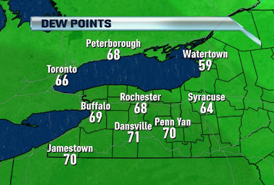
Hottest Day of the Year
Written by John DiPasquale:
Wow! Check out the dew points & temperatures as of 10AM this morning. Talk about heating up fast with lots of humidity! The steamy air mass is moving in as I type & if you head out at all from here on out you will feel it. A front that has been hanging out over the area for the last few days will finally clear the area & pull north as a warm front. This will result in lots of heat & humidity, & so much heat that we could actually break a record high for today in Rochester. The current record for this last day of May is 91 set back in 1944. We'll see. Right now it looks like it could very well fall. Today will likely be the hottest day of the year, as we surpass the 86 degree reading we had on Sunday pretty easily, I believe.

There is a slight risk for a pop-up storm late today, but for the most part we will be dry through today.
A strong cold front will blow through early Wednesday with some clouds & possibly a few widely scattered showers & storms late tonight &/or early Wednesday. Behind the front, it will turn windy, cooler & much more comfy with less humidity! Good riddance, if you ask me! Temperatues with increasing sun tomorrow will fall out of the 80s & into the 70s during the afternoon. It should feel great with the cooler, gusty west winds.
A reinforcing shot of cooler air will push through late tomorrow night into early Thursday with a few clouds, but that should do it. In the wake of second cold front late Wednesday night the temperatures will struggle to make it out of the 60s!! Temperatures should rebound back into the low to mid 70s with sun fading behind more clouds later in the day.
A warm front will likely cross the area late Friday night/Saturday morning with a couple showers & storms & following it we should climb back into the low 80s for the weekend & into the start of next week. It should feel pretty good! Finally, we are getting a chance to dry out & warm up overall! Boy, do we need it. Enjoy & stay cool today everyone!

No comments:
Post a Comment