STORM ARRIVES LATER, LOOKS LESS IMPRESSIVE


Written by: Bob Metcalfe
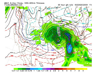
Above are the outputs for 0z Friday (Thursday @ 8pm) from the most recent runs of the GFS (left) and Euro (right).
What screams at me is that the two are now coming closer to an agreement on the location and strength of this storm down the road. Thursday is now a non-issue. Onset looks like it'll even hold off until late Friday morning at the earliest.
What this latest model run does suggest however is an increased possibility of a little snow to fall before it turns over to rain. The model is now resolving the large wave patterns a bit better and realizing that it was being over-abundant with warm air advection ahead of the storm. Still leaving heavily towards the rain side for most of Christmas at this point however.
This storm has just entered the Pacific northwest coastal area. It still has to traverse the Rockies over the next day and a half. So the cat isn't out of the bag yet. A lot can happen, and in the past crazy things have happened with regards to lee cyclogenesis east of the Rockies. I know there are several of you reading this still crossing your fingers... don't give up hope completely yet.
Per say this storm does turn out to take a trek east, at least it will time out AFTER most of the Christmas travel is done, which isn't necessarily a bad thing. In theory, a white Christmas is great, but white means worse in regards to driving and flying. Maybe we can get the best of both worlds? You can't blame me for being optimistic!
No comments:
Post a Comment