Chilly & Damp to Begin the New Month
Written by John DiPasquale:
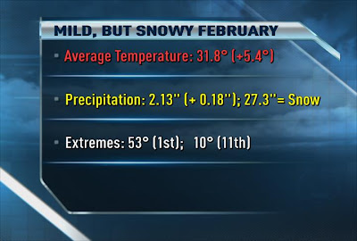
Well, big surprise...February was another very mild month! The 4th straight month with the average temperature being 5 to 5.5 degrees above average! However, at the Rochester Airport just over 27" of snow fell, which is almost 6" above average for the month. So while it was a mild month, it was a bit snowier than average, at least at the airport where the records are kept.
A little rain today mixed with wet snow at times, mainly over the hills south of the thruway will slowly taper off tonight as temperatures ease back through the 30s.
Friday will become breezy & milder with a little sun & highs getting well into the 40s. Come Friday night into Saturday some very strong winds will likely develop, which has caused the National Weather Service in Buffalo to issue a High Wind Watch for Friday night through Saturday for the POTENTIAL of wind gusts to reach 60 mph! It's not yet a warning, so this is not a certainty, but is a distinct possibility. Stay tuned. Those strong winds expected to develop Friday night will likely bring about higher temperatures, 50s later Friday night into the start of Saturday! There also should be some showers & maybe even a t-storm or two during the aforementioned period. In the wake of a cold front Saturday, though, temperatures will tumble back through the 40s & into the 30s by day's end Saturday.
Late Saturday night into Sunday the combination of the cold air deepening & a trough swinging into the area will likely cause some snow showers & a few squalls to develop. This activity should last right into the start of Monday, with some at least minor accumulations possible. Temperatures will likely be in the mid 20s to low 30s for highs Sunday & Monday with wind chills in the teens & maybe even a bit lower than that at times! Brrr...!! However, starting Tuesday a pretty big warm up seems to be in the making, especially by Wednesday. We'll see if it comes to fruition, but right now it looks pretty good. Could be a pretty long stretch of unseasonably warm weather right into the middle of March, but then again long range forecasting, especially this time of year gets a little dicey, but the way this year has gone it would not surprise me at all. Stay tuned.
Have a great day & night everyone!

Everyone complains about no snow we did have an above average month it just all melted fast. Its nice to think of think of the possibility of a warm spring and summer tho.
ReplyDeleteWe did not get much snow at all here in the southerntier, no where near what Rochester got for the season. Putting the disappointment behind me, thinking back a couple seasons ago, anyone remember the beginning of April when we had our first 80+ degree day for the spring season? Oh it was so nice, maybe this year could be the same?? Only time will tell.
ReplyDeleteThe above average snowfall at the airport is very questionable. 2 of the channels Mets even stated so. They reported 15" with that lake effect even a few weeks ago when evryone else reported about 8". I think they measure differently.
ReplyDelete