
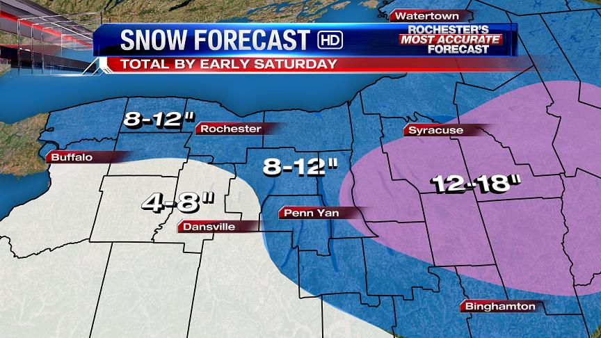
8-12" OF SNOW EXPECTED BY EARLY SATURDAY
NEWS 8 WEATHER TEAM SNOW FORECAST
FORECAST MODEL PREDICTION FOR SNOW AMOUNTS BY TOWN

Written By: Scott Hetsko
A Nor'Easter will deliver our second area wide snow storm of the season in the Rochester region. We expect TOTAL to range between 8-12" by the time the storm winds down before sunrise on Saturday. The steadiest snow will fall after 9 a.m. and continue through Friday night. Travel is expected to become more difficult as the day wears on due to steady snow and snow covered roadways.
The brunt of this storm will strike Eastern New York and New England where 1-3 feet of snow will accumulate by Saturday afternoon. So be prepared for a slow go on the roads in Western New York on Friday.
Thanks Scott, I really do like you and respect your accuracy when it comes to forecasting. The only thing is that I really believe your forecast amounts are on the high end for us. I most likely will be wrong but I really believe here in Western NY, by the time this is all said and done, the highest totals will be between 4-6 inches. I just think that the northern storm is going to be dominated by the southern storm faster than predicted, resulting in less snow for us and huge amounts east, once that low bombs over the east coast. Tomorrow afternoon will be a tricky commute, but nothing we are not used too. I just think we are going to have more of a mix than anticipated. Just my thoughts. You are most likely right with your amounts, but I enjoy looking at all kinds of weather data, and coming up with my own forecast. :)
ReplyDeleteSo here is the list of forecasts so far:
ReplyDeleteChannel 8: 8-12
Channel 10: 8-12, 12+ near the lake
Channel 13: 6-12, 12+ near the lake
NWS: 8-12
TWC: 9-15
AccuWeather local: 6-10
AccuWeather main site: 6-12
Margusity has us getting 3-6 inches on his snow map but that whole thing is underdone IMO. Other than that it seems like a pretty good consensus of forecasts to me.
What time do you expect the snowfall to start in the morning
ReplyDeleteWe can only do our best! Time will tell I guess.
ReplyDeleteYou do your best! You guys are the only ones I watch when it comes to weather.
ReplyDeleteJust for fun. Enter your Storm Total predictions here
ReplyDeletehttps://docs.google.com/forms/d/1xtwokVGUZrWHjYbf5VRRckm5UT38w4hzctXb2XA-KL0/viewform
Current Predictions
https://docs.google.com/spreadsheet/pub?key=0AhsaXd1CqdLydFdLcmVyd0xJUmRkb1VLandBUWtGb3c&output=html
You are using the airport measurement or are you doing your own?
DeleteI'm not measuring anything. I'm just throwing out a spreadsheet for fun. But the aiport measurement sounds most reasonable arbiter to me.
Deletemy submission didnt work
DeleteIt's there. There is a 5 minute delay (It's a google thing) before the spreadsheet is updated. Thanks for playing.
DeleteAfter 8am it should really start picking up and especially in the afternoon it will be heavy! I think of 8 inches north of the thruway. I think Rochester as a shot at a foot with this storm. I will not be surprised at all if someone north of the thruway gets 12-16 inches of snow. I know you guys will yell at me and say that wont happen but its not out of the question, at least I don't think so. traveling will be bad in the afternoon tomorrow especially when schools get out and 5 when every one gets out of work.
ReplyDeleteRemember, if you enter a number in the spreadsheet make sure it's for the airport, not your house.
ReplyDeleteFinally some snow for the whole area, NOT JUST HERE IN HAMLIN. In the last few weeks we have had more snow than we have had in many years. VERY SNOWY, with no end in sight!!!!! It is snowing lightly right now BRING IT ON the more the better 12+ in Hamlin.
ReplyDeleteThis storm will not verify with those numbers just mark it down. This is not a strom for our area. Seen this before and the transfer will happen quickly and be to far east for big snow. 3-5 inches at best for Western,NY
ReplyDeleteAt least the first comment was a lot more humble than yours. This isn't even a transfer situation it's a phasing situation. Even so we aren't going to see a markdown of 5-7 inches unless the northern energy gets sucked completely into the southern energy about 6-8 hours faster than forecasted. Which isn't likely when we're only 18 hours out.
DeleteLOSER
ReplyDeletehttp://wxcaster.com/gis-snow-overlays.php3?STATIONID=BUF
ReplyDeleteThe NAM is now outputing 15-20 inches of snow over rochester and north of the thruway areas between Buffalo and Syracuse. I wonder if we will see an uptick in forecasts overnight.
The NAM has a known wet bias. Throw it in the garbage.
DeleteMy data shows NAM with about 9" for Rochester area. Don't know what you're looking at...
ReplyDeleteBy the way, MODELS don't make our forecast. I've spent more time today looking at case studies of what actual storms have delivered in similar situations.
ReplyDeleteSo Scott based on your case studies are you confident that the city of Rochester will get about 10-12 inches? Also do you think there is concern for schools tomorrow in regards to afternoon dismissal?
ReplyDeleteYes and yes. I honestly would not issue a forecast that I didn't feel good about. It doesn't guarantee it WILL happen :)
ReplyDeleteThanks Scott for the feedback.
ReplyDeleteCrazy no one has been on here
ReplyDeleteWhere is everyone? This storm is no longer?
ReplyDeleteIm here, snowing now in Hilton
ReplyDeleteSnowing in Greece.
ReplyDeleteFireworks start tomorrow!
ReplyDeleteWhat do you think we will get with this storm David?
ReplyDeleteHere is a shocker, Scott has lowered his totals. Yesterday he said 4-8, today he said 8-12 and now he is back to 4-8. What the heck. Up and down, up and down and now down. This is hilarious.
ReplyDeleteWarm front snow tonight, not the storm yet. Snow won't really fall in a steady fashion until mid to late morning. Steadiest snow looks to be in the late afternoon and evening hours.
ReplyDeleteHey Macedon, listen carefully pal. Didn't change a thing.
ReplyDelete4-8" has been the forecast South which is what I meant when I said "4-8 inches for some"
ReplyDeleteScott, it was not anythng against you. I was referring to how the storms changes all the time. Sorry if it sounded that I meant your storm forecats changes.
ReplyDeleteBoy I wish I could spell. Keep up the great work Scott.
DeleteThanks, Macedon. I appreciate that, it's never easy to forecast snow let me tell you.
DeleteI hear you buddy. You do a great job as always. I do not envy you guys when it comes to forecasting snow totals. I love your comment about Jim Cantore. That made me laugh. It is true though. If Jim is in your city, watch out, the big storm is a coming. Have a great night Scott.
ReplyDeleteThe Cantore comment was pretty funny.
DeleteWhen will Jim ever come to the Flower city?
ReplyDeleteLet me just be the first to say this. This will be a bust for our area with 2-4 tops. Also Boston maybe a foot at best. This is way blown out pof proportion for epicness. Not that big of a deal. Just on record now before it comes tomorrow you will wake up and hear numbers dropped drastically.
ReplyDeleteYou will be wrong on all counts, I guarantee it.
Deletei can totally see this be a bust. if we get it. it wont be until late tomorow nite w/ LES enhancement. the western system is way too far north. we will prob see mix until like 5pm on friday. as for yu scott, yu were right not to hype this thing up. if we get 8 in roc i'll be amazed. rochesterdave
DeleteIt was a busy day for me, I'm still here just haven't had time to say much. I wish I was in charge of making the snow-day calls, I'd do it now so I could stay up and have a beer. Regardless, I'm looking forward to tomorrow afternoon. Goodnight all.
ReplyDeleteMacedon take your pills buddy. You are about as annoying as a ingrown hair on your @$%^&&##. Seriously though, you are high maintenance.
ReplyDeleteStay off this blog if you have nothing good to say. Thanks
DeleteWell we will find out what happens tomorrow! everyone seems to not think it will a 8-12 event but we will see. most of the experts have us in the 8-12 inch range. for some reason the weather channel has us in the 12-18 inch range. think that's way more than what we will get though, at least my opinion. 10-15 max! with most nearing a foot north of the thruway.
ReplyDeleteBoth systems look mighty impressive on radar. That northern energy is like a super clipper on steroids.
ReplyDeleteYou would think by watching the Weather channel that the only places getting snow are NYC and Boston. Why do they focus so much on thes 2 cities and leave the rest of the area out of the picture?
ReplyDeleteThere now saying Boston could see 2-3ft or more from this storm. Wow!!! Very very jealous.
ReplyDeleteIt makes our 6-10 look like a dusting.
ReplyDeleteBecause nyc and boston are major cities and a storm of that magnitude cripples anyone and shuts everything down. We could have a foot here and everyone will still stop at wegmans on the way home tonight ir go to the mall.
ReplyDeleteExactly! 2ft of snow would hamper us for 12-24 hours after the snow stopped, for major cities like Bos and Nyc it could be a couple days, and impacts far more people.
DeleteClosing schools for 3-6 inches of snow. How embarrasing!!!!!
ReplyDeleteHave you seen radar and whats coming.... Talk to me in about 5 hours
DeleteNot to mention there are hardly any closings. We will be getting more than 6 inches and the worst conditions will be during the afternoon/evening when schools are letting out. In my opinion the people who make those calls never seem to know what they are doing, I'm pretty sure all they do is look out their window. Gotta go to work now, should be fun driving around today.
DeleteI think Scott is right on with his amounts. 4-8 inches by Saturday morning.
ReplyDeleteNorth and West, closer to the lake, will see 8-12
DeleteScott is not calling for 4-8 inches he is calling for 8-12 inches
ReplyDeleteDamn. I wish I had gotten my snowblower fixed...
ReplyDeleteSnowing steady in Hilton...
ReplyDeletesome of the fattest snow flakes ive ever seen...
ReplyDeleteTHE BAND COMING AT US LOOKS VERY NARROW AND LOOKS TO BE MICING SLEET IN BUFFALO. IT DOES NOT LOOK VER IMPRESSIVE.
ReplyDeleteVery Light snow started in NE Fairport around 930am and has gradually intensified. Still light at 950am.
ReplyDeleteAndy
The downgrade from winter storm warning to advisory south of Rochester does NOT mean less moisture it just means that they will get more of a mix in precip. They never were forecasted true winter storm warning criteria anyways.
ReplyDeleteGood morning. Here in West Henrietta we had nothing, then about 9:05 we had fat flakes. Now at 10:16 we have rain, just rain as far as I can tell.
ReplyDeleteSteady snow in Hilton since 9am. About an inch on ground...
ReplyDeleteDavid there is some yellow on the radar is that coming right at the city and I presume that is heavy snow?
ReplyDeleteThats sleet and some rain. Warm air is shooting up lake erie. Once the winds turn north, it will be all snow....
DeleteCouple drops of rain in Caledonia earlier.. nothing falling at all at the moment.
ReplyDeleteI think that's rain that's yellow on the radar...
ReplyDeleteRain that stinks if it is rain but all mets said the heavier snow will be after noon until tonight. It looks like it is moving very slowly?
ReplyDeleteBust. They are starting to drop the WInter Storm Warnings already West of us.
ReplyDeleteThere is going to be a sharp drop in snow amounts as you head South.. the 4-8 area on the news 8 snow map might be in trouble.. the rest still looks reasonable to me.
DeleteWest Henrietta. Rain, rain, rain.
ReplyDeleteWinton Place (Pinnacle Rd) Heavy snow.
All snow in the city so far. I say we are still on track for the News 8 forecast. The next time the spreadsheet guy sets something like that up we should come up with some kind of perk for the winner.
ReplyDeleteLove to get an update from the News 8 team on what they think now. We are reading rain and bust what is happening?
ReplyDeleteCaptain Josh on channel 10 just tweeted that he is still confident of 8-12 for #ROC...
ReplyDeleteHard to get 8-12 when it is pouring rain out...
As I mentioned early yesterday. We will see more of a mix than all snow. I still believe after 3 or 4pm, we will get a period of heavier snow that might make the afternoon commute a bit tricky, but I really do not see anywhere near 8-12 inches for a storm total. Once this clipper gets absorbed into that low off the east coast, the snow will quickly diminish for us. Any snow falling right now is melting on the roads because of the warmer temps.
ReplyDeleteSorry, but I still might be wrong. :)
Depends on where you are.
DeleteIt's Nemoing in Greece. I would have expected it to be more orange than white....
ReplyDeleteSnowing pretty good in Fairport no rain?
ReplyDeleteSolid 2 inches in Hilton and coming down at 3/4 to 1" per hour
ReplyDeleteStill rain (not freezing rain) in Henrietta.
ReplyDeleteit is Snowing in Fairport. It started at about 9:30 with light snow. Right now there is a moderate snow fall with fat snowflakes!
ReplyDeleteSolid snowfall from NE Fairport to Pittsford.
ReplyDeleteAndy
Nothing in West Henrietta except for drizzle.
ReplyDeleteStill raining with a little itty-bitty bit of snow mixed in -- Henrietta South. Temp seems to have dropped slightly.
ReplyDeleteI am starting to think that this storm is becoming a bust for us.
ReplyDeleteFor who?
DeleteSouth of the Thruway.
DeleteSteady Moderate to heavy snow in Brockport right now. Near 3" Total so far.
ReplyDeleteSteady Moderate to heavy snow in Brockport right now. Near 3" Total so far.
ReplyDeleteNot sure you can say bust if what all mets said yesterday comes true. They all said the heavy period would be between 3 and 9 pm. City getting some moderate snow for the last 2 hours.
ReplyDeleteWith as little snow as we have had this winter I would be happy with a sold 8". I'm looking forward to palying in the snow with my kids when I get home to Brockport.
ReplyDeleteRay
Rain rain go away... my kids want to play...
ReplyDeleteStill raining in Henrietta.
Anyone from News 8 out there with an update?
ReplyDeleteYes, please, an update. We are experiencing quite a bit of rain in Henrietta. Is this going to change, and when? Fascinating weather today.
ReplyDeleteRaining around the Eastview Mall area.
ReplyDeletedoing nothing in farmington right now...what a joke.
ReplyDeleteModerate rain in Caledonia..have yet to see a flake.
ReplyDeleteNothing here in Newark, Wayne County....Where the heck is the SNOW!
ReplyDeleteIt's in Greece Gilbert. I'll send some your way :)
Deletethey try to show on radar that most is in the form of snow but the radar must be wrong because everyone is reporting rain and a mix. i would venture a guess that totals will be dropped here locally because of that. oh well. we are used to it. i'll enjoy what we get.
ReplyDeleteWest Henrietta. Now starting to see a bit of snow mixing with the rain, but still very wet heavy "ploppy" snow. Raindrops very evident in puddles, so it is now "snaining" out.
ReplyDeleteIt's been coming down pretty good here in Greece (Latta/Mt.Read area)for awhile. My lab sure loves this weather!!
ReplyDeleteIt's been snowing steady all morning here in Greece. Have about 3" of super heavy, dense snow now. On the midday newscast, John stuck with their original forecast map. I believe it for where I'm located, I mean if we haven't even seen the heaviest of it yet. But I do feel for you all further south; with all the talk of rain this morning...
ReplyDeleteWell I wasn't expecting much this far south anyway.. I just hate cold drizzle..lol
DeleteAdam, where in Greece are you? My post is right above yours. It's starting to pile up pretty good now!
DeleteDewey/Stone Area... just got back from starting to shovel, and the first spot I did already has at least another 1/2 - 3/4" on it!
DeleteWest Henrietta. 12:43. Rain is now snow. Big flakes.
ReplyDeleteSnowing hard in the Holley / Kendall area in Orleans county. A solid 5" so far and coming down hard right now.
ReplyDelete-Matt
Zippo in Avon. Note my surprise.
ReplyDeleteComing down pretty good now in West Henrietta. This could be the big one!
ReplyDeleteIf you call kind of coating the ground some but not the pavement the "big one."
DeleteIt's going to suck driving home this afternoon from work. I hope they have 390 plowed.
ReplyDeleteWithout the snow 390 sucks to drive in.
DeleteIt's remarkable how quickly the pine trees have started really drooping with the weight of this snow. I feel really bad for the snow lovers on the blog who are getting rain. Hopefully it will start piling up for you guys too!! We don't want to be snow hogs!!
ReplyDeleteHow is 390 now?
ReplyDeleteFine in Henrietta. South is wet.
DeleteIt sucks to be you guys...up at highland park it's been snowing all day - huge wet flakes. There's about 3 inches so far on the ground but this is some really dense stuff. It's actually pretty remarkable how heavy the snow has been falling with so little depth on the ground. The rest of my work day has been cancelled.
ReplyDeleteSame here in Henrietta. It has been snowing pretty hard, but because of the moisture content of the snow it is barely coating the ground.
DeleteSolid moderate plus snowfall on my ride from Pittsford plaza to NE Fairport. Continues to pick up.
ReplyDeleteAndy
Be nice since we do have a storm to get an update from someone on the News 8 team thought that is what the blog did.
ReplyDeleteHi All! Sorry I haven't gotten on here sooner, but have been rather busy updating website, graphics & looking at new information. For those of you that are raining &/or mixing in Southern Monroe & points south, you will most likely see your cold rain & mix go to all snow in the next hour or so, while areas east of Rochester north of the Thruway will see increasing snow intensity over the next couple hours. Near & south of the Thruway from near Farmington across the Finger Lakes will get into the snow & mix with a pretty quick changeover to all snow expected by the mid to late afternoon, as colder begins to overspread area with weak low transferring it's energy to rapidly intensifying nor'easter. Heaviest snow for most will occur between about 2 & 8 this evening, & a little later for the Central Finger Lakes region. The ride home late this afternoon into the early evening will be rough to say the least for all. Snow will slowly lighten later this evening & transition to lake enhancement & lake effect later tonight into the start of Saturday. The snow will also become fluffier tonight into the start of Saturday due to the colder air blowing in on gusty north winds. The sun will return come Saturday afternoon, while New England will likely be topping off the historic snow totals out there, upwards of 2 or 3 feet in portions of Southern New England!! Enjoy snow lovers & be careful if you have to head this afternoon or tonight!
ReplyDeleteJohn