
Groundhog Day Storm
Written by: Stacey Pensgen
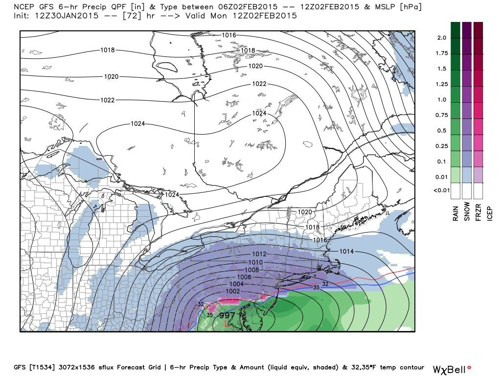
Just a quick update with the 12z runs of some of the models. Matt will have another update this weekend. The EURO isn't in yet, but the 12z GFS and NAM both are, and both have been trending slightly more north. TRENDING. SLIGHTLY. Does this mean anything? Yes, I think so. The closer we get, the more the models hone in on a solution. Canadian was the winner a few days ago, but the 0z trended south, while the other guys brought the snow further north. 12z isn't in completely yet, as of this writing. So, here is what we're looking at:
GFS:


I won't be happy with any amount below 6 inches :P
ReplyDeleteThat's what she said.
Deletehttps://i.imgur.com/meftV0qh.jpg
DeleteGo live in the Southern Finger Lakes then if you want significant snow or even Boston. Stop complaining that if it is nothing below 6" it is a bust. How was your drive in this morning -- other had a more difficult time.
DeleteO___o
DeleteI was just joking calm down. That's what the :P was for...
Save a Canadian, ride a Brit:
ReplyDeletehttp://img.meteocentre.com/models/ukmet_amer_12/P1_GZ_D5_PN_072_0000.gif
Might be worth noting that it's had this solution for the past three runs. Fingers crossed that its short range brilliance continues.
Bernie Rayno the one guy I think is good at accuweather says he believes this storm will go more north for what that is worth. Not sure what is leading Stacey to be pretty matter of fact that the Rochester metro will get light snow?
ReplyDeleteDef not matter of fact at this point. Storm would have to jog north about 100 miles for us to be in the sweet spot with big snow, but I think even a 25 mile shift north could mean the difference between 1-3/2-4" in roc vs. 4-8/5-10". Those numbers aren't specific, just an example and I'm far from confident on this yet.
DeleteStacey
25 mile shift isn't that much. Enough to keep me on the edge of my seat. One of these will surprise on the high side, I suspect. Maybe this one.
DeleteFrom KW:
ReplyDeleteNAM/UKMET bullish on sig snow ROC Sun pm/Monday. GFS/Canadian say we are living on the edge. Will EURO gives us a firm direction? Hmmm.
Southern Tier looks to be in play for 6+ inches right now. I expect watches will go up tomorrow for southern tier with advisories in the Roc/Metro area.
ReplyDeleteCanadian is back on track with a little more snow than the GFS actually. Haven't been this excited for the Euro in quite sometime...
ReplyDeleteWeatherguy where to you go for the Canadian Models.
ReplyDeleteYou can either go to tropicaltidbits and it's the CMC model under "global models" or just google "Canadian GEM"
ReplyDeleteKeep in mind that Tropical Tidbits uses 10:1 ratios for their snow maps. The algorithm Levi Cowan (site owner) was using previously was consuming a lot of computing power, so he had to simplify things.
ReplyDeleteFrom ALB NWS:
ReplyDeleteTHE QPF FIELDS AND 2D-FGEN FIELDS LINE UP
MAINLY SOUTH OF I90 ON MONDAY WHERE AN ACCUMULATING SNOW EVENT IS
EXPECTED. ENSEMBLE DATA AND PLUMES NOW SUGGEST MORE THAN HALF THE
MEMBERS ARE FURTHER NORTH THAN PREVIOUS RUNS. IN FACT...THE LATEST
30/06Z NAM12 IS FURTHER NORTH AS WELL WITH MODERATE QPF VALUES. WE
WILL REINTRODUCE THIS POTENTIAL MILLER TYPE B EVENT INTO THE HWO
AT THIS TIME. THERMAL PROFILES ACROSS THE REGION ARE NOT ONLY COLD
BUT WILL OFFER A CHALLENGE WITH RESPECT TO LIQUID TO SNOW RATIOS.
THE HIGHER RATIOS WILL LIKELY BE ALONG AND NORTH OF I90 WHERE
VALUES COULD BE APPROACHING 20:1.
Stop cutting and pasting from other sites, and use your own words. You imply to be such an expert. So if you are, interpret what you are reading vs posting from another site; which anyone can so.
DeleteI don't think your criticism Is necessary as I don't interpret his post as that he is acting like it is his words. I don't mind it actually. It saves me the hassle of having to go read the discussion myself.
DeleteDon't knock the guy for cutting and pasting. All relevant forecaster input is welcome IMO.
DeleteI agree with Farmington. I apprrciate the cut and paste. I don't have time to check a bunch of sites. The All Caps of the bulletun male it obvious what is not original thoughts
DeleteI for one am not bothered by NWS clippings on a weather blog.
People do it constantly on every weather forum I visit and no one is ever against it. So why not here too? This place kind of functions as a de facto forum anyway.
DeleteRatios will depend heavily on lift and moisture. Weak lift and/or low moisture in the dendritic growth zone = deflated ratios.
ReplyDeleteI always thought low temps = high ratios ?
ReplyDeleteEuro12z still south for us just a few inches .Not good but have to see what tonight's models show but need a 100 mile shift north.
ReplyDeleteSorry guys, but this just looks like another miss for us. I think we will be on the Northern edge of this thing while areas South in PA will ge a good snowstorm. Just has not been in the cards for us this year.
ReplyDeleteStill in play Snowdog have to look at the runs tonight because then I believe everything will be fully sampled. If we get a north movement of about 75 miles on the Euro we are in the foot range. You never know.
ReplyDeleteReally who wants to be stuck inside on Sunday during the Super Bowl during a Winter Snow Storm. Hoping for some light snow, and then head to the nearest sports bar for some beer, wings, and a good game on TV.
ReplyDeleteFROM KW:
ReplyDeleteLatest NAM is such a sweet track for ROC snow...but gotta think it is bit too far north, with the sweet snow spot being NY So. Tier into PA.
FROM THE NWS:
ReplyDelete3 TO 5 INCHES
OF SNOW APPEARS POSSIBLE ACROSS THE SOUTHERN TIER...WITH AMOUNTS
THEN LOWERING TO 2 TO 4 INCHES ACROSS MUCH OF THE NIAGARA FRONTIER
AND FINGER LAKES REGIONS...AND THEN TO AROUND AN INCH OR SO ALONG
THE LAKE ONTARIO SHORE AND OSWEGO COUNTY. AFTER THAT...AN ADDITIONAL
INCH OR TWO MAY THEN FALL MONDAY MORNING BEFORE THE SYSTEM PULLS
AWAY.
NOT LOOKING GOOD FOR ROCHESTER.
Miss again to the south and east. This winter is just so frustrating.
ReplyDeleteNot sure why everyone thinks we are out of this right now.The 18z GFS looked very similar to the last NAM run which gives us good snow. I know it is the NAM and 18z GFS but at least we are breathing. If the Oz GFS and Euro are on board here we go. If not then I would say it is done.
ReplyDeleteThey're jumping on the very conservative NWS discussion, which is severely downplaying this thing IMHO. CWAs off to our west have already issued winter storm watches, as did KTAN for southeastern New England. Trigger needs to be pulled for the southern tier counties I think.
DeleteThe GFS just got NAM'd. Noticeable north shift on the 18z run, totals are 12+ regionwide. Now what's all this about a guaranteed miss south?
ReplyDeleteCCCC please see my post 5:01 please.
DeleteI did see it. What's your point?
DeleteYou said all this talk about it south but more importantly you know it is the NAM and 18z GFS. Tonight's run and tomorrow more important.
DeleteAbsolutely. But as long as even the most worthless of guidance has something in the works for us then a miss isn't guaranteed. Yet people are once again writing it off completely. Not like we get completely shafted on the southernmost guidance either...other than a few rogue ensemble members everything gives us at least a few inches.
DeleteFolks, RELAX. There is still time for this thing to shift further north, or go too far south. They are forecasting base on what they see. I'd be willing to bet that the next couple of shifts at the NWS will have to tweet their forecast for our benefit or not to be determined. And before anyone starts to ride the "bust" train, no one on here was ever predicting. Sure thing jackpot for us, not the pros or the posters. Look at last night and today. I didn't here jack about it snowing most of the daylight hours in Farmington, but it did. Was it big? No. The point is that it was snowier Than I expected and there is enough for me to fire up the snow blower. So it's just adding up. If we get less than 6 inches Monday big whoop. Hop in the "glass is half full" train with us, I guarantee you will live a happier winter with a more positive outlook. My $.02
ReplyDeleteAbove should say "tweek" not tweet.
ReplyDeleteFor what it's worth, GJ stated that even though right now he thinks the heaviest will be south the way it looks now, he still thought 6" or more by Monday morning because of lake enhancement which is the wild card we need to start looking into. KW also say we've on edge. Light accumulation as it looks now but the slightest shift north is a game changer. Let's hope for a shift north! Then I was thinking to myself, the southern zones get the screw job whenever we hVe no synoptic moisture. So they deserve some decent snow so people can get out and ride their snowmobiles etc. maybe it an come a little north and spread the wealth to all of us.
ReplyDeleteI just want to point out how amazing it is that we've gone through so many possible outcomes for this thing in just a few days, and with so little lead time. We've run the gamut from big storm to cutter to sheared mess to DC special...now this. And we're STILL wringing our hands over what the final outcome will be. I think the best part is that there's pretty much zero difference between the current crop of solutions and what we had before the waffling began, so we've basically gone in a giant circle since a few days ago. I want to get off Mr. Model's Wild ride.
ReplyDeleteI posted in earlier and will say it again Bernie Rayno who is at accuweather and I believe is the best one there said this storm is coming north. So again tonight and tomorrows runs will give us our answers. By 1:30 tomorrow many will be excited on the blog or the complaint department will open back up.
ReplyDeleteHe sounds bullish about it really impacting us right now: http://www.accuweather.com/en/weather-video/snowstorm-to-impact-chicago-p/4023710323001
DeleteBut, like he said, it seems to keep trending northward!
JN seems a tad excited right now. Talking about "overperformer potential" and a "watcher" and "may be significant." I like to think of him as a sort of KW-Lite.
ReplyDeleteI also want to say how "impressed" I am with how the upgraded GFS has handled this storm so far. I put "impressed" in quotes because no model has been anything close to impressive, but in regards to trends the GFS has led the way this entire time. When it crapped a big storm the GGEM followed, when it lost the storm entirely everything else followed, when it brought the storm back to a DC special everything else followed, and when it began shifting the thing north everything else followed once again. And it hasn't been an outlier at any point, which would've happened to the old version at least a few times by now. So it won the day with the big nor'easter, and now hopefully it can bring us on home and win the day with this storm as well.
ReplyDeleteAlthough I did forget about the UKMET, which has represented the northern edge of the guidance envelope for the past few days and never really followed any trend. I hope it can pull the coup.
DeleteNow we all just have to wait patiently for about 5 more hours before the 0z GFS drops...
ReplyDeleteWe're all about patience here.
DeleteLike kids are all about patience on Christmas morning.
It's just nice to hav something to track isn't it? Big or bust we have some meat on the bone still.
ReplyDeleteThe top two CIPS analogs are kind of porn-worthy. Number one is still V-Day 2007. The second one is March 6th, 1999. I'm trying as hard as I can to resist the temptation to go all in on those, because they were both more prolific than even the absolute best case scenario for this storm. I think they add some legitimacy to the north trend though.
ReplyDeleteI don't understand how looking at older storms can predict if this one will be good for us? Please elaborate.
ReplyDeleteIt's an analog. Seeing what happened under similar atmospheric conditions may be able to help predict what will happen in the future. They are also used for pattern evolution and some try to use them for seasonal forecasting.
DeleteThis is what makes this blog fun, the "potential" of getting a good sized snow. If it doesn't happen, it doesn't happen. But I appreciate all the weather enthusiasts, that are not bashing anyone, or saying NBD, or bust...........but just appreciating what may be and chatting about it. That is what this blog is all about! Keeping fingers crossed! LOL!
DeleteThe 21z SREF has a mean QPF near 0.6 inches, a substantial increase from the previous run. Ratios probably average between 15:1 and 20:1 using the COBB method, which translates to an 8-12 inch snowfall verbatim. It's worth noting that the majority of members are clustered above the mean, and only three are below 0.4 inches. Removing all outlier-ish members shifts the mean to around 0.65 inches, which would yield a 10-13 inch snowfall. But again, this is based off of just the SREF mean, not any actual forecast.
ReplyDeleteThe 00z NAM looks like it's coming in similar to 18z, maybe a bit wetter. A decent sign that the general northerly solution of the 18z GFS will hold for 00z IMO. The RGEM was similarly far north in its 18z run, at least as far as precipitation goes.
Is that a botched NAM run? Is something is up? It is almost exactly the same run. Has to be a red flag here. Could it possibly be that close to previous run???
ReplyDeleteThe last 3 NAM runs have been pretty close to the same. We get good snow out of it. But Oz GFS big and Euro.
ReplyDeleteOz GFS looks good for Rochester if reading it right 10-12 inches by Monday afternoon. Now hoping the Euro goes north too.
ReplyDeleteThis blog is surprisingly quiet.
ReplyDeleteWell Oz Euro was north too so as I see it if the models verify tomorrow we should be looking at an 8-10 inch snowfall but that does not take in ratios and possible lake enhancement. I will let CCCC and the others weigh in on what they see.
ReplyDeleteThe weirdest thing I have ever seen They have winter storm watches out for 2 counties. Livingston and Ontario. What the hell is that.
ReplyDeleteDisregard. I am an idiot. LOL
DeleteThe NWS says 2-4 for counties bordering lake Ontario us and 8-10 for Southern Tier. They do not seem to think a big deal for us.
ReplyDeleteTo me the track is even further North now. Almost into central Pa which is a great track for us. Is the NWS on drugs. Plus lake enhancement. would put us over warning criteria.
ReplyDeleteIn fairness they go on to say
Delete"If
later model runs continue to shift the track of this storm north
higher snow totals by be added to the forecast for Buffalo and
Rochester which may require a watch or warning with later updates."
I'm digging this northward trend. Hopefully Monday morning everyone digs it.
That is the thing. The models have trended North and we are fully in the game as far as I can see. With lake enhancement we will be over warning criteria. We could end up with more snow than South of us. They always forget lake enhancement.
DeleteThe models seem to be putting out over 8" I think.
ReplyDeleteI know everyone is focused on the potential, dare I say likely snow storm. But have you see Jan climate summary?
ReplyDeleteWith 1 day to go
Jan 2015 4.8 degrees below normal
Jan 2014 4.1 degrees below normal
We had 6 mornings below 0 in 2014 to 2 in 2015.
But average low is about 10 in 2015 to 12 in 2014.
This Jan is even more consistently cold than last year.
Raise your hand if you thought that would happen.
Ok I like what I'm hearing. Farmington is in Ontario county, but on the northern tip. Ontario and Livingston are very long counties north to south so they have areas that are closet isotherm tier hence the storm watch. I hope by day's end the track ends up allowing the entire area to be included in said watch.
ReplyDeleteI remember there was the first storm last season that was slightly to far south. Lakeshore counties where only under advisories at first. Lake enhancement Boosted snow total that where close to 18 inches in spots at the storms end. I am getting excited about our chances at some significant snow in ALL of western ny.
ReplyDeleteIt does now appear that we are in play for more than the 1-3 they were talking about a few days ago. I am excited to see how this plays out throughout today and tomorrow. I cNt remember a synoptic storm where we're we're going to be so cold. Sunday night/ monday morning looks really cold to be having all that moisture. Should be interesting.
ReplyDeleteLast winter's new years storm was colder IIRC.
DeleteWhere is CCCC weird e has not posted since several important model runs.
ReplyDeleteThat NWS forecast makes it seem like they're cherrypicking the ensemble members that depict the lowest amount of QP. If you're going as low as 2-4 inches for the lake shore then you're looking at 0.15-0.3 inches of liquid precipitation, but the overwhelming majority of guidance depicts 0.4 or greater all the way up to the shore. And I don't know where they're getting those ratios from, because BUFKIT depicts ratios averaging between 15:1 and 20:1 using the COBB method.
ReplyDeleteSREF mean QPF increased once again, now up near 0.8 inches. The Euro still wants to play the fringe game, but it did tick north overnight and I suspect that it's playing catchup. My guess is that the NWS won't want to play ball right away, and will issue advisories for the northern counties. My other guess is that those will be upgraded to warnings at some point.
Probably being overly cautious after the latest NYC debacle. Wouldn't want to be forecasting 10 inches and get a fraction of that so soon after having to apologize just a few days ago. Just a guess.
DeletePersonally I'm still rooting for Team UKMET:
ReplyDeletehttp://img.meteocentre.com/models/ukmet_amer_00/accum/PA_000-072_0000.gif
Just a modest 1-2 feet of snow right there if it verifies. Needless to say I don't think it will.
Latest NAM moved south that is not good. Means GFS and Euro will too. Think anyone north of the thruway gets a few inches.
ReplyDeleteA whopping 2 mile shift from 00z. Calm down.
DeleteCCCC, how important is the lake enhancement piece going to be? With the really cold air over the relatively warm lake will the wind direction support this during this event and if so when would it happen? I am still foggy about the time frame. Storm watch goes into effect at 7am tomorrow south. Is it coming in that soon?
ReplyDeleteI can see lake enhancement factoring in by early Monday morning. It becomes more important for good totals if the track ends up farther south, but then we're walking a thin line with very dry air sitting just to our north. Watches and warnings always begin hours before the expected onset of precipitation, so the southern tier will probably begin to see snow around late morning.
DeleteAnyone see this Forecaster in Arizona?
ReplyDeleteSeems like something Scott would say
Weather map goes crazy live on the air: http://youtu.be/iXuc7SAyk2s
Or click on my name
holy lol
DeleteWow 12z GFS is ramped up and still north. If reading it well likes nice for Rochester. Plus not sure but ratios could be higher than 10:1 plus maybe lake enhancement. This could be a good size storm.
ReplyDeletelol hivemind
Delete12z GFS holds mostly steady. Biggest change was a substantial boost in totals between Chicago and Detroit. No change in our region.
ReplyDeleteCCCC you seem pretty relaxed about potential? Should I read that as you think this storm will not be a good one or just being cautious? Do you think ratios could be 15:1?
ReplyDeleteAs much as I don't melt down when things don't look good, I also don't ballyhoo when they do look good. Ratios could definitely be 15:1, perhaps 20:1 at times.
DeleteWhat does that mean for Rochester? And how can you less than 30-minutes prior make the statement "No change in our region". Which is your educated observations are you finally going with or should we say, "posting from another weather website".
DeleteYou seem to have a problem with people posting things from other sites...
DeleteWinter Storm Watches already up. So why is everyone talking about probably won't see any watches, warnings, or advisories til Sunday. Also if everyone is reading the same systems -- why differing opinions. Also where are the local weather professionals. All seem to be potentially silent except for the ocassional "still waiting and watching". Some of us need to begin to prepare if this is going to be, as one on the blog are predicting, a sizeable winter storm -- hey maybe even a blizzard with winds and you add wind chills to that. Imagine Blizzard Warning, Wind Chill Warning at the same time. Unless you are truly need to work -- would look to stay home for the next couple of days at the beginning of the week.
ReplyDeleteWe aren't going to get a blizzard.
DeleteAnon 11:06 please we are not the experts. I would think the mets will be on this. KW tweets he has seen systems like this give Rochester a good amount of snow. He said high ratios and lake enhancement is likely. I am not sure where Scott has been on this. Think they are waiting to see what 12z Euro says in about 2 hours.
ReplyDeleteWe live in sothern Livingston Co. I would like to see a decent snow so I can take my girls out sledding! They have been wanting to get out and sled in the worst way. Everyone knows that the best time to sled is during a good winter storm! BRING IT ON!
ReplyDeleteChris
I think you might get your wish Chris. And for the anonymous worried about staying home from work or staying in for a few days; I don't think we are talking about anything crippling. No need to worry. It will probably be enough snow to make things difficult but we live in western ny and this is what we expect and are used to every winter.
ReplyDeleteWinter Storm Watch has been extended north to include Monroe County.
ReplyDeleteIt was only a matter of time. I think the NWS is still reluctant to post headlines ever since Cuomo made his egregious statement about the November LES. Also, as always in these scenarios, they will most likely downplay the Lake Enhancement, so I would expect most areas to be at the higher end of whatever range they decide to forecast.
ReplyDeleteScott seems to be not too impressed. Posted that heaviest snow is south of I90, plowable for most.
ReplyDeleteThat was not his most recent post either.
DeleteSure was, posted it 3 hours ago. The other posts were about watches.
DeleteI'm going to assume he will forecast 6-10" for most, with 8-14" for the Southern Tier. Unless he sees something that we don't...
ReplyDeleteWinter Storm Watch posted -- looking for Warning to come up. I'd like folks to define plowable.
ReplyDeleteI can envision somewhat higher totals near the lake too. And I promise I'm not just saying that because I live near the lake :P
ReplyDeleteUsed to live by the lake -- Lake Enhancement is no fun -- be prepared to get up early to shovel, and shovel, and then shovel some more to get your car out.
DeleteI agree, areas along and north of Rt 104 from Niagara to Wayne counties usually do just as well as areas south in these events. Sometimes the highest totals come out of towns like Hamlin. I can only hope.
DeleteCheck tweet from KW and JN; both are using words such as significant, heavy snows, system such as this notorious for heavy snow amounts to be expected. Morning drive on Monday to be difficult. Interesting how they are using such words and nothing from other local weather folks. Again, is it ratings they are looking to increase.
ReplyDeleteThose two are always more bullish than the other local forecasters when it comes to storms. I tend to notice that it works out more often than not. And neither of them are wrong on this one the way it looks right now.
DeleteSo are you saying they are correct this time about significant, heavy snows for Sunday through Monday? Again, someone was blasted earlier for talking about the potential for a significant Winter Storm, and now it sounds like you are agreeing. Are you?
DeleteI have a question. KW last night was saying how this storm will be a "fast mover." The watches that I am seeing go for a 24 hour period of time. A 24 hour storm, to me, isn't a fast mover. Not many are actually taking WHEN this should go through the region. From what you folks are seeing, do you see the main stuff being like a night time occurrence or well into Monday?
ReplyDeleteLate Sunday night through early Monday evening by the look of it. It's a fast moving system but it's also quite large in size.
DeleteCool, that makes sense. I like big snow as long as I don't have to travel. I can rearrange my schedule to not have to travel and then enjoy the white stuff! :)
DeleteSo you plan to stay home. When someone else on the blog mentioned this -- they were blasted by others for over reacting. Are encouraging people to do the same -- stay home due to the travel and conditions which will be expected? What are you seeing.
DeleteI'm saying I don't feel like dealing with it tomorrow whether it's 5 inches or 2 feet. I'm not going by travel advisories, I'm going by how I want a day to chill and enjoy the snow.
DeleteECMWF is onboard with the northerly track.
ReplyDeleteWhat's it look like out there Ollie?
ReplyDeleteMartin rd is drifted like normal, just like the old days with the bronco. :-)
DeleteGunna snow!
ReplyDeleteAnd there you have it.. it's gunna snow. Thanks Ollie. Stayed tuned to see Diane eat an entire blueberry pie with out using her hands..
ReplyDeleteTime for a full-tilt weenie post: there's a meteorologist on AmericanWx who is currently very bullish about the jackpot totals being much further north than current indications. Like basically centered right along the Thruway. I don't know if I'd go that far, but I've definitely noticed that the biggest numbers do usually occur north of the forecasts in these setups. The north trend began late Thursday night, has continued unabated ever since and currently shows no sign of stopping. 3/6/99 continues to be a top CIPS analog (although I'm absolutely certain we aren't getting nearly that much snow), and several of the other top analogs look pretty nice as well. And according to Bernie Rayno the storm shortwave is currently obtaining a negative tilt earlier than it was projected to do, indicating a slightly stronger and more northerly system, possibly a touch slower too.
ReplyDeletehttps://www.youtube.com/watch?v=krD4hdGvGHM
Ok.. I'm starting to get slightly excited. Not because it will be severe but just to watch a bunch of snow falling all at once. If Lucy pulls the ball out just before Charlie kicks it on this one I WILL LOSE IT!
DeleteSetting the over/under for Lucy ball pull at 6 inches.
DeleteOllie Williams is truly the world's greatest forecaster.
ReplyDeleteIt's interesting that the Valentine's Day Storm in '07 is also up there regarding the top analogs... As I recall, that storm gave the Roc airport around 18", but it also had a more SW to NE track.
ReplyDeleteI've been tempted to say that this setup smacks heavily of that one for the past few days, but I only went as far as to say it's a top analog because I didn't want to cause a freakout. 1/3/96 shows up on there too:
Deletehttp://www.eas.slu.edu/CIPS/ANALOG/IMAGES/COOP/72HR/1996/19960104_072_total.png
Cherrypicking to the max to be bringing up all of these heavy hitters though. Most of the analogs are way less robust.
What is the City doing to prepare for such heavy snow amounts over night. I remember the days leading up to last year's Blizzard messages were posted on 490 and 390 about travel and the approaching storm -- why nothing yet? Where are the City Officials? Maybe there are getting hipped for the Super Bowl
ReplyDeleteProbably the usual procedure. This still doesn't look like anything too special at the moment.
DeleteHow -- 7+ inches overnight on Sunday. If that is not significant, what is?
DeleteJust at Wegman's people starting to stock up on essentials. Some talking about 24-48 hours of significantly, heavy snows. Several feet.
ReplyDeleteDamn I wish. More like several inches.
DeleteRun out of hot dog buns?
DeleteOnly plebs need a bun for their weenie :P
DeleteSnow, wind chills, below 0 temperatures, blowing and drifting snow. I think that means a BLIZZARD in the Flower City in the next 48-72 hours. Mark it down!
ReplyDeleteVOODOO WEENIE WIZARD POWERS ENGAGED
DeleteAre you activating weenie mode for the Superbowl?
DeleteSuperbowl + storm. Full-tilt weenie mode. I hope Tom Brady gets twisted into a pretzel to make the whole thing perfect.
DeleteHow can 7 plus inches of snow overnight on Sunday, not be considered significant. Explain.
ReplyDeleteIt's definitely significant, but we usually see it at least a few times in a typical winter. Hence, nothing too special.
DeleteAs you guys have mentioned, models continue to trend further north and I wouldn't be surprised to see that trend continue on tonight's runs. Heaviest amounts look to fall south of I-90 but also along and north of 104. I'll have an updated blog post out this evening with our snowfall forecast.
ReplyDelete-Matt Jones
Sweet. Plus we won't have to scroll so far.
DeleteThanks for the update Matt!
DeleteMuch appreciated Matt.
DeleteThanks Matt
ReplyDeleteCan someone tell me a reasonable prediction on snow amounts from their amateur opinion? It will be interesting to see matts numbers tonight. I'm sure TWC is going 24 hrs straight so they can cover winter storm "Linus" and it's effects. Talk about hype.
ReplyDeletePreliminary opinion: 6-10 for most, with 8-14 south of US-20 and near the lake.
DeleteDo you think we are talking school closures? With the cold temps and decent snow + bad timing? Just trying to get a handle on what kind of impact we r talking.
ReplyDeleteSchool closures for sure. This is most likely going to have a BIG impact on ALL of WNY. The timing of the heaviest snow looks to be centered around Monday morning rush hour.
DeleteCCCC when I look at every current model it shows even north of the thruway at least 10 inches without I believe any lake enhancement? Also what we see on models is that not based on 10:1 ratios too? If yes I believe ratios will be higher. I am a rookie but tome this seems a little more significant than people are saying. Plus the Euro looked like the storm slowed down this last run.Idk but based on what I see on all the models this is a 12-15inch range by Monday evening. Where is Scott on vacation?
ReplyDeleteEvery snow map other than the ones from Weatherbell and Tropical Tidbit use calculated ratios.
DeleteThe new SREF came in with a mean QPF of 0.94 inches.
ReplyDeletehttp://thepatrioticbaker.com/wp-content/uploads/2011/07/red-hot-dogs.jpg
Come on CCCC put a number on it do not be afraid of the idiots on here. I say north of the thruway to the lake will be 12-14 and south will be at least 16 inches.
DeleteScott has mentioned before storms tracking through the Ohio valley produce BIG accumulations in WNY. The ECMWF also has a slightly stronger LP than its previous 12Z run, with a later transfer to the coast.
ReplyDeleteThis is sounding more and more like closed schools to me. Footish of snow. Centered on the AM commute. Single digit air temperatures.
ReplyDeleteA) What is everyone's over under on Storm Total.
B) Probability that most schools are open Monday?
No justification required. Just your gut feeling.
A) 9 inches at the airport
DeleteB) Less than 30 percent
Latest NAM looks very good for all of western NY. CCCC not sure why you believe in such a low number based on all the models moving continuously north. Do you think it is going to go more southerly? I just can not see at least a foot minimum.
ReplyDeleteCCCC can't win.
DeleteCalled, essentially, a snow monger one minute. Conservative a few hours later.
I still have hangups about the quick movement of the storm and how close the northern gradient is.
DeleteThis storm looks like it could have huge BUST potential with the slightest of shifts south. Precipitation graidiant on north side is VERY tight.
ReplyDeleteWhen is the next model of interest?
DeleteThat is not good to hear HP.
ReplyDeleteWe would need a south shift of around 30 or 40 miles to be taken out of the significant snow. That doesn't look terribly likely at the moment.
ReplyDeleteUgh great. Everything was in our favor too. This could end up being NBD afterall!
ReplyDeleteIt looks to me like the Southern Tier is in the jackpot zone no matter what happens. 12-18" for them, MUST BE NICE!
ReplyDeleteI live in the ST and we usually get shafted from the heavy snows, its nice to be in the sweet spot for once. I think schools will be closing tomorrow evening from what I am hearing.
DeleteModels now taking the storm back south?! Knew it was too good to be true! NBD folks!
ReplyDeleteAnyone know why News 8 has barely spoken a word of this storm? I mean we are in a storm watch and not a peep from them. Every other station is all over this except News 8. Why is Scott asleep at the wheel?!
ReplyDeleteWondering the same thing. KW has been all over this all week long, nothing from Scott at all. Even a snow map would be nice!
DeleteThey might be busy analyzing the situation. That's my guess.
DeleteThe above is an impostor. Not sure why not jist ask that question anon?
Delete- The Real Spreadsheet Guy
You think there would at least be something from them though! I mean we less than 48 hours out now. I am shocked to be honest.
DeleteAll of the above are imposters! (shaking my head)
DeleteI am shocked you keep taking my good name.
DeleteThough I hope news 8 starts a new thread soon, so I don't have to scroll so far to defend my honor.
We may have to throw down formulas to settle this.
DeleteWill the real Spreadsheet Guy please stand up? Haha this is comical at this point now
DeleteYou're all phonies...I'm the real Spreadsheet Guy!
Delete="We will get " & Randbetween (4, 16) & "inches" & Index({"Name Stealing";"Bust Screaming";"innappropriate gif posting";"A Memorable Storm"}, Randbetween (1,4))
DeletePeople stop with the name stealing please. And so what if Scott is asleep at the wheel, I'm sure we'll hear something soon rather than later. We have something to track, lets just be happy with that!
ReplyDelete- The Real Spreadsheet Guy
http://www.ssd.noaa.gov/goes/east/eaus/rb.jpg
ReplyDeletehttp://radar.weather.gov/Conus/index.php
She's a beaut ain't she?
Okay so 18z GFS has us again in the 12-14 inch range that is all of western NY. I do not get why people are not on board here with storm 24 hours out? Most models track this storm through SW PA. which I have always heard is a great track for Rochester including north of the thruway. Just confused that it would change that much when it is at our door step.
ReplyDeleteForm KW:
ReplyDeleteWe have told local snow clients to prepare for 8-12" of snow from late Sunday into Monday pm w/ blowing/drifting. Localized 12"+ tallies.
Why the NWS does not have all of us under winter storm warnings is mind boggling to me.
All of Syracuse in a WSW then how come all of Rochester is not?
ReplyDeleteBecause they are sleeping at the NWS in Buffalo.
ReplyDeleteI leave you all for a few hours and all hell breaks loose lol. Jk. I am looking forward to hearing how the local mets talk about this at their 6pm forecasts on tv. It is at our doorstep like bob said. The only thing I will throw out there is to be careful with models and their amounts. They may say 12-15 or something but Scott always says that in the end he uses climatology and now casting to get the final number. Just don't want anyone on here slitting their wrists if we don't get 12"! We will have to put Snowdog on 24 hour suicide watch. ( I'm only busting on you Snowdog. It is good to see you made it back on here)
ReplyDeleteMatt didn't pull the trigger on any specifics amounts on paper but did say most areas could get a foot, some more, some a little less. Other two stations were showing similar numbers so far.
ReplyDeleteMM on 13 had inches by 8:00am Monday morning and 12 inches by 5:00 in Rochester. In fact he had a higher total in areas by the lake because of enhancement. KW said 8-10 is high confidence with more in localized areas and he has seen this type of storm before. Not sure what 8 said because I missed it but not sure what Scott thinks because he has seen this before too I would think.
ReplyDeleteSorry that was 7 inches by 8:00am Monday.
ReplyDeleteJN seemed amazed that NWS in Buffalo does not have Monroe county in WSW. Amazing even though he was wrong maybe you see why Cuomo basically said they are incompetent. Sorry just see the Binghamton NWS more on top of things.
ReplyDeleteIt would be nice to hear from Scott but he is probably at home enjoying his family. He usually breaks it down And gives us his true gut feeling which comes from experience. Are we feeling this is going to perform as advertised, over perform, or disappoint some?
ReplyDelete