
Messy Weekend, COLD (& Some Snow) Next Week
Just typing up a quick new blog about the weekend/next week. Nothing earth-shattering with the latest runs. I think the warm air arrives too quickly for any good snow on the front end of the weekend system. Even if we do get a minor accumulation, mid 40s and a half inch of rain will get rid of that in a heartbeat. I am interested in Tuesday's clipper. I feel a lot of us underestimate those guys, because they are quick moving, but sometimes can surprise us and give us a decent 4-6" snowfall. I'm NOT saying that's what we'll get, but we've certainly seen it in the past. Winds move around a bit next week, so rather than 1 area (lakeshore, south of ROC) getting blasted with snow, I think there's a better chance of more of us seeing the white. That's good, right? Share the wealth at this point?? Wind chills will be the biggest story next week. Particularly Wednesday/Thursday. We'll update the blog again late weekend/early next week!
How cold will it get next week both air temps and wind chill values?
ReplyDeleteLows in the single digits late Wednesday/early Thursday, highs in the teens. Wind Chills likely in the 5-10° below zero range at least, likely lower.
ReplyDeleteStacey
So. Balmy compared to last year. Last year we dipped below 0 at the airport 10 or 12 times last year. I don't remember the number. I do remember throwing boiling water into the air at -9 last year. That was fun. But I'll settle for regular winter cold snaps like next week.
DeleteOh man that cold snap last January was fun for me...I was home for winter break and got to experience the lake effect blizzard. By far the greatest number of pure whiteouts I can recall in one storm. There were numerous instances where I couldn't see across the relatively small backyard. The wind chill really made it nasty though, I wouldn't have left my worst enemy out in that for longer than 20 minutes. Even after 5 minutes outside it would feel like hundreds of tiny razorblades were slicing across my face. And at one point there was snow accumulating on BOTH sides of the storm door. Definitely the wildest winter weather event of my life.
DeleteAnother High Wind Watch...lovely.
ReplyDeleteUnfortunately CCCC do not think the cold and snow next week will approach what you went through last January.
ReplyDeleteDefinitely not the cold or the whiteouts, but perhaps the snow amounts. I ended up with about 18 inches total from that storm. My current apartment is in the village of Webster, so I can envision myself getting within a few inches of that number over the course of several days.
DeleteLet's play "spot the main reason why we're going to freeze our nipples off next week."
ReplyDeletehttp://www.pa.op.dlr.de/arctic/ecmwf.php?im=8
Hint: the giant red blob is the polar vortex and the animation covers the past 14 days.
Because the red blob got kicked in the groin and got ripped apart? Amirite?
DeleteLol basically. The mean old stratosphere nailed it right in the jewels.
DeleteRead through the NWS and they mention nothing about Rochester getting any significant lake effect next week. They state the flow will be Westerly most of the time. They also state the clipper will only give us a couple inches so it it not that strong of a clipper. KW mentions HEFTY lake snow for Rochester next. I do not believe a word he says anymore as he has been more wrong than right this year. I think we will all come out with a few inches but nothing to write home about before we warm up by next week.
ReplyDeleteI meant warm up by the week after.
DeleteTime will tell Snowdog. I can say I am excited to see what next weeks weather will bring. I am looking forward to what I think could be a snowy week in WNY.
DeleteHow come KW mentions HEFTY snows, and when you listen to the other Weather people -- they are focusing on the cold weather, with possibly of snow for each day. Makes you wonder if again KW is trying to get folks to watch 10 for the ratings.
DeleteClippers are always a joke and you are lucky to 3 inches at most. Will it still get cold midweek?
ReplyDeleteYep..no real mention of snow next week by NWS....cccc thoughts???
ReplyDeleteI imagine the NWS is not mentioning snow very much next week since LES is not easy to forecast especially days away. I like others are excited at least the prospect of snow And the temps will definitely support snow. I choose to stay optimistic with HP. Sometimes we get surprised. I'm not saying I'm expecting snow but the chance is enough to discuss here. Can't be any worse than most of December was around here!
ReplyDeleteI would like to say regarding KW and his tweets. I honestly think they have nothing to do with the ratings at all. He loves the weather in particular the winter weather. His tweets are reflecting his excitement for POSSIBLE weather, NOT ratings. He is doing all of this on his vacation because of his passion for the weather. I would consider thanking him for that not bashing him.
ReplyDeleteCompletely agree! The guy owns his own snow making machine!!
DeleteI second that. Extreme cold isn't safe but it is also part of our winter weather. One of the reasons I like living in WNY: we get four seasons there is always something new to look forward to. My $.02
ReplyDeleteClippers can produce very high ratios, so they can surprise you with several inches rather than a few. This one has been consistently modeled with the potential to produce several inches. As for lake effect, the NW flow happens after the clipper moves through. The NWS does not state that the flow will be "westerly most of the time," Rochester should easily get involved and KW isn't the only one bringing it up. And the mid-month warmup is tentatively expected to be fleeting, in fact here is Brett Anderson's current thinking:
ReplyDelete"Signs still point to a warm-up from the Prairies to eastern Canada toward mid-month, then poss. another turn to cold late month."
By the way, that "forecasters do it for ratings" conspiracy theory has to be the dumbest, most counter-intuitive idea ever. If a forecaster is always hyping things that never come to fruition then that means they are always wrong, and if they are always wrong then people will take notice and stop watching their forecasts, thereby LOWERING the ratings for their station. Just simple logic. And as HP stated, KW is on vacation and doing this simply due to his passion for weather, although I think that passion bleeds into his forecasts way too often.
Feels cold outside right now are we sure nothing to worry about in regards to freezing rain?
ReplyDeleteWe're going to warm above freezing by later this afternoon once the SE flow strengthens. Just not a favorable setup for worrisome ice accretion.
DeleteFreezing rain advisory issued
ReplyDeleteSaw that already. It's for up to a tenth of an inch of ice and applies mostly to the higher elevations.
DeleteThe parking lots and my driveway are a skating rink in Greece! Be careful out there!!
ReplyDeleteThe low level cold layer is proving to be somewhat stubborn to move out. Still not expecting significant ice, just enough for some slipping and sliding until we warm above freezing.
ReplyDeleteSomewhat more pronounced signal today for improving teleconnections by mid month. If that trend holds then we can remove the "tentative" label from our fleeting warmup. There are vague signs of storminess after next week as well.
It's been 32 here in Farmington since lunch time so this ice is a little more than expected but they have been salting so roads are fine around us.
DeleteTemps are now above freezing and should continue to rise through the evening hours.
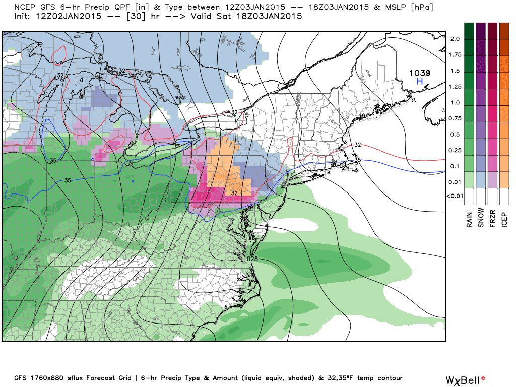
ReplyDeleteThe NWS is calling for 1-2 inches with that clipper Tuesday. So NBD. They are also stating that the lake effect could be confined to close to the Lakeshore North of 104.
ReplyDeleteThat's after much drier air moves in, so it's not a major detail. There's also this:
Delete"SNOW SHOWERS WILL GENERALLY BE CONFINED TO THE SNOW BELTS AHEAD OF THIS BOUNDARY...BUT NORTHWESTERLY WINDS BEHIND IT WILL LIKELY SPARK MORE WIDESPREAD SNOW SHOWERS SOUTH OF LAKE ONTARIO ON WEDNESDAY. ALTHOUGH MODEL QPF IS LIGHT...EXTREMELY COLD AIR MASSES CAN PRODUCE SNOW SQUALLS WITH BRIEFLY HEAVY SNOW AND GUSTY WINDS."
Keep in mind that the global models are very poor at resolving heavier lake squalls, so the "light" QPF is probably underdone for many areas. They can also have a rough time handling clipper snowfall amounts, so the actual end result could be anything from a dusting to several inches. Either way I'm not about to complain, this will be the first real wintry stretch of the season.
We are on the same page Snowdog! Minor clipper and as Scottie says zip code snow for very few. I even do not see the city getting below 7 degrees this week any day for a low temperature
ReplyDelete1) Find where anyone says "very few" will be getting snow, and post the link here.
Delete2) State your actual argument for the arctic outbreak not reaching the magnitude that every model and forecast currently indicates.
3) Why do you always show up right when Snowdog does? Are you two conjoined at the hip or do you both exist in a hivemind?
The NWS is indicating gusts up to 60 mph tomorrow, but I have doubts that we'll get anywhere close to that.
ReplyDeleteI just let my record speak for itself showing data here is a waste. Just let me record speak for itself as in this weekend .I was allover it as no snow coming and rain being the primary precipitation please check previous posts if you want data. Where is your evidence that we will not get a 60mph gust tomorrow oh it is a hypothesis based on data review?
ReplyDeleteSo you have no arguments or evidence, just a baseless assertion that you hope will verify. Got it. Also you were flip-flopping between "no snow" and "some snow" regarding today, pretty easy to be right when you cover enough bases. And I never said that we "will not" get a 60 mph gust tomorrow, I simply have doubts. And yes, those doubts are based around actual data such as the most recent mesoscale model runs.
Delete"I just let my record speak for itself..."
You have a record? Where is it? From what I see your "record" consists of one storm for which you made multiple predictions. You have no "record."
CCCC you do not know me. I may have many records just some I would not care to share on the blog.
Deletelol okay big guy
DeleteHa Ha CCCC in all seriousness when or how can it e fifured out if lake effect impacts areas south of the lake. Also when can reliable low temps be predicted for Wednesday/Thursday?
DeletePlus does it not look like that clipper going more south into Pa. not us?
DeleteOnce we reach Tuesday night then the lake effect picture should become more clear. Right now the clipper looks to deliver its highest accumulations south of us, but we wouldn't be left out if the current track consensus holds. Remember that northern stream systems can throw curveballs.
DeleteI will say that Wednesday night's forecasted low temperature may not be reached if we get enough cloud cover/moderating wind over the lake. There you go Bob, I made an argument for your assertion so now it looks a little better :P
ReplyDeleteThe low lying cold air was VERY stubborn along the lake in Hamlin tonight. The temperature didn't crack freezing until shortly after 8PM. The temperature has finally climbed to 36 in the past half of an hour. It was good for some OT :)
ReplyDeleteI just do not see much snow next week. Interesting fact. Last year at this time we had 46" of snow at this time. This year only 26" so far. I really think Scott went out on a limb predicting 110-130. I doubt we will hit 90" this year the way it is going. We will see.
ReplyDeleteEven nickel and dime adds up over time in a surprising way so we will have to see what happens starting this week. Stay positive. At least the cold part of the equation is happening this week.
DeleteTranslation of Snowdog's post: "I see everything through gray-tinted glasses so I completely missed these:
Deletehttp://www.tropicaltidbits.com/analysis/models/gfs/2015010406/gfs_asnow_neus_29.png
http://www.tropicaltidbits.com/analysis/models/gfsp/2015010406/gfsp_asnow_eus_29.png
http://www.tropicaltidbits.com/analysis/models/gem/2015010400/gem_asnow_eus_28.png
"
I know it's not what we want, but it's nice and mild out this morning! I will definitely get kids outside before te hammer drops this week. I'm not much of a model analyzer; anyone know if there is any updates on clipper, temps, and LES potential? Thanks.
ReplyDeleteAlso, when do high winds begin? It's pretty calm right now.
ReplyDeleteI can't see any high wind starting until after sunset. Upstream observations show nothing even remotely close to high wind, even all the way back through lower Michigan. The low still needs to strengthen more and it will, but the way I see it we won't reach our best window for strong gusts for many more hours.
ReplyDeleteNothing has really changed regarding the upcoming week, except the sweet spot for lake effect has been narrowed down to Oswego County. The whole stretch of shoreline counties should get involved at some point, probably during much of the day on Wednesday, but Oswego County will be the jackpot zone.
So CCCC are you saying that areas south of the lake Ontario are out of LES.
DeleteRead the first part of the last sentence.
DeleteThank-you what does the 12z GFS say as far as how much that clipper will give us?
DeleteA few inches.
Deletehttp://www.cpc.ncep.noaa.gov/products/precip/CWlink/pna/nao.sprd2.gif
ReplyDeletehttp://www.cpc.ncep.noaa.gov/products/precip/CWlink/daily_ao_index/ao.sprd2.gif
http://www.cpc.ncep.noaa.gov/products/precip/CWlink/pna/pna.sprd2.gif
Continuing signal for a more favorable synoptic arrangement just after mid month. We unfortunately lose our big beautiful EPO ridge by then, but the index only recovers to neutral so it wouldn't become an inhibiting factor.
KROC airport has already had gusts up to 52MPH at of 215PM!
ReplyDeleteSomebody please slap me the next time I try to speculate on a wind event -_-
ReplyDelete...although the Warnings were just downgraded to Advisories across the board, reflecting my concerns from yesterday. I feel better now :P
ReplyDeleteMost areas will get a few inches of snow in total for the week including Rochester. NBD for us. The clipper is weak and may give is an inch at most. The heavy lake effect will be confined to areas east of the lakes on a westerly wind. No BIG storms ahead. Snowfall deficit will increase.
ReplyDelete"Most areas will get a few inches of snow in total for the week including Rochester."
Deletehttp://www.tropicaltidbits.com/analysis/models/gfs/2015010418/gfs_asnow_eus_25.png
http://www.tropicaltidbits.com/analysis/models/gfsp/2015010418/gfsp_asnow_eus_25.png
http://www.tropicaltidbits.com/analysis/models/gem/2015010412/gem_asnow_eus_25.png
http://www.spc.noaa.gov/exper/sref/fplumes/index.php?YMD=20150104&RT=15&PRM=Total-SNO&SID=ROC&INC=ALL&NNC=&max=&min=&mZOOM=7&mLAT=42.3948150823389&mLON=-78.79436171875&mTYP=roadmap
http://www.wpc.ncep.noaa.gov/qpf/p120i.gif?1420413071
"The clipper is weak and may give is an inch at most."
http://forecast.weather.gov/product.php?site=BUF&issuedby=BUF&product=AFD&format=CI&version=1&glossary=1&highlight=off
"ON TUESDAY...MODEL GUIDANCE CONTINUES TO AGREE THAT A SHORTWAVE WILL BRING A SYNOPTIC SCALE LIGHT SNOWFALL TO ALL AREAS. BASED ON CONSENSUS QPF THIS SHOULD GENERALLY RUN IN THE 1 TO 2 INCH RANGE...BUT AREAS WITH LAKE ENHANCEMENT EAST OF THE LAKES SHOULD GET A BIT MORE THAN THAT."
Also there won't be any extended westerly flow at any point this week, it will be WNW before a turn to NW after the clipper. Your wrongness is honestly adorable anon-kun :3
Is that you Bob?
DeleteAll the models above show 4-6" for our area. That is a few inches in my book. The clipper is weak and will give us a whopping 1-2 inches at most. Areas East of the lake are going to get pummeled as the models you gave above show.
DeleteI was brought up that a few was 2, but to each his own. I'll take 4-6 and have the ground covered bring it on. LES won't pummel us here it usually never does. It may brush us a few times to bump up our totals and that's cool too.
DeleteAnd are you willing to Stand behind your "inch at most" prediction even if we end up with more? ;-) how did you arrive at such a conclusion by the way in just curious. I would have no reason to disbelieve the models by so much at this range but that is just me being hopeful: optimistic
DeleteThe exact limit for "a few" is completely arbitrary, but in this case you're simply adjusting it so that it agrees with you. Otherwise there aren't many people who consider anything between 4 and 6 to be "a few." I bet if those maps showed twice that amount of snow you'd still quantify it as "a few." I don't know where you're getting that lower limit from anyway, all of the links depict around 6 inches or even slightly more. I guarantee that 6 is not "a few" in anyone's book. Otherwise thanks for confirming everything else I said and linked to, including what's been known for days about the lake effect jackpot zone being *southeast* of Lake Ontario (that's right southeast, read the NWS AFD).
DeleteQuestion: is your "book" available in stores? I could probably find it myself but I'm not sure how many stores have a comedy section :P
Is that Bloviating Bob posting as Anon at 7:04pm?
DeleteNo it was not Bob this is Bob and I agree with CCCC.
ReplyDeleteYou have just been a victim of identity theft. It is far too easy on here which is why I set up the superficial Google + acct.
ReplyDeleteNo you set up a blogger account your filthy plebian :P
DeleteStill not too late to join the Google+ master race though.
Well according to Scott last night not much snow for us this week. He said the best chance would be Wednesday into Thursday with only a few inches at best. Anon above could be correct. Got a dusting last night.
ReplyDeleteAlso had dusting within the City, but the wind is the issue. Be careful driving at there is black ice. Question -- why are they not calling this another round of a Polar Vortex?
ReplyDeleteNot going to be that cold RC had it4 degrees on Thursday morning. This is a far cry from the 0 or below zero talk a few days ago. This winter is not a fun one please lets get to spring.
ReplyDeleteAnon 7:59, nothing like wishing your life away!
DeleteCCCC is in hiding because he blew the wind forecast yesterday and now the clipper looks like it has been clipped plus the cold looks not that cold. I guess on to next week and hope for the pattern change.
ReplyDelete