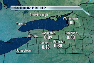
DECEIVING RAINFALL TOTALS

If you were to check out the rainfall totals as I have here you wouldn't think anything of it. A shower might have fallen. Whoo-d-doo! But boy, was the story quite the contrary.
This afternoon, just east of the airport, we saw some of the heaviest rain in YEARS in my (and others) opinion. The rain unleashed for about 45 to an hour, and I can tell you that I was one of several trying to wait it out in our parking lot until I gave up and got DRENCHED on the way in. One of our behind-the-scenes guys who lives close to the station said that this is the worst he's seen Humboldt street pretty much EVER! Radar estimates (yup, they can do that) are around 2 to 3 inches for some of the hardest hit spots, including northeast Rochester, Southern Irondequoit, Webster, Penfield, and Brighton. Had this dropped in the "official" rain bucket, we would have been talking about record one day rainfall for this date.
On the other hand, my lawn needed it badly. This marks only the second day that's delivered rain this month so far. With temperatures average well above normal, the lawns and shrubbery need all the help they can get.
Fun fact: This day last year, we matched our record cold temp at 48 degrees! Isn't it amazing the variability from one year to the next?!
No comments:
Post a Comment