WHICH WAY WILL WE GO?
Written by: Bob Metcalfe
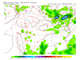
Two images, two models, two very different possibilities for late next week. As I said before, I'm scouring for reasons to mention our next cool down. It still ain't there. In fact, according to one of these pictures, it could get the warmest that we've seen it yet!
I'm super-excited that they have increased the ECMWF ("Euro") product suite on the Accuweather Pro site. This gives us a HUGE advantage in forecasting, as the Euro is known for beating up the GFS in the extended range.
So at left is Euro. It says upper 80s and possible showers next Friday afternoon. But the GFS, WOW. It's showing an incredible warm-up, where we'd at least see 90 if not warmer, and notice the storm right over the top of us. It would be nothing other than tropical and unbearable if that comes true.
This is the first hint at that scenario a la GFS, so I want more proof. But it goes to show you why you can't eat-sleep-breathe these things. Plus, I have a housewarming party of my own next Saturday, so I don't want it to rain (said in a pouty little 8 year old voice.)


It looks like we are never going to break out of this wet pattern this summer. Every couple of days it rains. Not just rains, it pours torrentially. We need some dry time. We could not get 1 storm to hit us during the winter, but in the spring and now summer it is one after another.
ReplyDeleteHousewarming party - did we move into a new pad Bob? ;)
ReplyDeleteRain? What rain??
ReplyDeleteNew pad in January, just now getting to the party!
ReplyDelete