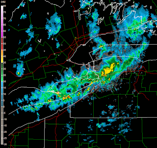
FOUR YEARS AGO TONIGHT & TOMORROW

Written by: Brian Neudorff
What an event four years ago tonight and tomorrow. To get 24 inches of snow in 14 hours was amazing for mid October. I know the Buffalo NWS office took a lot of heat for the blown forecast. They knew it would be historic but they didn't know how much it would be. In their defense I don't think anyone would have expected that kind of event. Especially when the largest single snowfall for October was six inches. Who would guess.
In 2006, I wasn't in western New York yet, but living in Erie, PA. I was watching the storm closely and since I lived 6 blocks from Lake Erie I could see the occasional lightning strikes from my window out over the lake.
My eyes were glued on radar as I watched this band of rain and snow continue to push into Buffalo. Then to see the amounts of snow and the damage this system did with all the leaves on the trees was amazing.
Although it didn't impact Rochester directly I can only imagine shutting down the NY Thruway around Henrietta caused some major problems. Like Erie, PA that saw many from Buffalo drive to get supplies and generators I bet Rochester saw the same kind of traffic.
Do you have an memory of that storm? If you do feel free to share it here.
The western part of our viewing area got hit quite hard. I lived in Batavia at the time of the storm. Batavia picked up over 1 foot of snow from the event. Most of the entire city of Batavia was without power. Side streets were nearly impassable. I recall walking down East Avenue in the city of Batavia and seeing folks just coming out of their homes on the morning of the 13th....Everybody looked like they were in a state of shock as they just stood around speechless looking around not knowing what to do or say. They were stunned.
ReplyDeleteMy greatest memory of that was the number of power lines that were draped across streets and houses nearly everywhere you turned. It was quite an event for Genesee county
An additional note to the above post...I remember fleets of power company vehicles passing through Batavia...I assume en route to the Buffalo area. They came through 10-15 trucks at a time. I saw on the Buffalo news channels (Batavia gets both Buffalo and Rochester news stations) that as the utility vehicles arrives, people stood street side applauding and giving peace signs....it was very moving.
ReplyDeleteI was amazed that a lake effect snowfall could be that significant that early in the season. Early snows like that are as bad as an ice storm due to the amount of foliage left on trees this time of year.
ReplyDeleteHere is the weather forecast from GFS
ReplyDeletetheweatherland
I don't recall the exact explanation of how such an event happened...but werent the dynamics with it absolutely unprecidented? As Brian mentioned, he could see lightning off shore....and i recall others saying how magnificent the lift was over the lake. Then you add on the VERY long fetch. Just amazing.
ReplyDelete