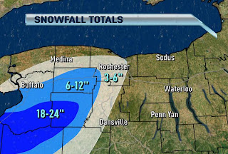
IMPRESSIVE SNOW AMOUNTS WEST OF ROCHESTER
Written By: Scott Hetsko
Single band lake effect snow often delivers snowfall rates of 1-2" per hour and occasionally thundersnow with enough instability. The map shows wide ranging snowfall amounts since the lake effect starts early Thursday. Southern Erie and Wyoming counties have seen the most so far with up to 24" of snow in a few towns.
What is interesting to watch this afternoon is not the Erie bands but the Lake Ontario single band now skirting lakeshore communities in Monroe and Orleans counties. Expect a 1-3" snow within a mile or two of the shore this afternoon, just enough to slicken roads and lower visibility. Subsidence from high pressure moving in our direction will pretty much shut down the lake effect guns by Saturday afternoon.

"subsidence"? or subsequent
ReplyDeleteScott,
ReplyDeleteLooks like Tuesday night into Thursday we might see some limited lake effect potential on a NW wind for a change. Do you think too much dry air will work in to give the Rochester area any chance of accumulating snow? I know last year that it seemed every time we had a favorable wind direction, and temps aloft were more than cold enough, it still didn't produce much of anything because of the dry air that kept working in every time.