IS EVERYONE FEELING BETTER?!
Written by: Bob Metcalfe
Hey all! First and foremost, I on behalf of the rest of the News8 weather team want to thank you for your overwhelming participation on the weather blog over the course of this storm. As Scott and Brian said before, you really are our eyes and ears, and this is the quickest, easiest, most efficient way for us to converse with you. We by far had the most reports, the quickest reports, and the most pictures of any storm since I've been here at WROC! For those of you new readers, I hope you continue to check in on a regular basis as well!
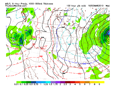
So now that the snow lovers got something, I'm going to be the bearer of bad news... again. This image is the GFS for Wednesday afternoon and wouldn't you know it... another storm misses to our south and east. A well-wrapped storm as you can see, that will bring more decent snow to the northeast coastline and pack some winds with it. We might see a few flakes out of it, but most notably gusty winds for the midweek.
Look to the west in this picture though. See the red hashed lines? That's the warmest air we've seen in the country in a long long time. One of our emails said they say 3 robins out in the yard yesterday. Spring?

Hi Bob,
ReplyDeleteDo you know if we hit 90" for the season, yet?
if u look on the forecast page it tells u how much snow for the month and the season
ReplyDeleteSome of the roads in Livingston County are very dangerous at this hour. I just in from Rochester and when I hit LC, it went from wet to very snow packed/slushy roads. St Rt. 256 is very bad with two wrecks on Conesus lake! Do they not plow after a certain hour? Please be safe folks. It is still snowing VERY HEAVY out here too.
ReplyDeleteNot at 90 yet. 88.5 We should break it tomorrow though!
ReplyDeletewill all this mess be melting fairly quickly, then?
ReplyDelete