
RUMBLINGS OF RUMBLINGS COMING SOON...
Written by: Bob Metcalfe
Monday's rain chances in the late morning are dismal. Our wickedly dry air will suck up all available moisture as things pass by, so only a LUCKY few will see wet stuff only briefly on the ground. 90% of you won't see/hear/smell/think rain on Monday.
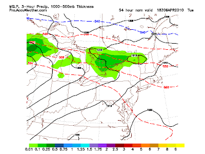
Tuesday's chances aren't great, but they do warrant attention as the potential for the Spring's first thunderstorm become possible. The image left shows late morning Tuesday bringing a weak-but-at-least-its-something amount of rain to western New York, barely. But within this airmass is indeed more moisture, a well developed warm southwest flow of air, and even a little bit of instability (read: rising air potential.) If the planets align correctly, and you put your right leg in your pants first on Tuesday, you might give us just the luck we need to see lightning/hear thunder. Anything would be short-lived and weak, and severe weather potential does not exist. But, it's at least something.
So dig up those SPC links and your favs for the summer, because before you know it, we'll be in severe weather season!
Would be cool to see some Lightning before I move out of NYS later this April! Bring it on!
ReplyDeleteWould these storms be the single cell, pop up variety, or would they be associated with a squall line forming ahead of a front?
ReplyDeleteHey Scott, still waiting to see Geneva on the weather map!!
ReplyDelete