
Bitter Winds with Lake Snows Slowly Diminishing...
Written by John DiPasquale:
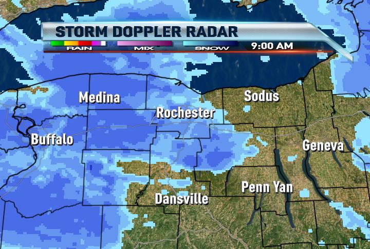
Hey finally something to smile about snow lovers. I know for most, it is not much, but at least it's an appetizer! Expect lake snows to wind down late today into early this evening due to some very dry air pushing in from the North & West with a small bubble of high pressure. Another coating to an inch or two will fall this afternoon before this happens though. Temperatures will hover within a few degrees of 20 through the afternoon with wind chills ranging from -5 to 10!
Late tonight the low & mid levels of the atmosphere will moisten up a bit more in advance of our next weather maker, a clipper. This should instigate a bit more lake snow late tonight into early tomorrow briefly & mainly Rochester North & East bound. Any lake snow will quickly move out of our viewing area early tomorrow & then a little general snow will arrive late in the day with the clipper. We could see a coating to a couple inches from late tomorrow through tomorrow night. Again, not a big deal, but could slicken the roads up a bit.
After a little sloppy system Friday-a little lake snow Friday night into Saturday morning & then a very mild start to 2012 it appears a BIG shot of arctic cold will blow in early to mid next week with potentially some significant lake snows! We'll see. Stay tuned.
Have a great night everyone & try to stay warm!
Finally the pattern change we have been waiting for is beginning. 1.5+ in up at highland and still coming down nicely
ReplyDeleteI would say we have a solid 2-3 inches here in Chili, but thats just a rough guess due to all of the blowing and drifting.
ReplyDeleteA dusting in Victor. NBD.
ReplyDeleteLooks to be about 2" in Gates. Blowing around a lot. Side roads are really treacherous as that rain froze in place. Main roads are OK.
ReplyDeletePlow guy came in Greece! Still coming down, although it doesnt show up on radar.
ReplyDeleteI am not sure but it looks like it will be really cold Monday and Tuesday next week. If I am looking at the data correctly there is a chance for big time LES for some areas in Rochester? Could the experts at news 8 chime in on that. Thanks
ReplyDeleteWhat wind direction are you seeing Andrew? If the wind direction is NW we could see good lake effect in Rochester. If it is WNW it will be Eastern Monroe into Wayne. If it is SW or West all bets are off for Rochester. It will be 50 on Sunday. Unbelievable.
ReplyDeleteIt looks like no storms next week now that we will have the cold air.
ReplyDeleteI wanna be back in Rochester^^ Over here in Germany some rain and 45°. Didnt get any snow up to now.... ahhhh
ReplyDeleteModels still showing some pretty cold air coming in next Tuesday and I believe the potential for pretty good lake effect snows. What does the News 8 team think about that?
ReplyDeleteAgree Andrew. Check out blog I just posted for more details. Have a great night!
ReplyDeleteJohn
The question is will it be Lake effect for Rochester or areas South and West or East of Rochester.
ReplyDelete