
Winds Slowly Ease, then Some Lake Snow

Written by John DiPasquale:
Cold winds continue to howl this afternoon, but are slowly letting up & will continue to do so as we move toward dinner into tonight. It will remain blustery tonight into Friday, but nothing like what we've had today thankfully!
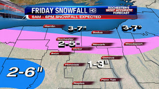
Later tonight into Friday we will be focusing on some lake snows destined for many. The heaviest, as typically is the case will fall up toward the lake shore during the period, but most should have at least a few inches of snow on the ground by day's end Friday. A trough is expected to pass through late tonight into early Friday morning which will bring the lake snows across much of the area during this time & should lead to a slick ride in for many Friday. Snow should taper some & shift to the north toward the lake later in the day into early Friday night, but then winds will probably become southwest in advance of a weak little clipper possibly pushing decent band off Lake Erie near or into the Greater Rochester area late Friday night into the start of Saturday. The snow should break up & dissipate during the day Saturday as the weak little feature crosses the area.
A stronger clipper, & one to watch, will then dive into the Northeast with some general snows, which should at least produce minor accumulations. Late Sunday/Sunday night into Monday morning it will turn colder with some lake snows probable. Stay tuned over the coming days, as winter flexes it's muscles some...
Have a great night everyone!
Boring fake lake snow
ReplyDeleteWith an ungrateful attitude like that you don't deserve ANY snow. Don't be a brat.
DeleteSo my house could see as little as 3 inches or as much as 9 according to this forecast. That's good ol' lake effect for ya. Hamlin Plower should be busy tonight and tomorrow.
ReplyDeleteI think we went over this before but without that fake lake snow we would average about 40-50 inches a year.
ReplyDeleteHmm---then let's drain the lake in Nov and fill it again in April.
DeleteBetter yet, just move to Florida.
DeleteSame old song and dance my friend.
ReplyDeleteLake Effect Snow Advisory just issued.
ReplyDeletehttp://forecast.weather.gov/showsigwx.php?warnzone=NYZ003&warncounty=NYC055&firewxzone=NYZ003&local_place1=&product1=Lake+Effect+Snow+Advisory
Doesn't say in the text, but the higher end of the range will probably be near the lake, with the lower end along and south of the Thruway, like what John stated.
This tells it all:
ReplyDeleteSNOWFALL (IN)
YESTERDAY 0.0 18.0 1966 0.8 -0.8 1.7
MONTH TO DATE 11.1 27.3 -16.2 19.9
SINCE DEC 1 33.7 49.1 -15.4 24.8
SINCE JUL 1 34.5 56.5 -22.0 25.1
SNOW DEPTH 0
Over 16" below normal for January. For the year we have had a wimpy 34.5 inches which is almost 2ft below normal. Last year at this time we had 25.1" Not much different. Another boring and snowless winter.
The difference is 9.4 inches, which is rather significant. We'll probably increase that number over the next 5 days. Besides all those numbers really say is that we've been below normal on snowfall. We still have all of February and some of March to make up the deficit, in fact based on Andy's research from the last thread history indicates that we will likely finish on a strong note. Even last season we had more snow in February than we did in the prior three months COMBINED.
DeleteAnd for the LOVE of GOD I'm getting pretty freaking sick of people making comparisons to last season. This season has been far different than last season, other than the first half of December. We've seen a pair of 2 week stretches with below average temperatures, one of which had well below average temps. Last season the longest such stretch we had was 5 measly days and it happened ONCE. We also had a major region-wide storm, which didn't happen last season. And we rarely saw the MJO enter a favorable phase last season, we've already seen it on several occasions this season. Don't even bother griping at me about still being way below average on snow, that is literally the only similarity between the past two seasons. The reasons for that are entirely different this go-around.
tl;dr snowfall amounts don't tell the whole story
Good I like boring. Maybe some more 65 degree boring is coming?
DeleteYep you are right anon 6:38 and there is no way around it. It does not look like anything is coming in the future either. The winter is over it is time to move on. It is so boring Scott can not even comment because he knows this pattern is bad for snow. Rochester and western NY use to be known for cold and snow in the winter. This is no longer true. And I do not want to hear about the LES snow becuase that impacts very few areas and people. So please do not give me those numbers as Scott says it is zip code snow. I care about synoptic snow that is what matters annd those numbers are pathetic.
ReplyDelete"And I do not want to hear about the LES snow becuase that impacts very few areas and people."
DeleteTry telling that to the folks in Buffalo. Or for that matter, the folks in Rochester. How quick you are to forget last February's event, or the two major events in December 2010. We receive 50 inches of lake effect on average, are you trying to tell me that half of our seasonal norm doesn't matter? Would you prefer that we scratched lake effect snow from the official records? Heck we may as well shave off some of the synoptic total as well, since the lake contributes a decent chunk there.
"It does not look like anything is coming in the future either."
I guess "A stronger clipper, & one to watch, will then dive into the Northeast with some general snows, which should at least produce minor accumulations." means nothing to you, since it is not the big honking blizzard many of us are hoping for. For the record, minor =/= nothing. It doesn't have to be a big storm for it to be "something."
"The winter is over it is time to move on. It is so boring Scott can not even comment because he knows this pattern is bad for snow."
Scott told us several weeks ago why he doesn't post. He was sick of getting chewed out by the peanut gallery for missing a forecast, besides John and Stacey do a good enough job keeping the blog up to speed don't you think? Look at the date...it isn't even February yet. Winters here last until St. Paddy's Day, do the math.
"Rochester and western NY use to be known for cold and snow in the winter. This is no longer true."
Holy melodrama Batman. Western NY has always been known for cold and snow, and it still is. Two consecutive weak winters, assuming this one goes down as such, will do nothing to change that. We've had more than 2 consecutive wimpy seasons in the past, just look at the 40s and 50s.
Now quit yer moping, it ain't good fer ya. The negativity here is getting pretty ridiculous.
This winter is wimpy and boring and VERY VERY VERY similar to last year. The ONLY difference is that this year is a little colder. January was 5 degrees warmer than normal and 16" below normal in snowfall. February will end up being the same. Warmer than normal and below normal in snowfall.
DeleteNo. Just, no. The upper air pattern isn't even remotely close to last season. Last season was dominated by a strong circumpolar flow and a persistent zonal jet stream pattern. This season has been back and forth between a western trough/eastern ridge configuration and an eastern trough/western ridge configuration. Two outlier-ish warm days (2 days above 60 this January compared to none last January) skew this January's numbers. Take those away and you have a temp departure of +3.2, significantly lower than last January. Last January featured just 2 days with double digit negative temp departures, this January we've had 5. Last January was persistently mild, this January has featured wild temperature swings from bitterly cold to downright balmy. Not to mention that the snow distribution has been completely opposite to last season. We've had a normal December and way below normal January this season, whereas last season December was low on snow while January was near 20 inches. Also not to mention that the circumstances leading to wimpy January snow have been far different than last season (cold airmasses being too dry as opposed to being too warm). I'm not trying to sugarcoat the reality, which is that we're still running well below normal on snowfall. I'm just sick of the comparisons to last season when a little research reveals a completely different story, despite the overall numbers being somewhat similar so far.
DeleteThe only thing convincing you that February will be another lame month is your own negative attitude. History tells us otherwise. As Andy's research reveals, the second half of winter tends to be much snowier than the first half when the first half runs well below normal. Even the wimpy time of it last season had a February that featured ABOVE AVERAGE snow, more in fact that the prior three months COMBINED. This is not a forecast, nor is it me claiming to know what will happen. None of us know, including you. What we DO know is that history is on our side. So quit being a Gloomy Gus and learn some friggin objectivity.
There's a LES band right now extending from Grand Rapids Michigan all the way to the middle of Massachusetts - hard not to count that, it's gotta be close to 20% of the length of the continental U.S. I think LES is more interesting because it's unpredictable and I also enjoy the days that are both sunny and snowy. I wish we could get rid of that piece of Canada and turn Huron/Georgian bay and Lake Ontario into one big lake. Then we would get pounded every year.
ReplyDeleteBy golly gee wouldn't that be great fun.
DeleteThe snow band is coming ashore strong over Orleans County but totally weakening over Monoroe county and east. Typical. Maybe an 1-2 in Monroe. What will we do it with it all????
ReplyDeleteI have about 4" in my driveway and I'm half way down Monroe County-- still coming down. Yuck.
Delete8-14 temp ooutlook from the NWS. Well above normal. February will go down aws above normal temps and well below normal snow. This year WILL end up with less snow than last year. NO DOUBT!!!!!!!
ReplyDeleteI hope you are right but I do not share your confidence. Monthly forecast for Feb is normal/ normal and I think that will occur especially after Jan and Dec both being +5 F. 20+" in Feb--you watch. Today's little fun and games is going to be 4-5" alone--on 2/1.
DeleteI just hope the misery ends as quickly as they are predicting with a rapid and significant warming going into March.
Agree with Anon 4:24 and sick of Anon 7:26 with his stats that this years winter is not like last years. Poppycock! This winter is worse than last year and we will get less snow for the season. February predictions are above average temperatures and minimal snow. The LES as usual is a joke and only a few people receive it. The winter is horrible so stop trying to justify as anything other than waht it is.
ReplyDeleteActually NWS forecast is for normal/ normal temp/ precip for Feb.
DeleteThat band totally weakened. Only a few flurries here in Western Wayne county by Penfield. I do not want to be negative but this winter has turned out to be VERY disappointing once again. I really hope this is not the pattern for our winters. I know history shows this has obviously happend before so we will see. I really thought this winter would be different but it is similar, in regards to snowfall, to last year. It has been a colder winter but that is the only difference. With no storms in January and none in sight for the next week or so this winter may be lower in snowfall than lasy year. We will see. We are supposed to get back near 40 by mid- next week so it does not look to good.
ReplyDeleteI don't want to be negative but, I hate this blog and everyone here sucks. BTW, I am a liberal.
ReplyDeleteSpring is here again temperatures on the rise mid to late next week with no big snows in sight. Looks like the troll has been right all along. It said above average temperatures and less snowfall than last year. It is looking good on both accounts. January, the month that all snow and winter mongers, want to paint as really cold was above average for temperatures. The extended forecast for February, that all snow and winter mongers want to paint as catch up month based on history, shows increased temperatures and little snow until at least mid month. March and April are predicted to be well above normal in the temperature department. That time has ran out for you snow/winter mongers. Kudos to the troll it rocks!
ReplyDeleteI do believe the most annoying phrase is "Spring is here". Just because we have little snow and slightly above temps in the future does NOT indicate spring. It sure does stink for us snow lovers, but spring??? Really?? Spring to me is 70 and above, flowers, and mowing lawn. This is NOT spring!!
ReplyDeleteVery high standards for spring especially for Rochester. Spring for you is end of May.
DeleteFirst sign of consistent mud and constant rain says it's spring for me.
If we are going to believe long range predictions it could be miserable. Unless you like slop storms and cold rain mixed with snow at times. Polar air shifts to the other side of the globe but we get a -NAO... that doesn't scream sharpen the mower blades to me. It just says blah.
ReplyDeleteAs long as it doesn't snow ........
DeleteYup, I agree, spring is definitely here!! 6 inches of new fluff on the western part of the city with a windchill of a whopping 7. Looking forward to more lake effect fluff!!!!!!! The spring mongers are either instigators or real unintelligent. Either way, they look like baboons this morning.
ReplyDeleteHow about the eastern part of the city? Do they count? The point is we have had one synoptic (that is for all) snow event that had any importance. So stop hiding behind the lake effect snow because it only impacts the very few.
ReplyDelete700000 people. That's how many got a dose of lake snow this morning.
DeleteOh. My. Freaking. God.
ReplyDeleteI don't think I've ever seen a mopier bunch of sad sacks than the group on this blog. "This year WILL end up with less snow than last year. NO DOUBT!!!!!!!" This has GOT to be the stupidest thing I've read here in awhile other than the posts from the spring troll. Not the notion of getting less snow than last year as much as the notion of that idea being a guarantee. Making any guarantees about winter's final stretch is nothing but crockery and foolishness, and guaranteeing negative outcomes does nothing to make you feel better (believe me I've been there before).
Anon at 4:13...correct me if I'm wrong but it seems like you weren't expecting the band to weaken as it moved ashore. When the wind veers and the fetch shortens, that is exactly what happens. Not like it wasn't anticipated from the onset.
Anon at 6:22...your whole post is just completely ridiculous. I was the guy who posted all the stats and followed it up with "I'm not trying to sugarcoat the reality, which is that we're still running well below normal on snowfall. I'm just sick of the comparisons to last season when a little research reveals a completely different story, despite the overall numbers being somewhat similar so far." But apparently you skipped right over that statement and went straight to attacking me. No one with 3/10ths of a brain is denying that the numbers are similar, but THE WAY WE GOT THOSE NUMBERS IS DIFFERENT, FROM A PURELY METEOROLOGICAL STANDPOINT. Hence the frustration over comparisons to last season. "This winter is worse than last year and we will get less snow for the season." See above for my rant on statements like this. "The LES as usual is a joke and only a few people receive it." The lake snows affected all of metro Rochester early this morning, but I guess 700000 people is "only a few." If you want to play a numbers game we're actually doing better than last winter on all counts.
Macedon...oh Macedon...you're not being as blatantly negative as some other twits here but please, keep your chin up.
Later next week should bring us a return to above average temps for several days followed by what APPEARS TO BE a return to seasonable by mid month. Looking at the NAEFS 8-14 day temp anomaly shows the milder air being progressive in nature, with neutral anomalies following behind. The Euro Weekly model, whose track record has been dubious this season, is showing the coldest arctic air moving back to Siberia. That does NOT mean it can't snow around here. We saw a similar situation last February and we ended up with more snow than average for the month. I am NOT MAKING ANY GUARANTEES, unlike some of you who are utterly convinced of the worst possible outcome. That's what is most annoying, all the baseless guarantees being made by sad sacks. I came here expecting to read some snow reports and expressions of joy about how it snowed AT ALL, even if we didn't quite reach the forecast amount. Instead, all I got was whining and moaning.
Now that I'm done fruitlessly shaking my e-fist at internet strangers, it's time to resume my snow dance...