
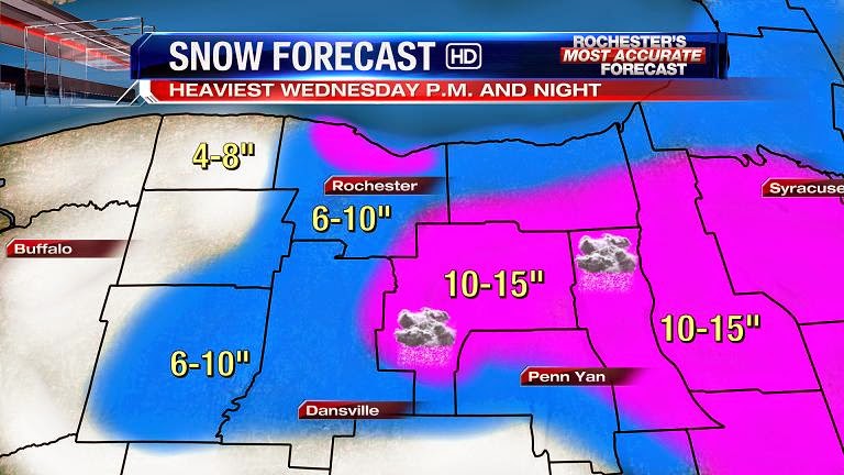
AREA WIDE PLOWABLE SNOW FOR ROCHESTER
Written By: Scott Hetsko
There are a few things I'm uncomfortable about with this upcoming "storm". Not much cold air to work with until storm is moving away from Western New York. This isn't the best lake enhancement scenario but there's some there. The thing that will be critical is how much snow gets thrown West when the storm is in it's cyclogenesis stage Wednesday PM and night. If that snow makes it to Western NY then my forecast below will be on target. Of course we'll have an update on these numbers tomorrow.
No matter what, at least a plowable snow fall is coming. Enjoy!
I think the air is going to be colder than predicted through the duration of the storm. I see 10-14 inches from the metro south by Friday morning.
ReplyDeleteTaking bets on the number of "bust" posts when the weenies wake up to less than a foot of snow Wednesday morning.
ReplyDeleteOver/Under is at 5
ReplyDeleteI think the number of people calling bust is closer to 20.
DeleteNo bust it was never a big storm. The Oz GFS has us 6-8 inch by Thursday night. range oh well throwing in the towel.
ReplyDeleteYou heard it here folks, a single run of the GFS is still showing a mere significant snowfall instead of enough snow to bury my car, so clearly it isn't worth tracking anymore.
ReplyDeleteAm I doing it right?
No. You're supposed to be anonymous.
DeleteI'll do better next time sensei ( ._.)
DeleteI love how everyone talks as if the storm has died. 24 hours before it even begins.
ReplyDeletePersonally. I think there is a 1 in 3 chance snow gets thrown a little farther west or stalls a little longer and we get a legit 12 or 14 at the airport.
Not the most likely scenario. But it's fun to entertain. Especially in early December.
For the record. I have no basis for this opinion other than that's potentially a long time to park a storm, no matter how modest or marginal.
Put me down for 9.7" at the airport Wed/Thur total.
And I think it will be cement snow.
I've got 8.4" plus one lonely raindrop.
DeleteMy guess is 6.4" at the airport when all is said and done.
ReplyDeleteModels over night show no change. Should see 6-8 inches by Thursday at noon.
ReplyDeleteWinter Weather advisories posted. Not enough snow to warrant WSW. This will be a light snow for us considering it is over a 48 hour period. I am hoping for the BIG one sometime this year. Lets enjoy what we get in the meantime. Who knows maybe we will get a surprise with this one. It has happened many times before.
ReplyDeleteWhy would anyone hope for a "big one" the likes that Buffalo and those to the West experienced several weeks ago.
ReplyDeletegr8b8m8
DeleteWhich weighs more: a pound of warning snow or a pound of advisory snow?
ReplyDeleteI asked my mechanic when he was changing the summer air in my tires for winter air. ;0
DeleteCCCC is up early tracking it all. What did the over night models show the same?
ReplyDeleteBasically.
DeleteI'm not up early for tracking purposes by the way...
time to cut these numbers in half....
ReplyDeleteWhy anon 9:49 evidence please.
ReplyDeleteI don't care how much snow we get as long as I don't have to look at the spot in my yard where the neighbors let their dog poop because they didn't think I was home...
ReplyDeleteweather.gov says for Avon: tonight acc. less than 1" possible. Wednesday new snow of 1-3" possible.
ReplyDeletewhooppeeeeeeeeeeeeeeeeeeee....
I think Scott's totals are gonna come way down by tonight. He is way off base with those projections. I'm not certain much of Western NY even sees snow, let alone a few inches. What a bummer...NBD for this one..
ReplyDeleteThe above Spreadsheet Guy is not me. I just felt the need to defend my honor. Now I know how Snowdog feels. For the record. I completely disagree with imposter Spreadsheet Guy. I would be shocked if we don't wind up with at least plowable snow. I'm still hold out for my prediction of 9.7" at the airport.
DeleteThis storm is going to push East a bit more than predicted. Yes, it will be a plowable snow, with most falling Wednesday during the afternoon. I will be surprised if the West side of Rochester gets 6".
DeleteMy prediction for the official amount at the airport - 5.6". Mark my word!!!
BUST BUST BUST!!! Was all hype as usual
ReplyDeleteHey... WSW was just up on the wroc page. This is new...
ReplyDeleteWSW not for out area and deff not new. It was posted yesterday at like 2 pm.
ReplyDeleteWhat is going on here? Why is everyone jumping ship? The storm was not suppose to even be here until tomorrow? What are all of you seeing?
ReplyDeleteWhere is CCCC and is it true that this storm is done like many have posted here?
ReplyDeleteThis comment has been removed by the author.
ReplyDeleteThis storm isn't expected to arrive until tomorrow morning and everything still looks on track. The numbers that Scott posted still look on target as of late this morning.
ReplyDelete-Matt Jones
When will it arrive in the Southern Tier? Our Mets said this afternoon, but I see nothing on radar
DeleteEveryone is saying its a bust and jumping ship quickly, even the great KW. NBD on this one...sigh.
ReplyDeletehttps://twitter.com/whec_kwilliams/status/542345719815090177
Delete"Midday data rolling in but so far, like where we are...6-12" for ROC region Wednesday - Thursday...highest in hills w/ lake enhancement ?'s."
More like jumping from one part of the ship to a different part...
Can people not ask "where is CCCC" for every three hour period that I don't post here? There's this thing called "a life" that I engage in sometimes...
ReplyDeleteIf Matt says everything looks on track then I choose to believe him. None of the modeling has shifted substantially anyhow. Some of the high-res guidance actually looks pretty intriguing, but consuming too much high-res eye candy can only lead to ulcers.
Who is Matt? And should we believe him CCCC??
Delete...are you serious
DeleteNews 8 Weather December 9, 2014 at 11:30 AM
This storm isn't expected to arrive until tomorrow morning and everything still looks on track. The numbers that Scott posted still look on target as of late this morning.
-Matt Jones
Whoops! sorry, I saw the icon as Scott and though it was him haha.
DeleteSoo...who is Matt though?
Again CCCC do we look at the 12z Euro and put any stock in what it shows?
ReplyDeleteNot too piggyback off all these NBD comments, but this is indeed moving more East than we had hoped. 4-6" looks like a safe bet and totals will probably come down. So as others would say, NBD on this one unfortunately.
ReplyDeleteThe above post is the FAKE Snowdog.
DeleteCCCC is this system going to retrograde or no? How much snow will we end up with? Thanks!
ReplyDeleteSo lets just ignore both KW and Matt Jones saying that things appear to be on track...
ReplyDeletehttp://i.imgur.com/Zb70vnX.gif
Have you seen the radar CCCC? Its not going to spin back to us...
DeleteYou mean, have I seen the simulated radar which entails more than a layman's eye test? Because every simulated radar I've seen still shows a backlash happening.
DeleteWho is Matt Jones???
DeleteYes I would have to agree with Snowdog it is not coming west and it is not far reaching on the backside with the snow. Scott did say the numbers would come way down if the wrap around did not come far enough west. 3-5 for entire deal. Oh well plenty of winter left.
ReplyDeleteExactly my point. I just don't see the wrap around happening. Looks like a lot of WNY could stay dry even. NBD sorry folks..
DeleteBUST! I knew it all along and I'm not even an expert! NBD is correct
DeleteMaybe we'll even get negative snowfall...
ReplyDeleteNone of you are legitimately serious right now -_-
People are freaking out over this storm behaving exactly as it was supposed to behave. I can't wait to see the collective meltdown when we experience an actual bust one of these days...the ensuing mushroom cloud will be visible from China.
ReplyDeleteI will say this the storm is actually stronger than predicted at the current minute. Also there is a HUGE amount of moisture coming up from the gulf/Atlantic now starting to catch up to the storm. There was no sub tropical jet to get it there before but it is coming. If the track is good and it retrogrades back watch out IMO.
ReplyDeleteDidn't get to look at much modeling difficult to do at work but what I see looks good. It looks like the 10-16 could be extend a little further west into Orleans county, due to enhancement.
ReplyDeleteRGEM radar loop:
ReplyDeletehttp://collaboration.cmc.ec.gc.ca/cmc/cmdn/pcpn_type/pcpn_type_gem_reg.html
The first bit will be enough to make your anus clench, but it all turns out fine in the end. I'm of the opinion that this whole model suite has been garbage so far, but its high-res component beautifully illustrates how the deformation zone will work its way westward across the region.
Good lord, that looks like were gonna get smacked good! Is this legit?!
DeleteWho's Matt and where is CCCC for the latest?
ReplyDeleteI think its a made up name...I've never heard of Matt either
DeleteIf the name isn't Scott or Stacey it must not exist since they are the only ones listed on this page! I think this Matt character is an urban legend.
DeleteMaybe someone hacked the news8 account LOL.
DeleteWho is this Matt character?!
Ok the storm is definitely coming people. The NBD comments are a bit much.
ReplyDeleteCCCC do you think the deformation zone around the ridge will get looped in around the wrap-around when sega genesis starts to kick in around this evening? Will there be enough moisture/cold air to support it? What is your analysis?
Reading all this " stuff " gets us snow plow contractors confused and frustrated.
ReplyDeleterc was not giving any totals, just saying wet, heavy snow. No inches mentioned in his forecast on 10. Says the totals will be impressive, but not a big deal, given the longevity of the storm.
ReplyDeleteRemember this storm is slow and going to be a long duration and does not start until tomorrow here. Again look at the BP of the LP right now much stronger at this point then the models predicted. I think CCCC showed the link with that deformation zone and how it works back West. I think we are underestimating this storm and forgetting about the winds with it. Look at how tight the isobars are on the model.
ReplyDeleteAnon 1:57 you are wrong this is a bust in the works maybe 3-5 inches total. Not sure what you are looking at and sounding like we will get a foot plus.
ReplyDeletemm on 13 is saying things like "very manageable" maybe an inch overnight, maybe about 6-10 total... all melted by this weekend or early next week when it is near 50...
DeleteMatt is the new Met. Welcome to Rochester, Matt. Not everyone here is a jerk.....
ReplyDeleteI don't believe you
DeleteLies!
DeleteGoing to start snowing lightly here about 7:30 tomorrow morning and light to moderate all day. The heaviest band will set-up from 4:30 to 8:30 Thursday morning when it could snow pretty good. Then real light rest of the day.
ReplyDeleteMany areas in Pa. down graded to WWA from warnings. Can you say bust?
ReplyDeleteMatt is the newest member of 8's Weather Team -- so if you happen to be watching their morning show; you will see him. Must be I am the only one up at 4:30pm each morning getting ready for work. Have to say that it is getting very confusing on this blog as when you ready the WSA it states:
ReplyDelete1" or less over night (Tuesday night)
2-4" Wednesday during the day
2-4" Wednesday night
Up to 2" Thursday
Though I was hesitant to believe it 10 does hype up the weather forecast to get you nervous about the weather conduction -- significant snow, will impact and make travel difficult. What will be challenging on Wednesday is not only the snow, but the winds which will cause blowing snow and decreased visibility. Have an important meeting on Thursday so to say that significant amount of snow will occur early Thursday morning on 10; when the 13 and 8 are not. 10 is just being irresponsibly at this point in with the words and phrases they are using.
Farmington post about was not me. Some people have no life or too much time. I won't post for a while. If it says Farmington it won't be me! This became a total joke, thanks people.
ReplyDeleteIts amazing how many Anonymous posters just want to "stir-up" the pot. Thanks to CCCC, the "real" Snowdog, and Channel 8 folks for keeping this blog up to date, and informative. As far as the storm, last night at 5pm, Scott said, one of his meteorology professors used to say (with a forecast like this), one won't know what happens until it actually happens!!
ReplyDeleteIf you look at the latest imagery, the storm is nearly stationary but the wrap around is ever inching so slowly east. I really believe we will not see much here. We will be just skirting it.
ReplyDeleteScott just adjusted some of his numbers -- still 6-10 inches for Rochester. Everyone needs to keep in mind that this is the TOTAL amount of snow for Wednesday thru Friday morning -- not all on one day. 3-4 inches per day -- we all can handle. Again, more concerned with the wind forecasted for Wednesday, will make driving challenging.
ReplyDelete