
Coldest Air of the Season Looms
After a relatively mild weekend, the large scale weather pattern will undergo some big changes across the country this week.
A large ridge of high pressure will build over the west while at the same time, a deep trough of low pressure will form over the Northeast. This will allow cold air that is currently building in northern Canada to spill south into our region by the second half of the week.

The first surge of Arctic air will arrive Wednesday night into Thursday with highs Thursday struggling to climb into the mid teens. This cold air combined with a northwest wind direction will help generate lake effect snow squalls along the south shore of Lake Ontario, including much of Monroe county. It's still much too soon to say how much snow we'll see but several inches of fluff will be possible.
The second surge of Arctic air will plunge south by the weekend bringing the coldest temperatures we've seen in about a year. Several reliable forecast models we use are showing some truly bitter air arriving.
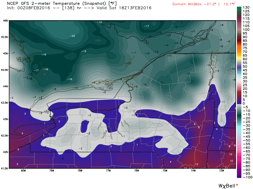
The GFS model is showing highs not even climbing above zero by Saturday afternoon!
The ECMWF model shows highs barely climbing into the single digits.

Factor in the wind and wind chills will plummet 10 to 20 below zero at times. Bottom Line: this will probably be the coldest stretch of weather this winter and we'll likely see several inches of snow piling up from Wednesday through the weekend.
Stay tuned for more updates!
Written By: Meteorologist Matt Jones
So winter will finally arrive and be gone in about a week's time. Sounds good to me! Sorry folks, but no snow storm with this one! Absolutely NBD
ReplyDeleteMy students convinced me to do that Polar Plunge on Sunday. I'm thinking that's a dumber decision than usual.
ReplyDeleteWe know. You told us 15 times in the last thread..
DeleteOnce actually. But I'm just trying to tell people while I can still speak.
DeleteDid you check the last thread fifteen times looking for a big storm?
Nope. There are no storms this winter, sorry bub! I heard you're doing the polar plunge, is that true?
DeleteYeah cold temperatures for 2 days next weekend. Big deal for us this winter but still not a snow storm in sight.
ReplyDeleteThey said for the 7,323rd time.
DeleteI think I am going to be screwed for this Polar Plunge that I am doing!
DeleteI heard Spreadsheet Guy is doing the Polar Plunge this weekend!!
ReplyDeleteYes, I am doing it on Saturday. But I'm thinking it's not the best decision because its going to be so cold now, ugh! What do you guys think I should do?
DeletePrepare for life as a human icicle :P
DeleteCCCC do see anything out there on the models that even gives a slight hope for a major storm in the future?
ReplyDeleteI'm pretty much focused exclusively on this week. There's been talk about the period just after Valentine's Day but things are still very nebulous, as you might expect. Haven't really looked into it much.
ReplyDeleteThere really is not much this week is there except strong cold on Saturday and Sunday. The LP system is really nothing correct? Are there any signs of significant LES any where?
ReplyDeleteNot really significant but also not negligible. We're going from synoptic to lake enhanced then over to pure lake effect.
DeleteI wish I was doing the Polar Plunge during a snow storm rather than the freezing cold this weekend!
ReplyDeleteOMG give it a rest! We all know you're doing the Polar Plunge!
DeleteLMFAO about the Polar Plunge
ReplyDeleteMore like Polar Funeral. RIP in peace SG.
ReplyDeleteJust imagine the irony if the polar plunge has to be rescheduled because it's too cold outside. Especially in a tame winter like this one has been.
ReplyDeleteCCCC when is the timeframe for the more significant LES opportunities?
ReplyDelete"More significant" is a pretty ostensible phrase here, but the answer is during the weekend. Limited moisture will be a substantial drawback in such a cold airmass, hence why "significant" isn't really an applicable term.
ReplyDeleteDo you think they will issue any LES Advisories or Watches? I would imagine for the weekend there will be Wind Chill Warnings, especially if the wind begins to pick up. Heard that some are predicting wind chills in the negative 20 to 30 range.
DeleteCan't say at this range if there will be any lake effect headlines. Pretty likely that we see wind chill headlines though.
DeleteI thought LES threat would be Wednesday night into Thursday?
DeleteThat's the lake enhanced snow.
DeleteOh Polar Vortex, how we have missed you!
ReplyDeleteI'm still going through with the Polar Plunge no matter how cold it gets!! I'm doing it this weekend
ReplyDeleteWe know.....We know....Relax man
DeleteJust wondering about that blob of moisture the 12z GFS spits over us Monday / Tuesday 2/15 and 2/16. I realize that's still far out but I'm trying to learn more about modeling...would that be termed a "clipper" or is there more going on there?
ReplyDeleteSW
It definitely looks clipper-ish.
DeleteJust curious, anyone ever done a Polar Plunge before? And if so, how was your experience and what was the temp? I am doing my first Polar Plunge this weekend, in probably single digit weather!
ReplyDeleteI think George Costanza had a bad experience with cold water :)
DeleteSG 3:01 -- troll get off the page.
Delete1. 7:37 and 9:21 were me. The rest were not. I feel like snowdog getting impersonated. I guess that's what people do when they get snow starved.
ReplyDelete2. Too bad the impersonation is more interesting than the snowcast. But maybe we'll get pleasantly surprised by the lake.
I wonder how many days HP has been out this year? vs a regular year? vs last year?
Figured it must of been a troll as you usually don't obsess about silly things like this.
DeleteSo when they say "Snowy North" -- are they predicting more snow north of the Thruway or north of 104. Trying to figure out travel plans for Thursday. Appreciate any insight. Thanks.
ReplyDeleteProbably Thruway since the flow will be largely NW on Thursday. Can't see NW flow LES hugging 104 unless the wind is really really super light, which doesn't appear to be the case.
ReplyDeleteNorth American snowcover at its lowest level in a decade.
ReplyDeleteWe received our first installment of an inch last. Whooo hooo.
ReplyDeleteA high of 3 on Saturday... Burrr!
ReplyDeleteThe ground is white. It's a start
ReplyDeleteWhat are you seeing as to snow amounts for Wednesday leading into Thursday?
ReplyDeleteModest at best. Near the lake-3-5. Every where else 1-3.
ReplyDeleteThanks appreciate it.
Delete4 more days until I take the Polar Plunge...I think I'm going to regret this decision...High might be hovering around zero!
ReplyDeleteOMG WE KNOW!!!!!
DeleteI agree, we all know by now that you're doing the Polar Plunge. We hope you have a fun cold time, but stop talking about it already! Sheesh!
DeleteSG 7:29 -- we all know you are a troll. So lets drop it about the Polar Plunge. Here's a new concept -- move onto another story.
DeleteActually above post is indeed me, but not the others from yesterday!
DeleteWhat day is the Polar Plunge? Haha
ReplyDeleteThe Polar Plunge is this weekend, and its going to be cold! Did you know that I am doing the Polar Plunge?
DeleteGuess what no storm again next week. We will hear towards the end of the week the conditions for a storm are there for the following week then that week will come and then the next etc etc etc...
ReplyDeleteAnybody doing the Polar Plunge this weekend?...Anybody??
ReplyDeleteYes, I am doing the Polar Plunge. What's the big deal?
DeleteSG they are bating you about the Polar Plunge, don't fall for it!
DeleteWonder if the Polar Plunge will be cancelled because of the extreme cold? Ahhh the irony..
ReplyDeleteIt was great and very classy the segment that Channel 13 did to welcome back Scott to the air; however, did anyone see if Channel 10 did anything? Even the CBS Morning news show had a segment to welcome him back. Speaks volumes as to the respect he has among colleagues and competitors.
ReplyDeleteI didn't see it, but agree that is very classy. So glad to have him back with us! Did they do a segment about the Polar Plunge at all?
DeleteThere will be a polar plunge in the flower city within the next 5 days mark it down!!!!!!!!!!!
ReplyDeleteLMAO YES!!!
DeleteStacey tweeted still looking for accumulating lake snow east and SE of lakes Erie and Ontario. Does anyone know if that includes Monore County or just areas north of 104?
ReplyDeleteIt does NOT include Monroe County, unless you're talking about the Polar Plunge. But don't let Spreadsheet Guy hear you..
DeleteSomeone say Polar Plunge? :) I am actually doing the Polar Plunge this weekend in case you didn't know!
DeleteHoly cow is this entire thread about the Polar Plunge or what??!
ReplyDeleteI blame Spreadsheet Guy!
DeleteHow is it my fault? Just because I am giddy about doing the Polar Plunge this weekend??
DeleteKeep in mind the one who keep posting about the Polar Plunge is now the real Spreadsheet Guy -- it is a troll and should be ignored. Read previous posts about this.
DeleteDUDE NO ONE CARES THAT YOU'RE DOING THE POLAR PLUNGE OMG!!!
DeleteSo now that I'm done losing slightly more faith in humanity from reading these comments...I'm a bit perplexed by the AFD painting 2-4 inches for both the lake effect areas (yes that includes Monroe County) and the non lake effect areas. I'm also a bit perplexed by their thought of a Huron connection affecting the lake snows west of here on a 290 flow. Something about that doesn't sit right with me, if anything that should be the case east of Rochester and not west. Oh well, it's not a big storm so why should I care anyway :P
ReplyDeleteBy the way, those numbers are just through Thursday. The AFD also mentions the possibility of a snow squall Friday afternoon with the arctic front but we've seen that the reliability of those things is questionable at best.
ReplyDeleteThe beat just keeps going on and on. We just can not get a substantial snowfall. Seriously I am just ready and now hoping for an early spring.
ReplyDeleteYeah. This lake effect will not be a big deal as the air will be too cold to produce heavy snow. A few inches here and there at best. I am glad the bitter cold is fleeting. I hate bitter cold. Still no storms in sight. Hard to believe not one synoptic storm for us tis winter. Wow. Almost 40" below normal in snowfall. We are not the only ones. The whole NE is pretty much way below normal.
ReplyDeleteEl Nino the king of ruining the NE winter weather. Hail to the king!
ReplyDeleteWow now Saturday will struggle to hit 2 degrees! Maybe not a ton of snow except east end of lakes but at least it will be white and cold.
ReplyDeleteFor those wishing for early spring, I have a hunch that isn't happening.
Why is anyone still acting like this week being almost entirely light snow is a new thing?
ReplyDeleteBecause people like to complain.
DeleteI'll just be happy it's cold with some white, because it beats the winter alternative of rain, brown and mud.
Early/mid next week looks like the next period of synoptic interest BTW. Feel free to draw as many of your own conclusions from that information as you'd like.
ReplyDeleteAnd cold enough to support snow... Let's hope.
Delete12z Euro sure did look interesting for next week but the storm last wee for this week did also. One has to work out for WNY doesn't it?
ReplyDeleteThankfully, this cold looks like a brief hiccup and we will be back to above normal by mid to late next week. It would be nice to melt it all ASAP.
ReplyDeleteActually been out on the golf course a couple of times in last week. Not exactly pleasant but way better than being house bound like last year.
So far so good.
The ensemble means rebuild the west coast ridge pretty quickly after next weekend, so any warmup that moves in also looks brief.
ReplyDeleteMid to upper 30s next week... Hardly a warm up.
ReplyDeleteBetter than 5- 10 and snow.
DeleteThe mean flow this week will be WNW which takes most of Rochester out of the lake effect which is why we are not in an advisory. The beat goes on.
ReplyDeleteLet's try this nifty thing called "reading the AFD."
ReplyDelete"LOCALLY HEAVIER SNOWS ARE POSSIBLE WITH A GEORGIAN BAY CONNECTION IN NIAGARA/ORLEANS/MONROE COUNTIES...BUT FORECAST CONFIDENCE IS SHORT OF ISSUING HEADLINES FOR THESE AREAS."
http://forecast.weather.gov/product.php?site=BUF&issuedby=BUF&product=AFD&format=CI&version=1&glossary=1
I think there might be a slight difference of opinion between BUF and BGM...
ReplyDeletehttp://www.weather.gov/nerfc/snow
Well we have been disappointed all season with lake effect underperforming for us so I don't see this being any different. I think we will all see a few inches and then the 104 corridor east will see a bit more.
ReplyDeleteI think it is funny that they are always confident about lake effect East of us and South west of us all the time, but when it comes to Monroe county and Orleans they are never confident ever. It usually takes the snow to start falling before they issue any advisory.
ReplyDeleteThat system next week looks very week as well.
ReplyDeleteweak
DeleteYeah it's weak if you take the GFS verbatim, which as we've seen over the years is never a good idea. Lots of much stronger solutions among its ensemble members as well as the GGEM ensemble members. The Euro ensembles have even more strong solutions plus the operational sends a 980 mb low up into SNE, which is also pretty close to what the GGEM has. The JMA has a track from OBX to near ACK at a central pressure of 993 mb. And even the 12z NAVGEM looks like it would produce a strong low if the run continued (18z only goes out to hr 144 but looks similar to 12z through then). The GFS, with its much weaker low well offshore, is currently somewhat of an outlier. I'd actually worry more about too much of a west trend than what the GFS is selling, although neither outcome should be entirely ruled out.
ReplyDeleteAnd on the topic of "underperforming" lake effect, our warned event in January verified pretty well for most areas, and the one afterward was a bonafide overachiever. These things don't always bust, actually I'd say they bust far less frequently than some here seem to think.
ReplyDeleteTrue. I don't have the freakish photographic weather memory of CCCC. But I distinctly remember thinking a lake event over performed last month. Nothing crazy. But several inches more than anticipated.
DeleteIt did over perform.
DeleteDoes not look good for the system next week. Models are trending much weaker and way east and south of us.
ReplyDeleteLet the wimpy Rochester lake effect begin.
ReplyDeleteLES Advisory up for Monroe County.
ReplyDeleteHow come the morning weather folks are all over the map as to how much snow we will get: 1-3; 2-4; 6-8 by Thursday morning -- which is correct.
ReplyDeleteMost likely 1-3 for most of us. North of rt 104 2-4 and then 6-8 Northern to Eastern Wayne county.
ReplyDeleteThank you; appreciate it.
DeleteOnly 3 more days until I do the Polar Plunge! In sub-zero temps likely..
ReplyDeleteWe know this already. Please stop telling us.
DeleteAnybody have any idea on the timing of this from the NWS?
ReplyDelete"LAST BUT NOT LEAST...A POWERFUL ARCTIC FRONT WILL SURGE SOUTH ACROSS
THE REGION FRIDAY EVENING. THIS ARCTIC FRONT WILL LIKELY CAPTURE AND
MERGE WITH THE LAKE EFFECT SNOW BAND OFF LAKE ONTARIO...WITH A VERY
HEAVY SNOW SQUALL PASSING SOUTH ACROSS MUCH OF THE REGION."
I'm driving south beginning at 3:30 Friday trying to get to Maryland for the night before continuing on. Don't really want to deal with this on the way.
Seeing as how it says Friday evening I would think if you were heading south at 330pm you would be totally fine. Further from the lake the better.
ReplyDeleteNo one has mentioned this for Friday evening? Why no mention from local weather folks.
DeleteSignificant snow expected for Friday night -- what are the amount anticipated?
DeleteLES Advisory upgraded to warning.
ReplyDeleteLES Snow updated to Warning now. Confusing when you read the alert. How much show is expected for today; if you are in the City? They mention greatest snowfall amounts along and a "bit inland" from Lake Ontario Shoreline (should make HP happy) and mainly north of Downtown Rochester, would that be considered around 104. Just trying to figured out how much snow to expect. So any insight would be helpful.
ReplyDeleteI would expect the usual areas that get more snow than others to cash in i.e northern parts of the counties. Down here in Farmington I don't expect too much, hoping to get surprised like we did a few weeks ago
ReplyDeleteNorth of 104 will get the brunt. Everyone else, not so much.
ReplyDeleteHad NBD made an appearance yet?
ReplyDeleteThey state Hilton has already seen 8". Most of us will see very little including the airport.
ReplyDeleteFrom looking at the radar I don't think we will be hearing from HP for a while.
ReplyDeleteRay G
Wait...So now we're getting a storm on Friday night AND there are WARNINGS issued??!
ReplyDeleteBelieve 12z Euro still was a big hit for WNY next Tuesday? Maybe CCCC can elaborate on that. If yes it is currently the only model showing that solution so who knows
ReplyDeletePart of me wonders what effect the 38 degree lake will have on ratios this weekend with such extreme instability. The AFD states that the dryness of the air will lead to very small flakes, which is absolutely a valid conclusion. The thing is that we had basically this exact setup with a near freezing lake last February, and we still managed some brief periods of fluff despite the dryness. This was likely due to the intense lift sending lake modified air high enough to sort of "bootleg" a more workable dendritic growth zone. Maybe this weekend we'll see somewhat more of a fluff factor owing to the same process, this time with a wide open lake at near record temperatures.
ReplyDeleteAS for next week's storm...the 12z Euro track looks good for snow at a glance, but 850s are pretty warm. Not sure about temps on the UKMET but it looks like it's in the same general camp as the Euro. The GFS and GGEM comprise the offshore camp. And as we should expect right now, the ensembles are still all over the place. If I had to choose between the two camps I would lean towards the Euro/UKMET for two main reasons:
ReplyDelete-That tandem is flat out superior to the GFS/GGEM tandem.
-The pattern looks more supportive of an inland track.
So my concern remains the same as yesterday: too warm/west is a bigger worry than too far east. And obviously everything in between remains on the table.
WPC probability of >0.25" of frozen QP:
ReplyDeletehttp://origin.wpc.ncep.noaa.gov/wwd/pwpf_d47/pwp4-7loop.html
And two more models:
http://www.tropicaltidbits.com/analysis/models/navgem/2016021012/navgem_z500_mslp_us_29.png
http://www.tropicaltidbits.com/analysis/models/jma/2016021012/jma_z500_mslp_us_8.png
So it's currently Team Euro/UKMET/JMA vs Team GFS/GGEM/NAVGEM.
CCCC what are you seeing for today, evening, and overnight. Weather folks are all over the map with snow amounts. Trying to play my morning commute. Also what is this about significant snow Friday afternoon/evening?
ReplyDeleteThis site has an article about snow picking up after 4:30 for areas north of the thruway? I also believe the 12z Euro did show us getting 12 inches next week?
ReplyDeleteNoticed, but there are no amounts listed or at what rate the snow will be falling.
Delete3 inches for most and up to 6 inches for areas closer to the lake. Not sure what the talk is about a Friday storm. The next storm potential is next Tuesday but with our snow dome I would not count on that.
ReplyDeleteYeah there's no Friday storm, just a frontal passage with a squall line. Then the next round of lake effect kick in, probably more widespread than today.
ReplyDeleteCCCC -- odd question when they say 3-6 inches expected. Should I assume that the higher amount (6 inches) is what will fall along the Lake Short and 104. It is always confusing to me, and figured I'd ask you. Thanks.
DeleteAny idea as to how much snow on Friday to expect from LES?
Delete1) Never assume anything, even though the highest totals are typically near the lake. The majority of forecasts will outline where to expect the heaviest snow.
Delete2) Most of Friday looks snow free until the front. Specific amounts through the weekend are up in the air but there will probably be several inches north of the Thruway.
Appreciate you circling back.
Delete12+ in north side of Hamlin and still coming down heavy at times.
ReplyDeleteMost of us live vicariously, if somewhat bitterly, through your reports.
DeleteCPC 3-7 day hazards:
ReplyDeletehttp://www.cpc.ncep.noaa.gov/products/predictions/threats/hazards_d3_7_contours.png
I believe this like I believe the groundhog can predict weather. LOL
DeleteWhat towns are north of the thruway
ReplyDeleteThe lucky towns.
Deletehttp://www.rochesternysites.com/ThisRochesterMap_04042000.gif
ReplyDeleteWhat happened to this heavy snow that was supposed to hit between 4:30 and 7:30 per Scott? Still bare ground here in Gananda.
ReplyDeleteHappening slower than expected apparently. Evidence of it starting upstream though.
ReplyDeleteRemember how difficult lake effect is to predict. Snowdog, please tell me you are not sitting by the window, in your recliner, chain smoking, waiting for flakes to fall...
ReplyDeleteI think my 10 Wheeler and myself are going to make the channel 10 news tonight.
ReplyDeleteChannel 10 has the naming rights to your truck?
Delete...I like to tell bad jokes so it's clear I'm the real Spreadsheet guy.
Good make the news or got stuck in the lake made the news?
Hey SG don't you have a blogger account or whatever that you use for your tables? Because that would be an easier way to authenticate yourself.
DeleteI don't have a blogger account. I prefer not to use my personal gmail account and I'm too lazy to toggle back and forth with a dedicated google account. It's never been an issue. Until yesterday. One thing I like about the name/url option is I can make the screen name a hyperlink to something else. For example, one of my polls/spreadsheets.
DeleteI like the links you post, but I'm often mobile and too lazy or don't have time to copy and paste the url. It's really unfortunate we can post hyperlinks like the rest of the free world.
SG, Neither good or bad, just a 3 second drive by.
DeleteSG - just use the Google blogger account setting. The only connection to your email is the fact that you have a Gmail account. If you go to Google, log in, click on the options in the upper right corner, that's how you get started.
DeleteOk.
DeleteKevin Williams said the band would be dropping south into the area within the hour and that was around 730 I think. Almost looked like the band shifted further north when I checked radar a few times. Hoping for some snow to cover grass but safe travels to anyone out in it at the same time
ReplyDeleteNo Chris. I have given up on snow this year. We will be lucky to see an inch or two area wide tonight. 4-6 is overdone
ReplyDeleteGreat call Snowdog.
DeleteLMAO: From KW:
ReplyDeleteLake O snow plume stuck over Lake but new meso model insistent on move south soon. Another plume late tonight.Sticking with fcst amounts.
The band says no way am I going into Rochester.
Everyone digging out from all that snow last night. Lmao. Bare ground and clear skies.
ReplyDeleteThose who live by the Lake Shore Communities -- were shoveling this morning. So you might not have gotten much, but have some consideration for those who did and had to travel into Rochester during white out conditions.
DeleteStarting up in Webster... Just in time for morning commute.
ReplyDeleteStill will only get 1-2 at most. I love how all the mets are acting like they did not blunder this forecast.
DeleteAnon 6:09 you need to keep in mind that the mets don't just give weather predictions for one specific town or area; it is for Monroe and the surrounding Counties -- need to keep that in mind. So for folks by the Lake shore -- they did receive 8+ inches and more on the way.
DeleteAs far as that system next week. The Euro has come in in line with the GFS and takes the storm too far east to affect us. This winter is absolutely unbelievable. 25" so far and we are almost half way through February. We are 40" below normal. Wow!!!
ReplyDeleteThat band stayed on a west --> east trajectory all night. My camp was predicted to get 2-4". They got 12-14", according to my plow guy.
ReplyDeleteAt least someone is getting snow. Lol
DeleteAll need to keep in mind the road conditions, look at the accident that happened last night with very little snow on the road. Remember your winter driving skills.
ReplyDeleteHP, how are you fairing -- figured it was probably a long day and night for you.
Like I said the other day the storm next week will not happen in WNY. Now next week we will here the potential of a storm the following week etc. etc...Forget this winter we have the official snow dome over us.
ReplyDeleteProbably going to be mostly normal temps or below for the majority of February from this point forward till at least mid March.
DeleteBeen up all night plowing. What a long night, a good 8 inches of fluff that needed clearing up north. What a different world. Good thing I'm Ford Tough though! And now I'm off to bed. Cheers
ReplyDeleteFunny stuff. Still plowing, though i could use a nap. The wind is blowing all our snow to the town of Greece. Also I didn't make the cut on channel 10 last night, the 6 Wheeler did, maybe next time.
DeleteAll I know is that it was white out conditions this morning commuting from Webster....then after passing bay bridge it cleared...LES at its best.
ReplyDeleteWind Chill Warnings already up for the weekend. It is gonna be a cold, snowy one.
ReplyDeleteDo you mean watches not warnings?
ReplyDeleteAny update on a possible storm next Tuesday for Rochester? People have said it is going to be east of us?
ReplyDeleteIf the latest GEM was to verify for next Tuesday then all I can say is YIKES.
ReplyDeleteI Still see a storm that misses us East.
DeleteThen you aren't looking at the same GGEM as I am. Well over a foot across much of WNY is what it shows.
DeleteAfter all of the preaching from many sources about the unreliability of mid range modeling, people still want to ride the roller coaster of flip-flopping runs as if they each represent the guaranteed final outcome. That, to me, is more unbelievable than our grotesque monstrosity of a snowfall deficit. I'll say this much though: out of 6 models that I looked at, 4 have at least a decent storm here next week. The two that don't aren't very good models, but then again so are two of them that do. Additionally, the two "good" models in that group haven't demonstrated much consistency, with their depicted tracks varying by hundreds of miles each run. So we still have a great deal of uncertainty until probably well into the weekend. The 12z cycle on Sunday is likely when the greatest level of clarity will begin to emerge, since by then all of the important players will be well sampled.
ReplyDeleteOh Boy!!!! Please!!!! Please!!!! Please!!!
ReplyDeleteClyde --> whiteout conditions, low visibility, periodic heavy snow.
ReplyDeleteLyons --> barely a dusting, partly sunny.
Newark --> Sunny skies.
These towns are about 5-7 miles apart from each other heading west down Rt. 31.
Marion --> moderate snow.
Gananda --> light snow.
Penfield --> no snow but 2" on ground.
Parts of 104 east of Sodus into Oswego Co. were closed this morning.
Mother Nature was just waiting for Scott to get better! She didn't want him to miss out on the speculation and anticipation of a big storm!
ReplyDeleteAs for the lake effect...I really should've known not to expect more than the dusting I woke up to. Seems those lake plumes like to remain stubbornly offshore every time we have a northwest wind over the lake converging with a west wind over land...the latter continuously blasts in and deflects any attempt at veering. It was a thought I had late last night, but I was willing to trust the forecasts and mesoscale models rather than surrender on a whim. Guess the whim knew what it was doing this time. Most of the forecasts gave me 2-4 inches or so overnight through the day today, but since this morning it's been a mixture of sun and clouds with just a few dinky moondust flakes.
ReplyDeleteI don't hear anyone who lives by the Lake Shore complaining about LES. Should ask the people who live in Hamlin how they like the Lake Effect. Just because you did not get as much snow to make you happy, does not mean others did not. As someone said previously, why don't you move to one of the Towns nearer to the Lake. It might make you a little bit more happy than you appear to be now.
DeleteAre you sure you replied to the right comment? In any event I would totally move close to the lake if not for the fact that it would make my daily travels extremely inconvenient. Some of the reports I saw today from up there were pretty sweet.
DeleteAnd yeah, gotta love the IMBY-isms that crop up in here from people who think everyone lives south of 104.
LES is the worst! Do not even listen to that event unless you are north of 104 and east of it close to the lake. The city and suburbs never do well with LES in Rochester. In Syracuse that is another story for the city.
ReplyDeleteSyracuse got gypped last night too. It all stayed within the same 20 mile wide alleyway that's been cashing in over and over during the past three or four seasons.
DeleteHere's why no one should be either declaring victory or surrendering yet...all of the little red pimples:
ReplyDeletehttp://www.tropicaltidbits.com/analysis/models/gfs-ens/2016021112/gfs-ememb_lowlocs_us_23.png
http://www.tropicaltidbits.com/analysis/models/gem-ens/2016021112/gem-ememb_lowlocs_us_23.png
The ones across the Lakes are clipper lows, just FYI. Also if you have a twitter account then I would super duper recommend following @crankwxguy for some no-nonsense opinions on future storms and the like.
There's one thing that I really don't like about next week's storm setup regardless of where it tracks: no banana high to the NW. If we had that one then we'd have a more widespread snow shield and thus more wiggle room. Instead we have low pressure to the NW, thus a relatively narrow snow shield and not much margin for error. It's going to pack a large moisture punch so anyone caught within the narrow sweet spot could end up getting absolutely pounded, but on either side of that stripe you have maybe 50-75 miles before amounts drop off to nuisance levels. There's also the fact that whoever gets the sweet spot is going to be dangling perilously close to the changeover line. Plenty of headaches for many forecasters in the coming days.
ReplyDeleteDid the models change that much from when Snowdog posted this morning at 6:18 about it being far too east to affect us. It is like the local weather guys all predicting different snow amounts for this morning 1-3 inches, 2-6 inches, 6-8 inches.
DeleteHence the reason we don't panic or celebrate until close range. The models are simply bad at what they do.
DeleteLove when KW drops his little hints of "can't talk much about it now, but looking at significant/major winter storm of next Tuesday/Wednesday". He has begun to dangle the hook.
ReplyDeleteHe also said still early, something to watch. Not sure why some people get bent out of shape when he looks down the road a little ways. It's his job after all. He might just be a little more willing to go out on a limb and take a chance than some other mets and I understand the hesitation to mention anything like this on air, which is why he tweets it and we can chat on blog about it without the general public clearing the shelves at Wegmans for no reason
DeleteHe tweeted possible winter storm. He did not say significant/major at all.
ReplyDeleteLooks like 18z GFS gives us a big hit is that correct CCCC?
ReplyDeleteTiming?
DeleteTalking next Tuesday/Wednesday if anything comes.
ReplyDeleteI'm glad we have something to track but will believe it when I see it. We have gotten the royal screw job many times this winter so at this point I wouldn't be surprised it Mother Nature found a way to steer it around us. CCCC has already given us reasons to be cautious. Gotta keep an open mind though with this winter.
ReplyDeleteThere will be a blizzard within the Flower City within the next 6 days. Mark it down!!!!!!!!!!!!!!!!!!!!!!!!!!!!!!!!!!!!!!!!!!!!!!!!!!!!!!!!!!!!!!!!!!!!!!!!!!!!!!!!!!!!!!!!!!!!!!!!!!!!!!!!!!!!!!!!!!!!!!!!!!!!!!!!!!!!!!!!!!!!!!!!!!!!!!!!!!!!!!!!!!!!!!!!!!!!!!!!!!!!!!!!!!!!!!!!!!!!!!!!!!!!!!!!!!!!!!!!!!!!!!!!!!!!!!!!!!!!!!!!!!!!!!!!!!!!!!!!!!!!!!!!!!!!!!!!!!!!!!!!!!!!!!!!!!!!!!!!!!!!!!!!!!!!!!!!!!!!!!!!!!!!!!!!!!!!!!!!!!!!!!!!!!!!!!!!!!!!!!!!!!!!!!!!!!!!!!!!!!!!!!!!!!!!!!!!!!!!!!!!!!!!!!!!!!!!!!!!!!!!!!!!!!!!!!!!!!!!!!!!!!!!!!!!!!!
ReplyDeleteThe EUro gives us a snowstorm. Now the other models are farther East.
ReplyDeleteSome of the models are spiting out 1-2 feet of snow for someone.
ReplyDeleteIll settle on a six inch synoptic mini storm if I have to. It's been a while so anything would be nice at this point
ReplyDeleteLES Advisory up for Monroe County -- how much snow are folks seeing for tonight and into the morning. Morning weather folks (at least what I caught) were several inches, 1-6, couple of inches.
ReplyDeleteDefinitely looks like something Monday night Tuesday. Fingers crossed :)
ReplyDeleteAny update about potential storm early next week?
ReplyDeleteDefinitely something to track. Looks to stay active through February too. MJO looks to wheel to phase 7 toward the end of the month, with some serious magnitude, but that's an entirely different story. For now, lets focus on the certain wintry stretch we are going to face here in the next 48 hours... it's definitely going to give HP some more overtime!
ReplyDeleteWould agree. As I posted yesterday it seems the balance of Feb could be at or below avg temp. Seems like even below avg temps could linger well into March.
DeleteDon't forget to press Load More button below when we get to 200 comments.
ReplyDeleteThank you!
Delete