
AREA GETS READY FOR THE NEXT ONE

Written By: Scott Hetsko
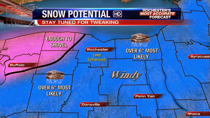
The area of low pressure set to reach us in 60 hours is currently just entering the Pacific Northwest this evening. The system will move quickly across the middle of the country and get some extra punch thanks to an upper air low diving out of Canada on Tuesday. Snow will break out early on Wednesday and should fall into early Thursday morning. All data indicated a favorable track for Western New York. Also the cyclone is forecast to deepen Wednesday evening although how deep remains a question. Following the storm, a shot of very cold air and wind return on Thursday with highs only in the teens.
At this time, I think 6" or more of snow is likely for much of the area with slightly lower amounts toward the Niagara Frontier. The "ifs" are always the killer in forecasting snow storms. Here are a few:
IF: The storm deepens and slows down, lake enhancement and blowing snow become an issue Wednesday night.
IF: The storm continues to move along quickly and weaker, snow will shut off quickly.
IF: The storm tracks 100 miles further South than expected....everyone thinks we suck at weather forecasting.
These are a few reasons why I don't spend much time changing my views from model run to model run. Whatever we see in the data tomorrow afternoon will be the likely indicator of how the storm will play out. Good night and good luck!
you guys rock at forecasting! just saying. this is a tough one though. lots of possibilities one being a really big one!
ReplyDeletewho is david wilson never heard of him on here
DeleteYeah, I would have to say that it is David Wilson...
DeleteChris
david wilson
ReplyDeleteMM channel 13 says maybe 3 to 4 inches boy this storm sounds like NBD with this and Scotts write up. Way too much uncertainty.
ReplyDeleteHe said "maybe *in excess* of 3 or 4 inches." Which I thought was an incredibly conservative call, but understandably so.
DeleteRC on 10 is saying over 6" on this morning's 10.2 forecast.
DeleteStarting to get worried we will get shafted latest NAM south and weaker not good.
ReplyDeleteIt's like 15 miles further south and a few millibars weaker. Not a big deal. Besides, it's the long range NAM.
DeleteOk CCCC good thanks when is Oz GFS come out?
ReplyDeleteSorry CCCC but NAM looks pretty far south and really a good deal weaker?
ReplyDeleteIt amounts to a negligible tick by NAM standards. And we still get a good deal of snow out of it.
Delete00z GFS starts running at midnight.
Yes CCCC is correct we still are in the 10-12 inch range on the latest NAM. GFS is late can not make that hope it is same track but stronger.
ReplyDeleteSREFs look tasty. Mean of just over 15 inches, but with a considerable amount of spread among the members. One kooky member has us getting next to nothing, another kooky one has us getting over 2 feet. No clustering is apparent.
ReplyDeleteDid I say 15? I meant 13. 15 is the mean I got when I removed the outlier-ish members from the graphic.
DeleteAgree with CCCC, NAM still looks good to me... We shall see what later model runs show, but if they stay consistent, NWS should start putting out headlines by tomorrow afternoon.
ReplyDeleteScott pretty sure of minimum of 6 inches and possibly more. Plus Thursday morning going to get cold and windy he said. And he mentioned a possible another storm a week from now wow.
ReplyDeleteYep, I hinted at the same thing earlier. This very well may not be a one-and-done deal.
DeleteOz GFS holds serve?
ReplyDeleteEssentially yes. Just negligible ticks on snow amounts and track/intensity.
DeleteAnyone know what the Oz EURO showed last night?
ReplyDeleteWhere is Snowdog?
ReplyDeleteTo me it looks like the GFS and NAM went much lower for snowfall than yesterday. To me it looks like we will be on the lower end. 6" maybe.
ReplyDeleteThanks for that... Debbie...
DeleteYes what else would we expect from the Snowdog ha ha. Dog do you know what the Oz EURO showed last night?
ReplyDeleteNwS discussion seemed to expect 7-12 this morning. I'd say the only thing against us at this point is how fast it will be going. This will no be a slow crippling storm but a healthy one non the less. Hopefully snow dog takes it for what it is and doesn't get disappointed its not 2ft!
ReplyDeleteWell, we have a watch up! Lets see how this pans out for us. Shout out to David, it has been awhile sinse I have contributed to the blog. Is Andrew still around? How about Charles W?
ReplyDeleteChris
It definitely will not be the BIG one we all crave but a mid-sized event likely, 6-8" unless it slows down.
ReplyDeleteSnowdog you may be over estimating the numbers for Rochester 3-5 more in line with current shift south.
DeleteHa ha Chris I think Andrew may have morphed into Snowdog. No David in a while on the blog. We have another legend called CCCC who has been a legend however he seems to be young and often sleeps late and posts late. Not sure about what this storm will bring RC on 10 this morning pretty confident of at least 6 and seemed hinting at more. Todays 12z runs of GFS and EURO should give exactly what will happen with this storm.
ReplyDeleteWhat do you guys think the wind will do?
ReplyDeleteRay
Winds pick up during day and Wednesday night. Interesting that it could be pretty cold and bitter Thursday morning just for one day. It then gets warm Friday and Saturday.
DeleteKeep hearing over a foot expected for Wednesday, with the heaviest snow to fall during the afternoon on Wednesday. Can't imagine what the commute will be like going home on Wednesday. Folks might want to begin to check out hotel rooms for Wednesday, and begin to stock up on groceries. Funny how those who talk about wanting for a "big one" don't take into account the impact it has on commuters and how dangerous it can be to travel.
ReplyDeleteWhoa Anon not going to be that bad and have not heard anyone say a foot yet. have to see what the model runs say today before anyone can say what they think accurately.
Deletehotel rooms? Not sure why that would be neccesary. We live in an area that can certainly handle anywhere from 6-12+ inches in 24 hours. As far a thruway being shut down and state of emergency, I still don't see where that is necessary. If people have been reading up on this, it will be relatively quick hitting, bot a slow Bomb dumping on us for extended period.
DeleteAny thoughts on the Governor declaring a State of Emergency for this one, and closing Thurway and surrounding expressways?
ReplyDeleteScott mentioned something about Sunday. I dont see that mentioned anywhere else. Anyone see anything for Sunday? I hope its nothing, I leave for Florida till April and if I get stuck Sunday I will flip out!
ReplyDeleteCCCC hinted at this last night however I do not see much of a concern for that as of now based on recent model runs. What do you think about the mid week storm David?
DeleteQuad-C -- where are you. Looking for an update as to what to expect from the Winter Storm. thanks.
ReplyDeleteWow the 6z NAM had us in the 14-18 inch range. I know it is the NAM but has not been that bad in short term.
ReplyDeleteWhy has no local weather folks mentioned this range. all are talking at least 4-6 or 6+, with heaviest snows in the Finger Lakes and Southern Tier. So can we expect 14 to 18 inches on Wednesday for ROC and the surrounding towns? Quad-C, what are you seeing?
DeleteI'm in Florida and flying home on Wednesday afternoon. Think I should book a hotel at the airport just in case?
ReplyDeleteSounds like Wednesday afternoon might be the height of the storm, so i could see your flight possibly getting delayed or cancelled. You would have no problem getting out of Florida and up the coast, but getting the ROC might get diverted somewhere else, or maybe they would delay you till Thursday in FL. I'm not flight expert. But Wednesday afternoon seems to be when it will be worst.
DeleteKW says 3-5 is more likely now. NBD for us, sigh...Just cracked a rat in my pants over this one.
ReplyDeleteKW tweeted this less than 10 minutes ago.
ReplyDeleteKevin Williams ✔ @whec_kwilliams
Awaiting midday data but feeling 6" solid for Wednesday storm with significantly more possible as we await to pinpoint track and intensity.
Kevin Williams is the master of hype. I am starting to get on board with snowdog that this will be NBD for us. 3 to 5 may definitely be likely. Storm is shifting SE now...
DeleteI don't know, KW was pretty bang on with past storms this season. And the south shift ended overnight.
Deleteis the tweet from KW legimiate; did I miss it or was this a troll (apologize if it was not, but you never know).
Deletesomebody posted as me above at 9:37, sorry folks, i was teaching at that point. could not have been me. I am not posting the rest of day so if someone does its not me
DeleteCan't sleep late during weekdays unfortunately :c
ReplyDeleteSo much for the south trend...overnight runs creeped back north. The 06z GFS actually has us in the bullseye now, but my gut tells me that it's an overcorrection and it will move back south a bit. The fast-moving nature of this storm should preclude truly huge amounts, but past experience tells me that we'll be dealing with somewhat more than what the Watch text states. I think yesterday's 18z NAM represents the absolute upper limit for this one, while the 00z GGEM is the lower limit. So I think we'll be looking at a 9-14 inch snowfall, highest across the western Finger Lakes and lowest in northwestern Orleans County. Lake enhancement could help metro Rochester especially later Wednesday as the temperature crashes, but partial ice cover is a concern.
Interesting that some of the SREF members are now clustered around the 30 inch mark as of the last run. Interesting...but also stupid. Sadly not gonna happen. The mean is 15 inches, which I think is a bit high but not totally outside of the realm of possibilities.
CCCC- I am in the southern tier, specifically Steuben County. Are we now out of the bullseye? Also, where do you think the rain/snow mix line will set up? I've seen it as high as northern PA and even into NY....Much thanks!
DeleteSteuben County might be a tad out of the bullseye depending on where you are. It's a huge county but the northern portion stands the best chance of staying all snow and receiving higher amounts. Exact placement of the mix line is still up in the air but my guess is that it spares the lion's share of the county.
DeleteI believe 10-12 is a legitimate number for the storm and will the idiot who keeps saying KW aid 3-5 stop.
ReplyDeleteThe latest GEFS has us for 1.1 inches of liquid and a 10:1 ratio gives us 11 inches of snow. Interesting the 7 day graphic for News 8 has us now with a mix on Wednesday?
ReplyDeleteJUST IGNORE ANY PREDICTIONS or ReTweets by ANYONE POSTING AS ANONYMOUS!
ReplyDeleteRatios should be on the order of 10:1 initially, but trend higher thoughout the day on Wednesday. The chance of any mix for Rochester during the important parts of the storm are very slim, but there may be a little light mix initially before the cold air begins to work its way down.
ReplyDeleteAs with every storm, we are going to have people here who try to troll with bad information i.e. saying modeled snowfall went way down when it actually didn't, talking about states of emergency and travel bans and such when there aren't any, making nightmarish apocalyptic predictions on snow amounts, etc. In these events it is always a good idea to check in with reputable sources of information, and to not make much of these claims until they can be verified with said reputable source.
It's pretty clear by your post that my roof is going to collapse.
DeleteOne 12z sample run is in the NAM which is usually pretty good short term model. The NAM I believe has us in the 16 inch range? It did shift North a bit? CCCC help?
ReplyDeleteNow worried that this is going to trend too far north not south to take us out of bigger snows. Where is CCCC?
ReplyDeleteThe NAM just went bananas...
ReplyDeleteOh NAM you're always good for a laugh. The storm will not be as amplified, produce as much snow for us or track as far north as what this beautiful pipe dream of a model run shows. I say this with confidence simply because of the NAM's extremely predictable biases. Its only real worth is inside 36 hours, and even then it can be a bit sketchy. Would make for a pretty awesome blizzard though I've gotta say. 50+ mph gusts and 16-20 inches of snow, that would certainly be a humdinger for the ages. Too bad it's merely the senile ramblings of an inferior meso model far removed from its element. I prefer to take the Hetsko approach and not live run to run. Sticking with my earlier call...not that it matters.
ReplyDeleteI agree CCCC and you do bring up a good point about the winds. I believe this will become a serious issue as this thing ramps up, causing seriously low visibilities along with extensive blowing/drifting.
ReplyDeleteThere will be a Blizzard in the Flower City within 2 days. Mark it down!!!!!!!!!!!!!!!!!!!!!!!!!!!!!!!!!!!!!!!!!!!!!!!!!!!!!!!!!!!!!!!!!!!!!!!!!!!!!!!!!!!!!!!!!!!!!!!!!!!!!!!!!!!!!!!!!!!!!
ReplyDeleteCCCC 12z GFS now and 12z EURO 2:00pm? Those will be the big 2 for our story?
ReplyDeleteIf it is snowy and bad, you know when it will hit. 8 AM. Just in time for everyone to be on the expressways, and just in time for our superintendents not to cancel school.
ReplyDeleteRemember my comment from last week about how we wouldn't see a 983mb low over the Catskills?
ReplyDeleteThe GFS has just come in with a 980mb low over the Catskills.
14-20 inches of snow from this run with 40-50 mph gusts.
I'm still incredibly skeptical, but this is the first run of an operational model that has full RAOB sampling to go along with it. Still choosing to not live run to run, but man if it isn't tempting to bite on recent trends...
There will be a Blizzard in the Flower city within 2 days. Mark it down!!!!!!!!!!!!!!!!!!!!!!!!!!!!!!!!!!!!!!!!!!!!!!!!!!!!!!!!!!!!!!!!!!!!!!!!!!!!!!!!!!!!!!!!!!!!!!!!!!!!!!!!
ReplyDeleteWhoops, did I say 14-20 inches? I meant 16-22 inches. I can't recall seeing this much snow depicted for us on a global model with such little lead time. We're in rare territory folks, even if it doesn't verify. Again, incredibly skeptical.
ReplyDeleteWe are 48 hours before the storm not that far away. I think all have been sampled. Plus the GFS was the weakest with the EURO the strongest so guess we wait until 12z EURO at 2:00pm but I think it will be BIG.
Deleteok so I am going to change my forecast up a little bit to 10-14 inches of snow. Again I have not done weather in a while but I am really liking the NAM this morning 18-24 inches of snow across our area.
ReplyDeletehttp://wxcaster.com/gis-snow-overlays.php3?STATIONID=BUF
Is the NAM really that far off? Take a look at the latest run of the GFS. Even if we do only see 10-14 inches we are going to have some very strong winds. We will have some pretty significant drifting.
ReplyDeleteDo you think that the NWS will upgrade to blizzard watch especially for the lakeshore communities
ReplyDeleteYou know this type of winter will end with a big storm.. because people ( outside this blog ) are sick of it. I know it, you know it, we all know it.
ReplyDeleteHey even snow lovers find the novelty of a good snow storm and the enjoyment of playing in the snow will quickly wear off as the month of March progresses. By late March I'm down right intolerant of snow and want to get through spring and into summer like weather as fast as possible. The only season I truly loathe here is early/mid spring--- sometimes we take far too long to transition from bad to good weather and the soggy grass & mud is downright miserable making it tough to do much outside.
DeleteI hear ya - but to be honest, even I am getting a little tired of it. It's been a good, old-fashioned winter. But enough already.
ReplyDeleteNever!
DeleteHi All,
ReplyDeleteThe 12z data from both the NAM & GFS certainly looks more impressive with snowfall amounts, & as the storm deepens & pulls off the east-northeast of us lake enhancement/effect will slowly, but surely take over as the air grows colder & the winds howl. I would expect blowing & drifting snows to become an issue to end Wednesday right into Thursday. Temperatures will likely plunge into the teens Wednesday night, maybe even upper single digits by early Thursday with some lake snows continuing through at least Thursday morning. Wind chills will likely drop below zero Wednesday night into Thursday too. Snow will likely break out late Tuesday night, with the worst of the storm snow will likely come later Wednesday morning through early Wednesday night the way it looks now, which means the ride home will probably be rough to say the least Wednesday! May not be that good early Thursday either with some lake snow & blowing & drifting snow reducing visibility greatly at times. Scott will be in & have some numbers tonight. I think this is going to be a VERY impressive one! Stay tuned for updates tonight & tomorrow...
Have a good one bloggers!
Best,
John
Wow! Sounds good if you like snow. Hopefully the timing is right to close the schools.
DeleteToo many snow total numbers being thrown out. Quad-CCCC what is your take on what the snow fall will be for Wednesday.
ReplyDeleteMaybe we should just add them together!
ReplyDelete12z EURO more south and not as strong so 10-12 may be more accurate for areas closer to lake areas south will get more.
ReplyDeleteThis storm is less than 40 hours away and yet our local mets still seem to be very uncertain? Have not seen any numbers posted by them and the NWS does not even have us in warning yet? Very confusing since I thought we had sampled models today and the average of all 3 of those models is well over a foot? Again seems like with all this modern weather technology predicting weather is more difficult.
ReplyDeleteYes the EURO seems to have backed off and 10 inches looks more realistic with the storm based on that run. Kind of thought the other models just were too strong.
ReplyDeleteAll the hype for nothing. NBD just like I predicted, unfortunately. Weather Underground lists 3-5 inches. You all bought into the KW hype as per say..
ReplyDeleteHere is where we stand so far:
ReplyDelete-Euro has 10-14 inches
-GGEM has 8-10 inches
-GFS has 16-22 inches
-NAM has 18-24 inches
So discounting the NAM and the GGEM for being the highest and lowest on numbers respectively, and adding a dose of realism to the GFS, we appear IMO to be looking at a general 10-18 inches, highest in the Finger Lakes and lowest well to the NW. Some people on AmericanWx, one of whom carries the "Meteorologist" tag, believe the Euro is being too stingy on precip in the cold sector, and Bernie Rayno believes we'll see an outcome closer to the GFS. I didn't see any important differences in the past 3 Euro runs, it has moved maybe a total of 10 miles over that span and varied by a millibar or two regarding intensity. I've also seen it underdo cold sector precip with numerous storms of this nature, so there's a case to be made for the higher end of the snowfall range. Or we can assume that the Euro has it bang on given its consistency and make a case for the lower end. Either way, the amount of wind with this system will result in major impacts regardless of snowfall amounts. We will see enough accumulation to make travel difficult when coupled with the wind.
And Snowdog, you really need to get your eyes checked. Weather Underground gives Rochester 10-16 inches in their forecast. Not that it matters, their forecasts are awful. 3-5 is way too low, by far and away lower than any forecast or model.
Not sure that was the real Snowdog which is annoying. I agree CCCC and my feeling is 12-16 inches for this storm. CCCC when do you feel the local mets will be putting numbers out and when will NWS put us to warning criteria. Also when do we get to now casting where models are not helpful much?
DeleteThe Snowdog above was not me. It was the impersonator.
DeleteAh man sorry Real Snowdog :\
DeleteI feel as though we'll see local numbers by the afternoon broadcasts, and Warnings by early tomorrow. Nowcasting begins when the thing appears on radar.
Ok thanks CCCC so we should take stock in the model runs tonight and tomorrow? Also not to get off this storm but as you hinted did you see the 12z EURO for next Monday/Tuesday?
DeleteThe model runs will matter as long as we can't see the storm on radar, so probably until the 12z cycle tomorrow. And I saw the storm after this one on the Euro. I don't even want to think about it at this point.
DeleteOne more question the 12z runs today particularly the GFS and EURO were completely sampled yes? If yes then would it not be safe that there should be major changes since we are less than 40 hours out?
DeleteIf by "major changes" you mean "significant storm to moderate event" then no, there should be no more major changes.
DeleteThis is where means from various models need to be looked at, not just one model run... Lets just wait for Scott to give his thoughts, he has access to past storm tracks/case studies as well as experience, oh and a degree in meteorology. Still interested to hear everyone's thoughts on snow totals. To be conservative, I am leaning towards Charles and his prediction of 10-14".
ReplyDeleteCCCC is right, KW has been pretty accurate this year. I think they all do a great job.
ReplyDeleteBuff NWS forecast discussion has initial estimates of 7-12".
ReplyDeleteLooks like WPC bit on the GFS track:
ReplyDeletehttp://www.hpc.ncep.noaa.gov/wwd/day2_psnow_gt_04.gif
http://www.hpc.ncep.noaa.gov/wwd/day2_psnow_gt_08.gif
http://www.hpc.ncep.noaa.gov/wwd/day2_psnow_gt_12.gif
QPF depiction averages 1 inch regionwide:
http://www.hpc.ncep.noaa.gov/qpf/d13_fill.gif
That would easily be a foot or more given what will likely be ratios of 12:1 and higher. A lot of our snow will be cold advection driven, which tends to produce decent ratios.
What wind speeds are we expecting? 25mph to 30mph??
ReplyDelete