
ANOTHER WINTER STORM APPROACHES
Ready or not, here it comes! Another winter storm is taking aim on western New York and promises to bring more significant snow to the region.
Low pressure will develop over western Pennsylvania tomorrow afternoon and then slowly make its way east through late Monday afternoon spreading widespread light to moderate snow across the region. The snow has already started in some areas this evening and will just continue hour after hour through late Monday night thanks to the pedestrian pace of the parent storm system.
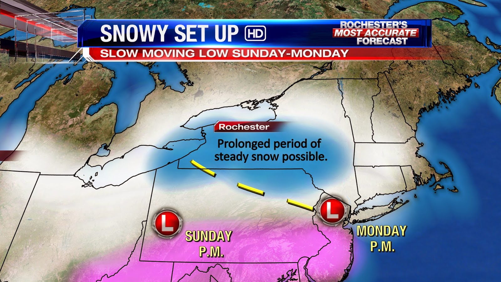
Compared to our storm from a week ago, this will be weaker system so heavy snow is not anticipated and winds shouldn't be as much of a issue. The problem with this storm will be the very slow movement which will allow the snow to really add up over the next 24 to 48 hours.
Here's a look at our latest snowfall forecast:

Another big challenge through Sunday will be determining precipitation type. A stationary front will reside to our south with much milder air found across the Southern Tier and Finger Lakes. South of the Thruway, a nasty mix of sleet and freezing rain could occur at times through Sunday afternoon holding back snowfall accumulations. North of the Thruway, all snow is expected and therefore more total snow is expected in this region.
Written By: Meteorologist Matt Jones
Thanks Matt a question as usual when we get a storm. Is this high confidence now with these numbers or is there still a potential bust for those north of the thruway?
ReplyDeleteHigh confidence at this point. It looks like any mixed precip will stay south of the Thruway.
DeleteHigh confidence at this point. It looks like any mixed precip will stay south of the Thruway.
DeleteWinter is just locked in until further notice...
ReplyDeleteThere is Weatherguy! You think 12-16 is accurate based on what you see?
ReplyDeleteYeah, won't be as dramatic as the last storm, but still impressive when all said and done...
DeleteWhen will the hardest fall? Plus when it starts although light to moderate it will go for 36 hours non-stop right?
DeleteThink schools will close? Or will it be slow enough they stay open?
ReplyDeleteAs Scott said Deja vu and the timing is not conducive for schools opening. Heaviest stuff they are saying is over night and Monday morning. Plus it is suppose to snow all day Monday. I know it is light to steady but that can cause just as much of a problem because it is hard to keep up with. Plus the mountains will be high.
ReplyDeleteI like that snow map! It is going to be a tough call with school. Wish it was a sure thing because it is difficult for people to find child care that they didn't originally need. I'm not saying they should close night before, I'm just saying this storm is slow so it is a toss up. Out distinct usually follows suit with surrounding districts, not the other way around so we shall see.
ReplyDeleteMatt or others, do you concur with the NWS timeline of amounts, or do you see any one time period producing more than they say in the warning bulletin in a given time slot?
ReplyDeleteChannel 10 has me in the 15-20" range. I like that better. I just don't think schools will close but I was wrong last week so who knows. KW tweeted about a possible bigger storm next week. I picked up about 3" today. Still snowing lightly right now in Gananda. Not much to the South or West showing on radar.
ReplyDeleteOk so Scott posted on FB this early AM that he was downing his totals to 6-10 total. This does not sound good. I was skeptical of schools closing anyways, they will definitely be open if he is correct. Need some morning updates from some of you guys! What is going on?
ReplyDeleteMore mixing here than originally thought.
ReplyDeleteLatest model data this morning is suggesting less snow accumulation than first thought. Scott will have an updated snowfall map out later this afternoon but right now, it's looking more like a 6-12" snow for the city.
ReplyDeleteI just read the NWS discussion and the only mixing they mentioned was south of Rochester. It's weird because in their warning statement they downed it to 8-12 but in the discussion they said totals could be 10-14. There was nothing in the discussion about having to scale back or giving any reasons why that was necessary.
ReplyDeleteIt's not so much a matter of mixing, but more how the parent low develops and what the trailing deformation zone does. I would think more people would land in the 8-10" range, but models have a hard time with this particular setup so don't be surprised if final totals fall above/below the projected range. We can't be in the bulls-eye for every storm, but it's still going to be a decent storm.
ReplyDeleteNow, off to work for me. Just the mention of snow does crazy things to people in the pharmacy world...
Thanks for update Matt. Does is still look like the most will fall overnight? It is it pretty steady throughout the time period?
ReplyDeleteThis has the makungs of a tough morning for me (and a lot of people). I will have to get up an hour early to snow blow (thank goodness I broke down and got a snow blower)
ReplyDeleteleave early enough to navigate traffic across town to daycare and then back across to work. I have a job where you really can't be late.
The December storm was one of these mornings. Guess I better get to bed early.
Good call on the snow blower. No doubt roads will be slick. Not sure it will be as bad as last Monday. It has to snow pretty decently at some point if we are going to get upwards of 10-12 inches. If it snows as light as it did yesterday I don't see 12" unless it literally does not stop from this afternoon- Monday evening.
ReplyDeleteNot surprised that Scott has brought the numbers down today. I thought all mets were ambitious with a 12-16 inch call last night. This storm is not impressive most will be lucky to get the lower end of 6-10 inches. Schools will not be impacted. The storm is weak and you have to be lucky to be in the deformation zone.
ReplyDeleteThis will drop to a WWA as I said it would be last night. there will be 3 to 5 additional inches by tomorrow. Another 1-3 tomorrow.
ReplyDeleteShould have known this had bust written all over it when CCCC has not commented.
ReplyDeleteCan't comment while I'm standing knee deep in snow in the middle of the woods.
DeleteThe models took our snow away. Damn you technology :<
ReplyDeleteThis doesn't have the makings of a headline downgrade just yet, but it also doesn't look like anyone will exceed a foot. We were going to have a relative clunker at some point after a long streak of storms meeting or exceeding expectations, but it should still be a decent snowfall. We're not done after this one either...the middle of this week will bring another chance of accumulating snow (probably a modest deal), with perhaps a few more chances to follow. Brutally cold at times as well.
This storm had been "scary" for mets from the get go. Pros; long duration, several little disturbances. Cons: no BIG disturbances, that warm air lurking. Regardless, it won't be a fun Monday morning commute. Heck, just a few inches wreaks havoc during any rush hour.
ReplyDeleteStacey
Here's to hoping the next one is a single low pressure that rides up the coastal plain with no messy transfers or sharp gradients of any kind. Just to make things easier for you fine folks :)
DeleteNot saying we don't like the forecasting challenge. Because we do! Even if it means a bust every now and then :) Not saying this is a total bust, by any means. Keeps us sharp...and humble!
DeleteStacey
This storm is really weak with not a great deal of precipitation. Not sure why all local mets jumped last night to 12-16 including Scott. Looks like MM had it pegged with his 10 inch call yet they too is for sure high now.
ReplyDeleteDuration. It was always going to be a relatively weak storm, but the duration was going to be the key to large amounts. And the models were almost entirely on board with 12+ until very recently, so there was no reason to not pull the trigger on 12+.
DeleteIs there any idea what at least it will start snowing in Rochester? Is the timing also a wreck too?
ReplyDeleteMid to late afternoon by the look of things. The morning commute tomorrow will still be tricky despite recent changes.
DeleteHave to give TWC credit on this one. They said 6-10 all along starting early yesterday.
ReplyDeleteAre you referring to the actual forecast from their actual experts, or just the automated local forecast with very little human input? Because the latter getting anything right is the definition of a blind squirrel finding a nut.
DeleteI can already hear the bust comments coming tomorrow morning when we wake up to 4 inches and only end up getting another 2 throughout the day. Yes, would lead to a 6" total, the low end of the updated forecast, but people will be a bit testy. We'll even start seeing some of those "I'm sick of this cold already let's get on with spring already" comments, oh joy! Personally, I'm looking forward to the extended cold & continued probability of snow this winter. Cheers!
ReplyDeletePlus it's not like we didn't get a really nice storm less than a week ago. Imagine this situation if we were working on an entire season without a good storm. The resulting mushroom cloud from the blog imploding would be visible from Toronto.
DeleteI find it interesting that we have more snow on the ground (in Penfield) than at any time during last year's brew-tail winter.
ReplyDeleteWe had so many powdery snowfalls and so much wind last winter that our snow pack was repeatedly ground into pixie dust. We would see a foot of accumulation from one storm get waxed down to a 5 inch depth in the span of a few days.
DeleteI am seeing some pretty heavy precipitation developing along I 90 between Rochester and Buffalo heading our way
ReplyDeletePretty intriguing banding feature developing nearby at the moment.
ReplyDeleteSnowing pretty good out my window. Harder than I expected.
DeleteModerate snowfall, large flakes in farmington
ReplyDeleteNothing of note happening here right now. The banding appears to have hit a wall just south of me.
ReplyDeleteThe baroclinic zone appears to have set up just south of the Thruway, and the convergence along the resulting stationary front is what's causing this banding to occur.
ReplyDeleteI am about 2 miles north of thruway and it is snowing at a good clip, how long do you see this band staying on top of me? I saw radar just couldn't do a loop or anything.
ReplyDeleteAbout a mile north of the thruway in Pittsford. It's snowing very large flakes. Just looking out the window. But it's fairly heavy. I can't tell yet how much it's accumulating yet. Casualty of the existing snow pack.
DeleteI scraped off a flat bench outsid my picture window. About .5-.75 so far maybe. Not quite an inch yet. Wish it would do this all day and night!
ReplyDeleteIs there any forecast update because I have not seen one besides what Scott said in FB early this morning.
ReplyDeleteAnd just like that the snow has slackened off to flurries
ReplyDeleteThis is what I do not get with this storm. It has been forecasted for day that this will be a long duration storm? I do not see that and do not see how they could have stated that since no model in the past 3 days had over a foot. I disagree with CCCC when he said that. They all had 8-10 at best. The only way we were going to get snow was being in that baroclinic zone and that is heavy for short periods not long duration snow? This whole forecast going back 3 days was confusing.
ReplyDeleteEven as recently as last night there were models showing a foot or more. The forecast was confusing but we were always dealing with a complex scenario.
DeleteWhen you look at the radar there is very little left to come from the west?
ReplyDeleteFunny how KW has bailed on the tweets since his forecast has busted from last night.
ReplyDeleteCan't really call it a bust... Even Scott and team had higher totals. The models changed since last night so they tweeted their forecast. Isn't that what forecasting is about? I'll admit I was hoping the 12-16 would be a sure thing but somehow I knew it was too good to be true.
ReplyDeleteShould say tweeked, not tweeted sorry
ReplyDeleteWell if you look at an earlier post I asked Matt about high confidence and he said yes. Just think they all jumped the gun last night and should have waited until this morning but no big deal. Farmington so are we just getting a few more inches from here on and is it going to stop earlier than thought?
ReplyDeleteI was up at Ontario Beach Park a little while ago...pretty wild scenery on that pier up there. Starting dumping big fat cotton balls right as I left too, and when I got home I found a rather nasty looking accident right in front of my apartment complex. About an inch down so far.
ReplyDeleteCCCC does not look like much left on radar is that rue?
ReplyDeleteLooked that way all afternoon. But it keeps snowing. Several inches here.
DeleteRadar returns are slowly building off to our west.
DeleteProbably got an inch finally here in Farmington maybe a touch more. CCCC is it sti forecasted to be a little heavier overnight or is that out the door now also?
ReplyDeleteLooks like a continuation of light to moderate rates.
DeleteI also need to remember they only ever had us getting 2-3 during today even before the totals lowered so thing may be on track who knows.
ReplyDeleteBelieve that band that sets up is suppose to move at a snails pace before it gets out of here maybe that is why it is predicted for long duration? Wish we would get an update from News 8.
ReplyDeleteKW just tweeted we will be going with low end so 6 inches at best.
ReplyDeleteEven the low end has us getting more than 6 inches...
DeleteYeah KWs low end was much higher than 6.
ReplyDeleteJN tweeted 8-12 inches north of thruway. Some areas close and east of the lake getting 12 plus.
ReplyDeleteHow the f*** is that incompetent fool at the airport only recording two tenths of an inch so far? And on 0.1 inches of liquid equivalent to boot. Are they trying to claim that our snow ratios have averaged 2:1 despite a lot of it being fluffy? That's absolutely comical. Maybe the airport really will come in with less than 6 inches, meanwhile every trained spotter in the area will measure 8-12.
ReplyDeleteApparently the spot I thought was going to be my measuring soloit is shielded by a tree etc. I opened the garage and there was probably 3" on driveway and that was about an hour ago.
ReplyDeleteConsistent with what I measured. Just snow blowed the driveway.
Delete3.75" average of 5 measurements. 5:30 PM.
Pittsford 1 mile North of Thruway.
CCCC is it going to snow lightly all night and all day tomorrow?
ReplyDeleteThere will likely be heavier bursts at times, but generally yes.
DeleteFinal numbers prediction: 8-10 for most, 10-12 in Wayne County, 3-6 within a 20 foot radius of the airport spotter.
ReplyDeletePrediction for totals by morning:
ReplyDeleteMost of ROC metro: 4-8
Airport: "MM"
JN just said 4-6 tonight and 4-6 tomorrow during the day. Scott has 8-12 with SE getting the most.
ReplyDeleteHow can the SE be getting more than the North. Last night it was the North getting more. I am so confused. Josh has Wayne count in 12".
DeleteYike. The radar looks terrible. Not much to the West once this next batch comes through. About 3" so far in Gananda. I hope we get at least 6" A far cry from the 15-20 channel 10 had last night. Things really changed overnight.
ReplyDeleteKeep in mind though, the radar hasn't looked impressive to our west all day, and yet it's continued to fill in over us!
DeleteYeah I agree Snowdog. Not sure where Scott sees 8-14 and JN has 4-6 more tonight and 4-6 more during day tomorrow. I see the nothing west on the radar and not much left.
ReplyDeleteIf radar trends told the whole story then last winter's December storm would've been over by 7pm. Instead it redeveloped and continued through the early AM. Have faith in the forecast.
ReplyDeleteBy the way, I stopped by my parents house this evening in Chili, literally 2 miles from the obs tower at ROC and there is at least 4" that fell so far...
ReplyDelete2 inches here so far. I've been under light radar returns for most of the day.
ReplyDeleteThe key here is tht they are expecting lull in the radar in a few hours but then it will fill back in again after midnight as the low slides to our south and strengthens. There wi also be lake enhancement for folks like Snowdog off of the north east wind. Channel 13's map wS different than last night but not as drastic of a change as I think we were all fearing. 4-6 overnight and 4-6 tomorrow is no walk In The park .
ReplyDeletePredictions on whether schools will close? A percentage would work......I say 50% chance
ReplyDelete25% Chance of Majority closing.
DeleteI say some will close like the usual ones.
ReplyDeleteFarmington and CCCC I do not get the lull thought once it started it was a long duration storm?
ReplyDeleteLong duration doesn't necessarily mean constant.
DeleteCCCC do you see what JN said on radar. Snow until midnight then a lull then picking up with heavier snow in the morning rush hour time? He also said it will snow until mid afternoon.
ReplyDeleteThat's actually a lull until midnight then filling in between midnight and 6am.
DeleteI doubt there will be any schools closings tomorrow. This system is nothing like last weeks storm. The lull will be here shortly. Looks like snow on and off all week. Snowpack will grow with no warm temps in sight.
ReplyDeleteI think some schools will have delays but very few if any will close.
ReplyDeleteYou think with 4-6 tonight and then tomorrow? There is a lot of snow out there with the foot plus for many areas last week. I think the roads and sidewalks will be poor if we get heavy stuff from 12 until 6:00am and continues even snowing lightly the rest of the day.
DeleteThe stuff on the ground doesn't matter, it's the stuff on the roads and sidewalks that counts. Those shouldn't be too difficult for the plow crews to maintain.
DeleteLooks like a pretty strong clipper Wednesday-Thursday.
ReplyDeleteThere really is no end in sight to this pattern. We may get a short reprieve around the 17th, but then it's back to the freezer. The coldest anomalies may also start to retrograde west at some point within the next 10 days, which could open the Gulf up for business if the subtropical jet cooperates (and there are limited signs that it might). Time will tell if that's a legitimate signal or just a head fake.
ReplyDeleteWith such a tight temperature gradient. No surprise.
ReplyDeleteBut isn't it a little cooler than expected?
Or is the airport screwing up the temprature readings now too?
Just do not see anymore snow coming on the radar? Am I missing something?
ReplyDeleteWell I see it coming and think it is going to snow harder for longer than people think tomorrow morning
ReplyDeleteAgreed, especially if it intensifies like the weather service is predicting it to.
DeleteI think the break in te radar is kind of like the usual dry slot we get. W have seen the moisture out ahead of the low and now as it travels to our south and eventually out south east the moisture will wrap back around and fill in as it strengthens a little near the coast. Also again should be a little lake enhancement coming off of the north east wind as JN pointed out when I watched him. What is this larger storm KW tweeted about? Is he referring to the Wednesday clipper or is something else on the models that the NWS is neglecting to mention because aside from the clipper they mentioned nothing out to sunday.
ReplyDeleteStarting to fill in back West now.
ReplyDeleteJust came by to say I have an inch of snow on the ground and forecast on wunderground now calling for 1-3" is all...what a dissapointment...radar is unimpressive...I said it all along, NBD folks! Certainly not getting 12+" like certain people have claimed!
ReplyDeleteYou claim to have only an inch so far? Welcome to the blog airport spotter person.
DeleteHa ha CCCC you are funny and that is so true. Looks like stuff is coming from the west.
ReplyDeleteI expected the snow to completely stop awhile ago, but recent Walmart adventures confirm that it has not. Still light to moderate, but mostly light. Up to about 3 inches so far.
ReplyDeleteI just checked innacuweather's site. Snow will start in 51 minutes.
ReplyDeleteThat feature makes me laugh.
Delete"Snow will start in 20 minutes"
*looks outside, snowing an inch per hour*
"Snow will end in 40 minutes"
*checks radar, heavy returns back to Chicago*
The official airport number has been revised to 3.4 inches as of 7pm, which is far more reasonable. Too bad there had to be such a hissy fit to get that to happen.
ReplyDeleteIt really is a joke... And I'm actually surprised how cold it is. Definitely helped to boost ratios.
ReplyDeleteYes Weatherguy it is 15 out right now and radar should be filled in by 10:00. I again think we may get a good hit over night of 6-8 inches especially areas north of thruway.
ReplyDeleteAnother 1.5" since clearing the driveway. Making 5" of fluffy snow at my house today.
ReplyDeleteI'd rather get an inch or two and I can just drive out tomorrow AM. Or 8 inches and I can wait until 7 as schools would likely be closed.
I think 4 more inches overnight and I have to snow blow at 5:30 is probably most likely.
What school do you work at SG?
ReplyDeletePittsford.
DeleteI don't want the day off. Things to teach. But snowy mornings are tricky to clear everything. Get the kids we're they need to be and get to school on time.
So. I'd prefer one extreme or the other. Personally.
Ladies and gentlemen, if you look off to the right you will see the AmericanWeather Upstate NY subforum, currently home to the intensely pungent and incredibly vocal Whinoceros. Once strictly indigenous to the larger subforums, the disease known as Whinitis has since migrated to the Upstate district and spread rapidly amongst its inhabitants. Mutations induced by the disease are so pronounced that its victims have been classified as a species distinct from humans since 1986, a species known colloquially as the Whinoceros. The most visible symptom of the mutation is a marked propensity to bitch and moan about things beyond mortal control, especially lack of snowfall in one's own backyard. Efforts are underway to manufacture a cure for the disease, but as of January 2015 there has been very little progress. Sympathetic treatments remain minimally effective, and in many cases can actually make symptoms worse over time.
ReplyDeleteWe thank you once again for embarking on our Weenies of the World Safari Tour. Please enjoy the rest of your stay.
What are you talking about? You must be drinking? No one really complaining on here today.
DeleteI was talking about the Upstate NY subforum on AmericanWeather, which has been engaged in a marathon style bitchfest all day long. Our cozy blog has indeed been well behaved today.
DeleteOh ha ha what are they bitching about?
DeleteSome of the CNY members are having a pity party and saying ridiculous crap like "Boston is the real snowbelt" and acting like they live in some sort of perpetual screw zone. They've been occupying a large percentage of the posting volume since this morning. It's pretty ridiculous.
DeleteCNY does well every winter so they should stop bitching. CCCC have looked at the radar and if yes am I wrong in that it looks not impressive and will be out by early sun rise?
DeleteI'm going to trust the forecasters and models over radar trends. It's an approach that usually works pretty well.
DeleteUp to 6 inches lakeside in Webster here , hoping schools close down tomorrow!
ReplyDeleteDo not think any schools will be closed the radar does not look good at all to our west. Think 2-4 inches at best.
ReplyDeleteWell you are wrong Anon because Lyons already closed tomorrow.
ReplyDeleteMark M on Fox News at ten says new data shows higher totals overnight way south ...showed their in-house model with snow totals by morning only another 4-5 for us but like 8 or 9 way south like dansville south....is this legit or is he whacked out? I thought we were in the better spot north of 90 and we're going to see lake enhancement? CCCC please speak some truth so I can go to sleep knowing the truth lol.
ReplyDeleteWe've already gotten 3-6 regionwide while areas south have gotten next to nothing, so I'm not surprised to see that shift in the models. Tack on another 4-5 and we'll have totals of 7-9 inches by morning, which would come close to verifying the lower end of most forecasts.
DeleteSome will be happy in the morning. Some will not.
DeleteAlso we're still in a good spot for lake influences. I'm not so sure that the models are picking up on it too well.
DeleteWell JN said earlier another 4-6 tonight and 4-6 tomorrow so they are off no matter what you justify. I know this one was tricky but even today they have been wrong all of them even when we are in now casting.
DeleteI'm pretty sure that 4-6 for tonight was the total for the night, not additional. We've already gotten most of that.
DeleteYeah that is what I am saying radar looks way south and north of the thruway will get minimal and south will now do better. It must have moved south. The weather models really do stink even with all the upgrades.
ReplyDeleteDisagree, radar is lying, been snowing all day long in North Gates, even when the radar showed no snow
DeleteWell has not snowed on the east side for the last 3 hours.
DeleteBingo. This is the sort of shallow lake influence in very cold air that the KBUF radar beam always struggles to detect.
DeleteBingo to Anon at 10:30, not 10:33
DeleteWell my radar looking out my window says it has not snowed in 3 hours in Pittsford.
DeleteSome of us don't live in Pittsford.
DeleteThat is your loss
Delete@ AnonymousFebruary 8, 2015 at 10:46 PM
DeleteI'm in Pittsford and picked up 7 inches for this event.
Luckily I didn't pick up an attitude.
Can someone tell me why Lyons schools are already closed tomorrow? Does that Superintendent know something everyone else does not?
ReplyDeleteTotals have to go up IMO. It's way colder than anticipated and it really hasn't stopped snowing as many have already mentioned.
ReplyDeleteCan confirm that the radar is indeed a dirty lying skank. Still decent rates in Webster, up to 4 inches now.
ReplyDeleteSomeone measured 10 inches in Gates. Did they use the same ruler to measure their tootsie roll? That number seems very suspicious.
ReplyDeleteYeah, no way, unless it's the evil twin of the notorious FAA guy at KROC...
ReplyDeleteIt's where he sent all of the missing snow.
DeleteJust read the NWS discussion they r confirming the heaviest snow overnight will fall betwren I 90 and I 86. Was hoping we would stay in the good stuff all night. I am not complaining though. Will be interesting to see what transpires by AM. Night bloggers
ReplyDeleteHeavy stuff south Scott just said. What a joke boy did know blow his forecast tonight. Even 'm got it right. They handled this storm badly had areas Southside about mix.
ReplyDeleteGreat storm 4 inches
ReplyDeletesolid 10-12" in north chili and still snowing
ReplyDelete3.5" what a joke!!! Total BUST!!
ReplyDeleteWait wait wait!! But Big Shot Bob said we'd all be getting 12 inches or more!! What a fat toad, he should never post here again with those outlandish predictions
ReplyDeleteAnon 6:55 you are a coward and an idiot. Stand by your anonymous posting and name call because I am sure you are a frustrated loser teacher who did not get a snow day. Sorry you had to work like everyone else you lazy piece of cow dung.
DeleteNope I am not a teacher...Just out to prove you were WRONG with all your guarantees of 12+" for all! Maybe next time you won't shoot your fat cake hole off and actually consider that someone else's opinion might make more sense than yours there fatty! Now get back on the couch, eat your potato chips, and refresh your weather models ya pumpkin pie haircutted freak!
DeleteDefinitely a BIG underperformer on this one. Very disappointing. I picked up about 6" but a far far cry from the original 15-20" that was forecasted by channel 10. I question the 10-12 reported in Chili.
ReplyDeleteHey 10 always hypes up their #s to increase ratings.
DeleteExtremely disappointing! Bust and NBD all around!!!
DeleteHave to laugh as I as watching 10 and JN talked about the week ahead. The anchor for the news said to him, "Why are you so giddy, happy, and excited about the cold weather ahead?" JN's response, "well it is going to be historic". Thought it was funny that she picked up on his happiness for below zero weather, etc.
ReplyDeleteJN needs a girlfriend...
DeleteWhy Snowdog that's what I measured. Some spots 10" and some 12"
ReplyDeleteSorry BIGLIFTER. Dont mean to question. I guess because I did not get that I question how others did. You got the jackpot. My apologies.
DeleteNo worries Snowdog. I just know what my snowblower had to clean off the driveway this morning.
DeleteI received 12.5 in Webster as of 10AM so its possible.
DeleteWhat are people seeing about Wednesday into Thursday and then Saturday into Sunday -- talk of another huge Winter Storm heading out way. Though I appreciate the snow -- we are beginning to run out of places to put it. Apt and work parking lots beginning have huge mountains of snow. Hate to see what the flooding will be like when it begins to warm up a little bit and the snow begins to melt. We might be headed for some major flooding.
ReplyDeleteWould like to know what folks see for Wednesday into Thursday and then Saturday into Sunday.
For god sakes don't ask Bob! That fat cat is wrong 10 times out of 10! CCCC is the only one with any real insight
DeleteI did not specifically ask Bob; where do you see "Bob" in my post. I put it out there to those who blog, including CCCC. At this point the only one who responded back was Andy, so unless he is really Bob impersonating as Andy. So word of advice before you jump to any conclusions -- be sure to read the post first to make sure you are not making a statement that is incorrect. Again, where do you see at any point in my post the name BOB.
DeleteI always look for CCCC's forecast .
7.5" at North Gates, just south of the canal.
ReplyDeleteJust little clippers this week, nothing big. A few inches here and there. Cold for sure.
ReplyDeleteAbout a week ago Wundergound's "best forecast" predicted this storm. They over predicted it for us, but none the less we did get a decent snow event. The only thing they show now that's over an inch for the next 10 day's is; 1"-3" Thursday, 1"-3" Saturday and 1"-3" next Tuesday. I wonder what the model readers see?
ReplyDeleteRegardless, it's staying cold and this snow pack isn't going anywhere anytime soon! Looks like single digit highs for Friday and Sunday.
As for my seasonal prediction of 75"-85", I had better keep paying off the Airport Spotter!.... LOL!
Andy
Thanks Andy.
DeletePeople are still complaining about lack of snow? Now I have officially seen everything.
ReplyDeleteYeah it's a very small number of people complaining.
DeleteWhatever Bog Shot Bob claims for snow this week/weekend, it will obviously be the opposite! Tread with caution on that turd!
ReplyDeleteWe got about 5-6" in Avon.
ReplyDeleteIt was very sleety/ping-y. Not really snow. More ice.
I laughed really hard at JN's antics. First it was 10-15" (jump up and down, Josh).... then it was "I've backed off my numbers"... then it was KW on the radio this morning saying we might get 1" today...
JN and KW just are not happen unless a major weather even is occurring.
DeleteI have but one accurate way to describe the pattern that Southern New England is dealing with and will continue to deal with:
ReplyDeletehttps://www.youtube.com/watch?v=A__bKr5ZHqY
Thursday's deal looks like a modest event right now. Uncertainty abounds regarding the one after it, so I'll just settle on it being yet another storm potential for someone in the east. As for the departing storm, looks like I tallied around 8 or 9 inches total with light lake fluff still falling. Regional totals will probably average 6-12 inches once the final spotter numbers come in. Kind of a far cry from how it looked initially, but no one has a right to complain since we've now gotten two significant storms in a week after several weeks of bleh. Preliminarily it appears that this storm pushed KROC to its monthly average for February. We reached it in just over 8 days. I won't be shocked if we double that number before we call it a wrap for the month.
And before I get any smartass replies, I'm referring to the number of inches of snow for the month, not the number of days in the month -_-
DeleteDefine modest -- what are you projecting snow fall total, but more so when the snow will begin to fall and add up?
DeleteModest = a few inches. Could end up being a bit more than that though.
Delete12.5" OF SNOW IN THE GREAT "CITY" OF WATERPORT, NY-ORLEANS COUNTY
ReplyDeleteSomeone in North Gates reported 18" from this system. Hard to believe when most picked up 6-10.
ReplyDeleteProbably the same person who reported 10 inches last night. Phony baloney is what it is.
DeleteI think we were lucky being on the south shore of LO to get that much.
DeleteI really do love that big ol' snow machine though. We wouldn't get a third of our current seasonal average without it.
DeleteThey could have gotten 18" over the length of the Winter Storm, especially if they live by Lake Ontario. Used to live in North Greece, and trust me the snow can add up over a period of time. In the past Metro could get 3-4 inches and North Greece by Cranberry Pond could get 7-8 inches easily. Again, it is possible.
DeleteI'm leaning towards a Mid Atlantic event for the second system. Also eyeing the middle of next week for a chance of something more substantial. That's way out in time with loads of uncertainty though, we have two massive arctic shots and two clippers to deal with before we get to that point.
ReplyDeleteCCCC -- what do you see the two clippers bringing as to snow amounts? Just want to know how to plan for each.
DeleteThe first one now looks like a 3-5 inch event including lake effect. The second one is still up in the air but I'm currently leaning towards not much impact here.
DeleteJust want to the snow plow drivers to get a break, and some time in between storms to figure out where to put all of the snow this is piling up. Two story house by where I live in the city has a mound of snow which is almost up to their 2nd floor window as there is no place to put the snow, as the private snow plow operators can't simply move it into the street. Worried about when it starts to melt and the amount of potential flooding it might cause.
ReplyDeleteFor later this week, can you say insulate you water piles, as them water piles might be a bursting again as they did last year during the polar vortex. Them piles will be a brustin.
Still snowing here in Chili. This is by far the deepest snow pack I can recall ever seeing.
ReplyDeleteFeel bad for folks who live in Boston. At this point they have 85.5" of snow just in January and February, and expecting more on the way. For those who always complain about missing out on the "big one"; kind of glad we are not experiencing what they are. Can you imagine 85+ inches of snow -- where to put it all, which is the big question being asked by those who live in Boston, where to be put all of the snow they currently have on the ground to make room for more which is expected over the next several days. They even borrowed snow melting machines from NYC; wonder if they put NY Yankee stickers on the machines and then sent them to Boston. Simply can't imagine that much snow here in Rochester.
ReplyDeleteTheir mayor announced that they're going to start dumping snow into the Boston Harbor.
DeleteDon't just any of the data coming from the Airport as to how much snow has fallen over the past week or so. Remember last year their number was much lower than what we got. Wonder where the guy is standing to measure the snow -- middle of the runway perhaps?
ReplyDeleteBehind an idling Bombardier CRJ 900 aircraft...
DeleteLooks like another several inches between Wednesday and Friday with the next clipper, lake enhancement and lake effect.
ReplyDeleteAirport storm total is 9.5 inches as of 1pm. Will probably finish a little above 10 if the lingering lake effect from this afternoon and tonight is included in the total. We are now running a 2 inch surplus for the season and a 16 inch surplus for the month of February, and have now received slightly more in the first 9 days than what we see on average for the ENTIRE month. We've also seen a good deal more in the same stretch than any whole month this season. Depth at the airport is now 17 inches with the region as a whole averaging 16 to 24 inches. And the ensemble means are still depicting well over an inch of liquid equivalent over the next two weeks with no end in sight to the cold pattern.
ReplyDeleteRemember when this winter was boring and lame?
Neither do I.
Sorry, bad math on my part. The storm total is actually 10.5, we got 5.5 yesterday and 5 today.
DeleteGeez how about another 16 inches of snow for Boston with the next storm if the GFS is right. Then possibly another big one during the weekend. I can't even think of an accurate word to describe this pattern.
ReplyDeletePress Load More below
ReplyDeleteYou pressed load more... for this?! LOL
ReplyDelete